
Multnomah Falls facts for kids
| Location | Columbia River Gorge, Multnomah County, Oregon, U.S. |
|---|---|
| Elevation | 627 ft (191 m) |
| Type | Tiered |
| Total height | 620 ft (189 m) |
| Height of longest drop | 542 ft (165 m) |
| Average width | 10 ft (3 m) |
| Number of drops | 2 |
| Average flow rate | 150 cu ft/s (4.2 m3/s) |
| Watercourse | Multnomah Creek |
| World height ranking | 434 |
Multnomah Falls is a waterfall located on Multnomah Creek in the Columbia River Gorge, east of Troutdale, between Corbett and Dodson, Oregon, United States. The waterfall is accessible from the Historic Columbia River Highway and Interstate 84. Spanning two tiers on basalt cliffs, it is the tallest waterfall in the state of Oregon at 620 ft (189 m) in height. The Multnomah Creek Bridge, built in 1914, crosses below the falls, and is listed on the National Register of Historic Places.
The land surrounding the falls was developed by Simon Benson in the early-twentieth century, with a pathway, viewing bridge, and adjacent lodge being constructed in 1925. The Multnomah Falls Lodge and the surrounding footpaths at the falls were added to the National Register of Historic Places in 1981. Contemporarily, the state of Oregon maintains a switchback trail that ascends to a talus slope 100 feet (30 m) above the falls, and descends to an observation deck that overlooks the falls' edge. The falls attract over two million visitors each year, making it the most-visited natural recreation site in the U.S. Pacific Northwest.
Contents
Formation
The waterfall formed at the end of a hanging valley created by the Missoula Floods.
Description
The falls drops in two major steps, split into an upper falls of 542 feet (165 m) and a lower falls of 69 feet (21 m), with a gradual 9 foot (3 m) drop in elevation between the two, so the total height of the waterfall is conventionally given as 620 feet (189 m). The two drops are due to a zone of more easily eroded basalt at the base of the upper falls.
Height
Multnomah Falls is the tallest waterfall in the state of Oregon. It is credited by a sign at the site of the falls, and by the United States Forest Service, as the second tallest year-round waterfall in the United States. However, there is some skepticism surrounding this distinction, as Multnomah Falls is listed as the 156th tallest waterfall in the United States by the World Waterfall Database (this site does not distinguish between seasonal and year-round waterfalls).
Water source
Underground springs from Larch Mountain are the year-round source of water for the waterfall, augmented by spring runoff from the mountain's snowpack and rainwater during the other seasons.

Trails
A paved foot trail leads to Benson Footbridge, a 45-foot (14 m)-long footbridge that allows visitors to cross 105 feet (32 m) above the lower cascade. After a viewpoint of the upper falls, the trail continues up many switchbacks to a platform at the top of the upper falls where visitors get a bird's-eye view of the Columbia Gorge and also of "Little Multnomah", a small cascade slightly upstream from the "upper" falls, which is not visible from ground level. The Mark O. Hatfield Memorial Trail starts at the falls and continues through the Oregon side of the Columbia River Gorge to Starvation Creek. The footbridge is named for Simon Benson, who in 1914 financed Italian stonemasons to construct the bridge.
The land and the building
Benson soon gave Portland land that included most of the falls as well as nearby Wahkeena Falls. The Oregon-Washington Railroad and Navigation Company gave Portland land at the base of Multnomah Falls contingent upon their agreement to build a lodge at the site. A few years later architect A.E. Doyle, who designed the Meier & Frank Building, was commissioned by the city to design the lodge, which was completed in 1925. The lodge is now on the National Register of Historic Places.

Access
In contrast to other falls along the Gorge, the Multnomah area is also reachable via a stretch of I-84 east of Troutdale, Oregon. The rest area and tunnel under the road (as well as the Union Pacific Railroad tracks) allow Interstate travelers from either direction to stop and visit the falls. During the summer season and holidays the parking lot along the freeway access can fill up very quickly which prompts a gate to come down and a reader board sign along the freeway before the offramp flashes that the parking lot is full.
Falling boulders
On Labor Day in September 1995, a 400-ton boulder, loosened by erosion, fell 225 feet (69 m) from the face of the waterfall into the upper cascade pool, above Benson Bridge. It caused a 70-foot (21 m) splash of water and gravel to wash over the footbridge, causing minor injuries to twenty members of a wedding party that happened to be on the bridge posing for photos at the time.
On January 9, 2014, a falling rock damaged a portion of the bridge walkway and concrete railing, leading the Forest Service to close the bridge until repairs were completed.
Images for kids
-
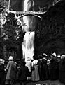
Visitors at the falls c. 1915
-
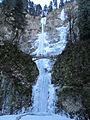
The falls while frozen in December 2013
-

Onlookers on the north bank of the Columbia River in Washington view Multnomah Falls to the south
-
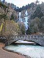
Multnomah Creek Bridge
.jpg)
_-_09.JPG)

_-_29.JPG)
See also
 In Spanish: Multnomah Falls para niños
