
Muriwai facts for kids
Muriwai, also called Muriwai Beach, is a coastal community on the west coast of the Auckland Region in the North Island of New Zealand. The black-sand surf beach and surrounding area is a popular recreational area for Aucklanders. Gannets nest there in a large colony on the rocks.
The New Zealand Ministry for Culture and Heritage gives a translation of "water's end" for Muriwai.


Contents
Location
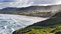
Muriwai is approximately 17 km west of Kumeū, 42 kilometres northwest of Auckland city, at the southern end of an unbroken 50 kilometre stretch of beach which extends up the Tasman Sea coast to the mouth of the Kaipara Harbour. One of several popular beaches in the area (others include Piha and Karekare), it experiences a population explosion in summer when Aucklanders head to the sea. It is in the Rodney Ward of the Auckland Region.
Governance
Muriwai is part of the Local Government Rodney Ward of Auckland Council and is part of the Kumeu Subdivision of the Rodney Local Board.
Muriwai is in the Helensville Electorate however proposed Boundary changes in late 2019 could change this.
Demographics
| Historical population | ||
|---|---|---|
| Year | Pop. | ±% p.a. |
| 2006 | 1,044 | — |
| 2013 | 1,131 | +1.15% |
| 2018 | 1,248 | +1.99% |
Muriwai had a population of 1,248 at the 2018 New Zealand census, an increase of 117 people (10.3%) since the 2013 census, and an increase of 204 people (19.5%) since the 2006 census. There were 444 households. There were 636 males and 612 females, giving a sex ratio of 1.04 males per female. The median age was 40.1 years, with 282 people (22.6%) aged under 15 years, 165 (13.2%) aged 15 to 29, 690 (55.3%) aged 30 to 64, and 111 (8.9%) aged 65 or older.
Ethnicities were 94.2% European/Pākehā, 11.1% Māori, 2.6% Pacific peoples, 3.8% Asian, and 3.1% other ethnicities (totals add to more than 100% since people could identify with multiple ethnicities).
The proportion of people born overseas was 18.3%, compared with 27.1% nationally.
Although some people objected to giving their religion, 69.5% had no religion, 18.5% were Christian, and 5.0% had other religions.
Of those at least 15 years old, 333 (34.5%) people had a bachelor or higher degree, and 81 (8.4%) people had no formal qualifications. The median income was $45,700. The employment status of those at least 15 was that 552 (57.1%) people were employed full-time, 168 (17.4%) were part-time, and 33 (3.4%) were unemployed.
Activity

- Surfing is the main pastime at Maukatia (Maori Bay) and Muriwai Beach. Other pastimes enjoyed at Maukatia include paragliding and hang gliding, especially when the prevailing southwesterly wind provides favourable conditions.
- Fishing is also popular, although dangerous in many places.
- Bush walking is encouraged, with boardwalks in place, and the 'Hilary Trail' passes through Muriwai.
- Driving along the beach is popular, especially at fishing contest time, although vehicles have been mass stranded in past years.
- Surf boards, surfing tuition and sand yachts are available for hire at the Muriwai Surf School near the beach.
- There are many mountain bike trails up in the pines, mainly downhill and freeride trails.
- The beach was used extensively for motor racing from the 1920s through to the 1940s.
- Horse riding is popular along the beach, as well as through the extensive tracks behind the sand dunes. Access is also available through the Woodhill Forest Equestrian Park.
Geology
Sand and rock (sedimentary), older volcanic material, with many concretions and layers in the cliff walls. A blowhole plays often. The shore platform is also well jointed, with the main rock type being piha conglomerate.
Muriwai Beach has black sand, caused by the iron content derived from the ancient volcanoes in the area, including the large Kaipara Volcano which was situated offshore from the Kaipara Heads, and erupted 23-16 million years ago. The black sand is moved up the west coast of the North Island by longshore drift.
Muriwai Regional Park
Much of the land at the southern end of the beach is part of the Muriwai Regional Park. Maukatia (Maori Bay) to the south is separated from Muriwai Beach by Otakamiro Point, with its steep cliffs and rocky nesting areas that are home to the region's only colony of Australasian gannets. The site of the gannetry has been identified as an Important Bird Area, by BirdLife International.
The Regional Park includes a golf course along Coast Rd, and the area north of Okiritoto Stream is known as the "Five Mile Strip" or "Five Mile Block" as this is its approximate length. A horse park (parking area for horse floats and trucks to unload) is located just to the south of Okiritoto Stream. 4WD access on to the beach is also provided at this point.
The Five Mile Block provides recreational trails for both walkers and horse riders. Cyclists enjoy the Coast Rd as far as the top of the Regional Park (but are not permitted into the adjoining Woodhill Forest) by the forest managers. Dog walkers also frequent the area, as it provides a wide range of off-leash walking opportunities.
- From the gannet colony
-
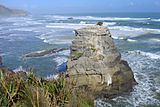
Wild coast and gannet colony - Motutara Island
-
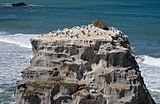
A closer look at the colony
-
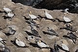
Gannets at Muriwai; adults and one young bird
-
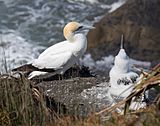
Adult and child gannet at Muriwai


2013 shark attack
In February 2013, filmmaker Adam Strange was killed at Muriwai Beach while swimming about 200m offshore, when he was attacked by a small group of great white sharks. As a result, Muriwai Beach was closed for a number of days. Initial reports suggested the culprit was a bronze whaler, but it was later deemed more likely a great white was to blame. It was the first fatal shark attack in more than three decades in New Zealand.
Images for kids
-
Muriwai Beach looking north

