
Naguabo, Puerto Rico facts for kids
Quick facts for kids
Naguabo
Municipio Autónomo de Naguabo
|
|||
|---|---|---|---|
|
Town and Municipality
|
|||

View of Naguabo from El Yunque
|
|||
|
|||
| Nicknames:
"Cuna de Grandes Artistas", "Los Enchumbaos"
|
|||
| Anthem: "Mi Naguabo del querer, Mi Naguabo del soñar" | |||

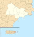
Map of Puerto Rico highlighting Naguabo Municipality
|
|||
| Commonwealth | |||
| Founded | July 15, 1821 | ||
| Barrios | |||
| Area | |||
| • Total | 60.1 sq mi (155.57 km2) | ||
| • Land | 52.1 sq mi (135 km2) | ||
| • Water | 7.9 sq mi (20.57 km2) | ||
| Population
(2010)
|
|||
| • Total | 26,720 | ||
| • Density | 444.6/sq mi (171.76/km2) | ||
| Demonym(s) | Naguabeños | ||
| Time zone | UTC−4 (AST) | ||
| ZIP Codes |
00718, 00744
|
||
| Area code(s) | 787/939 | ||
| Major routes | |||


Naguabo is a town and municipality in Puerto Rico located in the east coast of the island bordered by the Vieques Passage, north of Humacao; south of Río Grande and Ceiba; and east of Las Piedras. Naguabo is spread over 8 barrios and Naguabo Pueblo (the downtown area and the administrative center of the city). It is part of the San Juan-Caguas-Guaynabo Metropolitan Statistical Area.
Naguabo is renowned for and is said to be the birthplace of the pastelillo de chapín, which is a popular food in Puerto Rico. It is trunkfish wrapped inside deep-fried flour dough. Pastelillos de chapín can be found in almost any seaside establishment on the island.
Contents
Geography
Naguabo is located in the southeast region of Puerto Rico. The northern part is within the Luquillo Mountain Range, which contain the Picos (tips) of the Este and the Oeste, at 3,448 and 3,346 feet (1,051 and 1,020 m) of altitude above sea level, respectively.
Cityscape
Barrios
- Daguao
- El Duque
- Húcares
- Santiago y Lima
- Maizales
- Mariana
- Peña Pobre
- Río Blanco
- Pueblo
Tourism
Landmarks and places of interest
- Algodones Key
- Caribbean National Forest
- Naguabo Beach
- Punta Lima Beach
- Ramón Rivero "Diplo" Monument
- Tropical Beach
- Yudelmi Center
- Pedro Flores Monument
- Hucares Beach
- City Square (Plaza De Recreo)
- The malecón
Culture
Festivals and events
- Pedro Flores Week - March
- Chapín Festival - February
- Diplo Festival - June
- Virgen del Carmen Fiesta - July 16
- Patron Saint Festival - October 7
Transportation
There is public transportation in Naguabo. It operates from 6:00 a.m. using the "Pisicorre" bus. There are 52 bridges in Naguabo.
Economy
Demographics
| Historical population | |||
|---|---|---|---|
| Census | Pop. | %± | |
| 1900 | 10,873 | — | |
| 1910 | 14,365 | 32.1% | |
| 1920 | 15,788 | 9.9% | |
| 1930 | 18,212 | 15.4% | |
| 1940 | 19,180 | 5.3% | |
| 1950 | 21,019 | 9.6% | |
| 1960 | 17,195 | −18.2% | |
| 1970 | 17,996 | 4.7% | |
| 1980 | 20,617 | 14.6% | |
| 1990 | 22,620 | 9.7% | |
| 2000 | 23,753 | 5.0% | |
| 2010 | 26,720 | 12.5% | |
| 2020 | 23,386 | −12.5% | |
| U.S. Decennial Census 1899 (shown as 1900) 1910-1930 1930-1950 1960-2000 2010 2020 |
|||
Images for kids
-
Subdivisions of Naguabo.
-
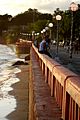
Beach, boardwalk, street lamps and people in Naguabo
-
Río Blanco reservoir in Naguabo
-
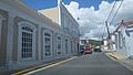
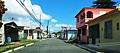
Street in Naguabo
-
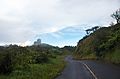
Residential street in Naguabo
-
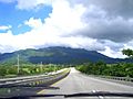
Highway from Naguabo to Ceiba
-
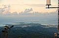
Northeast Puerto Rico from atop El Yunque
-
Radar towers in Naguabo


.jpg)
See also
 In Spanish: Naguabo para niños
