
Nanticoke, Pennsylvania facts for kids
Quick facts for kids
Nanticoke, Pennsylvania
|
||
|---|---|---|

Aerial view of Nanticoke, looking southwest.
|
||
|
||

Location of Nanticoke in Luzerne County, Pennsylvania.
|
||

Nanticoke, Pennsylvania
Location in Pennsylvania

Nanticoke, Pennsylvania
Location in the United States
|
||
| Country | United States | |
| State | Pennsylvania | |
| County | Luzerne | |
| Settled | 1800 | |
| Incorporated (borough) | 1874 | |
| Incorporated (city) | 1926 | |
| Government | ||
| • Type | City Council | |
| Area | ||
| • Total | 3.55 sq mi (9.20 km2) | |
| • Land | 3.46 sq mi (8.95 km2) | |
| • Water | 0.10 sq mi (0.25 km2) | |
| Elevation | 696 ft (212 m) | |
| Population
(2010)
|
||
| • Total | 10,465 | |
| • Estimate
(2019)
|
10,312 | |
| • Density | 2,982.93/sq mi (1,151.61/km2) | |
| Time zone | UTC-5 (Eastern (EST)) | |
| • Summer (DST) | UTC-4 (EDT) | |
| Zip code |
18634
|
|
| Area code(s) | 570 Exchanges: 735,740 | |
| FIPS code | 42-52584 | |

Nanticoke is a city in Luzerne County, Pennsylvania, United States. As of the 2010 census, the population was 10,465, making it the third largest city in Luzerne County. It occupies 3.5 square miles of land. The city can be divided into several sections: Honey Pot (northwestern Nanticoke), (northern and central Nanticoke), and Hanover Section (southeastern Nanticoke). It was once an active coal mining community. Today, the 167-acre main campus of Luzerne County Community College is located within the city.
Contents
History
.jpg)
.jpg)
The name Nanticoke was derived from Nantego, the Native American tidewater people who moved here when their Maryland lands were spoiled for hunting by the colonial settlement in 1608.
Nanticoke was incorporated as a village in 1830; Nanticoke was chartered by the Pennsylvania Legislature as a borough on January 31, 1874.
Nanticoke experienced its greatest increase in population between 1917 and 1925 and qualified to become a Third Class City. The citizens voted in the fall of 1924 to form a city government, and elections were held the following year. The new city government consisted of a Mayor and four Councilmen who took office in January 1926, which was the official date of becoming a Third Class City. The first mayor of Nanticoke City was Dan Sakowski.
Samuel H. Kress opened his first store, which grew into the national S. H. Kress & Co. chain, in Nanticoke.
The Concrete City, built by the Delaware, Lackawanna and Western Railroad's coal division in 1911 to house its workers, is located near the Hanover section of Nanticoke. Abandoned since 1924, it was designated a historic site in 1998, and its remains still stand as a tourist attraction. The original road that used to run to the structures has been bulldozed, though it still remains on maps. There is an alternate entrance route that does not appear on maps. It can be found at the end of Bliss & Mosier St's - Hanover section of Nanticoke
Nanticoke city officials voted unanimously to apply to the state for Act 47, or economically distressed city status, which was granted in 2006. Nanticoke faced a projected $700,000 deficit that year, with revenues flat and falling far behind expenses.
Demographics

| Historical population | |||
|---|---|---|---|
| Census | Pop. | %± | |
| 1880 | 3,884 | — | |
| 1890 | 10,044 | 158.6% | |
| 1900 | 12,116 | 20.6% | |
| 1910 | 18,877 | 55.8% | |
| 1920 | 22,614 | 19.8% | |
| 1930 | 26,043 | 15.2% | |
| 1940 | 24,387 | −6.4% | |
| 1950 | 20,160 | −17.3% | |
| 1960 | 15,601 | −22.6% | |
| 1970 | 14,638 | −6.2% | |
| 1980 | 13,044 | −10.9% | |
| 1990 | 12,267 | −6.0% | |
| 2000 | 10,955 | −10.7% | |
| 2010 | 10,465 | −4.5% | |
| 2020 | 10,628 | 1.6% | |
At its height, in the 1930s, the city of Nanticoke was home to over 27,000 people. As of the census of 2000, there were 10,955 people, 4,850 households, and 2,905 families residing in the city. The population density was 3,124.0 people per square mile (1,205.1/km2). There were 5,487 housing units at an average density of 1,564.7 per square mile (603.6/km2). The racial makeup of the city was 98.84% White, 0.27% African American, 0.10% Native American, 0.26% Asian, 0.01% Pacific Islander, 0.16% from other races, and 0.37% from two or more races. Hispanic or Latino of any race were 0.45% of the population.
There were 4,850 households, out of which 23.5% had children under the age of 18 living with them, 42.6% were married couples living together, 12.7% had a female householder with no husband present, and 40.1% were non-families. 35.7% of all households were made up of individuals, and 20.0% had someone living alone who was 65 years of age or older. The average household size was 2.21 and the average family size was 2.88.
In the city, the population was spread out, with 19.7% under the age of 18, 7.5% from 18 to 24, 25.8% from 25 to 44, 23.7% from 45 to 64, and 23.3% who were 65 years of age or older. The median age was 43 years. For every 100 females, there were 87.6 males. For every 100 females age 18 and over, there were 83.3 males.
The median income for a household in the city was $26,169, and the median income for a family was $35,444. Males had a median income of $30,125 versus $20,265 for females. The per capita income for the city was $15,348. About 11.5% of families and 15.8% of the population were below the poverty line, including 24.1% of those under age 18 and 11.4% of those age 65 or over.
Geography
Nanticoke is located at 41°11′58″N 75°59′57″W / 41.19944°N 75.99917°W (41.199514, -75.999119).
According to the United States Census Bureau, the city has a total area of 3.6 square miles (9.3 km2), of which 3.5 square miles (9.1 km2) is land and 0.1 square miles (0.26 km2), or 3.05%, is water. Nanticoke is located in the Wyoming Valley (near the Susquehanna River). The elevation is 696 feet (212 m). Both the Lower Broadway Street Bridge and the South Cross Valley Expressway cross over the Susquehanna River and connect Nanticoke with Plymouth Township. The topography of Nanticoke City is hilly.

Transportation
Major highways
 I-81
I-81 US 11
US 11 PA 29
PA 29
Public transportation
- Nanticoke is served by the Luzerne County Transportation Authority, which provides bus service to the city and other communities within Luzerne County and Lackawanna County.
Rail
- Rail line service is provided by the Norfolk Southern Railway; the city is situated on the railroad's Sunbury Line (where a small freight yard is located).
Airports
- The Wilkes-Barre/Scranton International Airport is located in Pittston Township. The airport is served by eight international airlines and has hosted Air Force One on regional presidential visits several times in the past. In the spring of 2002, the airport began offering an increased number of non-stop flights across the nation. Service is provided by American Airlines, Delta Air Lines, and United Airlines.
- The Wilkes-Barre Wyoming Valley Airport is located three miles north of Wilkes-Barre.
- The Hazleton Municipal Airport is located two miles northwest of Hazleton.
Notable people

- Nick Adams, actor, screenwriter, best known to audiences as Johnny Yuma in the TV series The Rebel
- Steve Bilko, played professional baseball for the St. Louis Cardinals
- Al Cihocki, a Major League Baseball infielder who played for the Cleveland Indians
- Stanley Dudrick, surgeon who developed total parenteral nutrition
- John S. Fine, 35th Governor of Pennsylvania from 1951 to 1955
- Pete Gray, played major league baseball after having lost his right arm in a childhood accident; his life is depicted in the 1986 television production A Winner Never Quits
- Paul Kanjorski, former U.S. Representative for Pennsylvania's 11th congressional district
- Jerry Orbach, former cast member of Law & Order
- Frank Piekarski, an American football player and coach who later served as a judge in Pennsylvania
- David A. Randall, an American book dealer, librarian, and bibliographic scholar
- Doug Turley, an American football end for the Washington Redskins
Images for kids
-
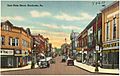
An old postcard of Main Street
.jpg)
See also
 In Spanish: Nanticoke (Pensilvania) para niños
