Narromine County facts for kids
Quick facts for kids NarromineNew South Wales |
|||||||||||||||
|---|---|---|---|---|---|---|---|---|---|---|---|---|---|---|---|

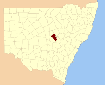
Location in New South Wales
|
|||||||||||||||
|
|||||||||||||||
Narromine County is one of the 141 Cadastral divisions of New South Wales. It is located between the Bogan River on the west and the Macquarie River on the east, in the area around Narromine.
Narromine is believed to be derived from a local Aboriginal word.
Parishes within this county
A full list of parishes found within this county; their current LGA and mapping coordinates to the approximate centre of each location is as follows:
| Parish | LGA | Coordinates |
|---|---|---|
| Algalah | Narromine Shire | 32°14′54″S 147°49′04″E / 32.24833°S 147.81778°E |
| Backwater | Narromine Shire | 32°13′54″S 148°08′04″E / 32.23167°S 148.13444°E |
| Barton | Narromine Shire | 32°10′54″S 147°53′04″E / 32.18167°S 147.88444°E |
| Biridoo | Narromine Shire | 32°32′54″S 148°21′04″E / 32.54833°S 148.35111°E |
| Buddah | Narromine Shire | 32°05′54″S 148°10′04″E / 32.09833°S 148.16778°E |
| Bulgandramine | Narromine Shire | 32°37′54″S 148°12′04″E / 32.63167°S 148.20111°E |
| Burrabadine | Dubbo Regional Council | 32°12′54″S 148°30′04″E / 32.21500°S 148.50111°E |
| Caloma | Narromine Shire | 32°38′54″S 148°18′04″E / 32.64833°S 148.30111°E |
| Cathundril | Narromine Shire | 32°05′54″S 146°42′04″E / 32.09833°S 146.70111°E |
| Cowal | Narromine Shire | 32°12′54″S 148°00′04″E / 32.21500°S 148.00111°E |
| Dandaloo | Narromine Shire | 32°10′54″S 147°41′04″E / 32.18167°S 147.68444°E |
| Deribong | Narromine Shire | 32°11′54″S 147°47′04″E / 32.19833°S 147.78444°E |
| Doonside | Narromine Shire | 32°14′54″S 147°53′04″E / 32.24833°S 147.88444°E |
| Draggy | Narromine Shire | 32°22′54″S 147°52′04″E / 32.38167°S 147.86778°E |
| Dungary | Dubbo Regional Council | 32°17′54″S 148°28′04″E / 32.29833°S 148.46778°E |
| Enerweena | Narromine Shire | 32°26′54″S 147°58′04″E / 32.44833°S 147.96778°E |
| Enmore | Narromine Shire | 32°05′54″S 147°48′04″E / 32.09833°S 147.80111°E |
| Frost | Narromine Shire | 32°21′54″S 148°10′04″E / 32.36500°S 148.16778°E |
| Gilmour | Narromine Shire | 32°33′54″S 148°05′04″E / 32.56500°S 148.08444°E |
| Gin Gin | Narromine Shire | 32°00′54″S 148°03′04″E / 32.01500°S 148.05111°E |
| Gin Gin | Warren Shire | 31°55′54″S 147°58′04″E / 31.93167°S 147.96778°E |
| Goan | Narromine Shire | 32°03′54″S 148°00′04″E / 32.06500°S 148.00111°E |
| Gradell | Narromine Shire | 32°30′54″S 148°03′04″E / 32.51500°S 148.05111°E |
| Gundong | Narromine Shire | 32°33′56″S 148°12′46″E / 32.56556°S 148.21278°E |
| Hervey | Parkes Shire | 32°42′54″S 148°17′04″E / 32.71500°S 148.28444°E |
| Meringo | Narromine Shire | 31°59′54″S 147°46′04″E / 31.99833°S 147.76778°E |
| Mingelo | Parkes Shire | 32°47′54″S 148°11′04″E / 32.79833°S 148.18444°E |
| Minore | Dubbo Regional Council | 32°11′54″S 148°25′04″E / 32.19833°S 148.41778°E |
| Momo | Narromine Shire | 32°24′54″S 148°21′04″E / 32.41500°S 148.35111°E |
| Mullah Back | Narromine Shire | 31°59′54″S 147°56′04″E / 31.99833°S 147.93444°E |
| Mullah | Narromine Shire | 31°53′54″S 147°56′04″E / 31.89833°S 147.93444°E |
| Myall Camp | Narromine Shire | 32°20′54″S 148°04′04″E / 32.34833°S 148.06778°E |
| Narromine | Narromine Shire | 32°17′54″S 148°20′04″E / 32.29833°S 148.33444°E |
| Nelson | Narromine Shire | 32°21′54″S 148°00′04″E / 32.36500°S 148.00111°E |
| Obley | Narromine Shire | 32°21′54″S 148°16′04″E / 32.36500°S 148.26778°E |
| Temoin | Narromine Shire | 32°06′54″S 147°56′04″E / 32.11500°S 147.93444°E |
| The Oaks | Narromine Shire | 32°30′54″S 148°09′04″E / 32.51500°S 148.15111°E |
| Timbrebongie | Narromine Shire | 32°10′54″S 148°09′04″E / 32.18167°S 148.15111°E |
| Tomingley | Narromine Shire | 32°29′54″S 148°16′04″E / 32.49833°S 148.26778°E |
| Trangie | Narromine Shire | 32°02′54″S 147°53′04″E / 32.04833°S 147.88444°E |
| Turribung | Narromine Shire | 32°14′54″S 147°41′04″E / 32.24833°S 147.68444°E |
| Tyrie | Narromine Shire | 32°08′54″S 147°36′04″E / 32.14833°S 147.60111°E |
| Waterloo | Narromine Shire | 32°22′54″S 147°45′04″E / 32.38167°S 147.75111°E |
| Weemabah | Narromine Shire | 32°00′54″S 148°11′04″E / 32.01500°S 148.18444°E |
| Wentworth | Narromine Shire | 32°13′54″S 148°15′04″E / 32.23167°S 148.25111°E |
| Willydah | Narromine Shire | 32°07′54″S 148°00′04″E / 32.13167°S 148.00111°E |
| Yarradigerie | Narromine Shire | 32°11′54″S 147°32′04″E / 32.19833°S 147.53444°E |

All content from Kiddle encyclopedia articles (including the article images and facts) can be freely used under Attribution-ShareAlike license, unless stated otherwise. Cite this article:
Narromine County Facts for Kids. Kiddle Encyclopedia.
