National Register of Historic Places listings in Caroline County, Virginia facts for kids
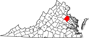
This is a list of the National Register of Historic Places listings in Caroline County, Virginia.
This is intended to be a complete list of the properties and districts on the National Register of Historic Places in Caroline County, Virginia, United States. The locations of National Register properties and districts for which the latitude and longitude coordinates are included below, may be seen in an online map.
There are 22 properties and districts listed on the National Register in the county, including 1 National Historic Landmark.
Current listings
| Name on the Register | Image | Date listed | Location | City or town | Description | |
|---|---|---|---|---|---|---|
| 1 | Auburn |
(#06000342) |
320 N. Main St. 38°03′26″N 77°21′19″W / 38.057222°N 77.355278°W |
Bowling Green | ||
| 2 | Bowling Green Historic District |
(#03000439) |
Roughly along and bounded by Bowling Green Bypass, Broadus Ave., Lakewood Rd., N. Main St., and Paige Rd. 38°03′00″N 77°20′48″W / 38.050000°N 77.346667°W |
Bowling Green | ||
| 3 | Camden |
(#69000228) |
Northern end of Camden Rd. 38°09′48″N 77°09′41″W / 38.163333°N 77.161389°W |
Port Royal | ||
| 4 | Caroline County Courthouse |
(#73001999) |
Main St. and Courthouse Lane 38°03′04″N 77°20′49″W / 38.051111°N 77.346944°W |
Bowling Green | ||
| 5 | Edge Hill |
(#83003264) |
W of Woodford on VA 632 38°07′05″N 77°27′35″W / 38.118056°N 77.459722°W |
Woodford | ||
| 6 | Gay Mont |
(#72001387) |
Off U.S. 17 near jct. with U.S. 301 38°10′26″N 77°13′49″W / 38.173889°N 77.230278°W |
Port Royal | ||
| 7 | Green Falls |
(#97000485) |
Jct of VA 627 and VA 623 37°57′13″N 77°18′39″W / 37.953611°N 77.310972°W |
Bowling Green | ||
| 8 | The Grove |
(#09000333) |
33115 Mount Gideon Rd. 37°48′34″N 77°22′06″W / 37.809306°N 77.368333°W |
Hanover | ||
| 9 | Hazelwood |
(#74002111) |
Address Restricted |
Port Royal | ||
| 10 | Jericho School |
(#04000041) |
Jericho Rd. 37°55′45″N 77°30′42″W / 37.929167°N 77.511667°W |
Ruther Glen | ||
| 11 | The Meadow Historic District |
(#15000276) |
13111 Dawn Blvd. 37°51′08″N 77°25′14″W / 37.852222°N 77.420556°W |
Doswell | ||
| 12 | Moss Neck Manor |
(#99000069) |
VA 766, S side of Rappahannock R. 38°12′31″N 77°19′32″W / 38.208611°N 77.325556°W |
Rappahannock Academy | ||
| 13 | Old Mansion |
(#69000227) |
S of jct. of U.S. 301 and VA 207 38°02′39″N 77°20′51″W / 38.044028°N 77.347500°W |
Bowling Green | ||
| 14 | Port Royal Historic District |
(#70000786) |
Roughly bounded by Rappahannock River, Roys Run, Rt. 17, and Goldenville Creek 38°10′10″N 77°11′29″W / 38.169444°N 77.191389°W |
Port Royal | ||
| 15 | Prospect Hill |
(#76002096) |
SE of Fredericksburg off U.S. 17 38°13′32″N 77°21′55″W / 38.225556°N 77.365278°W |
Fredericksburg | ||
| 16 | Riverview |
(#94000792) |
Water St. 38°10′15″N 77°11′16″W / 38.170972°N 77.187778°W |
Port Royal | ||
| 17 | Santee |
(#79003034) |
Off VA 610 38°13′10″N 77°21′37″W / 38.219444°N 77.360278°W |
Corbin | ||
| 18 | Spring Grove |
(#76002097) |
1.5 miles (2.4 km) southwest of Oak Corner along Mattaponi Trail 37°58′41″N 77°19′55″W / 37.978056°N 77.331944°W |
Oak Corner | ||
| 19 | Townfield |
(#94000791) |
Water St. 38°10′13″N 77°11′17″W / 38.170278°N 77.188056°W |
Port Royal |

All content from Kiddle encyclopedia articles (including the article images and facts) can be freely used under Attribution-ShareAlike license, unless stated otherwise. Cite this article:
National Register of Historic Places listings in Caroline County, Virginia Facts for Kids. Kiddle Encyclopedia.


