National Register of Historic Places listings in Clinton County, Pennsylvania facts for kids
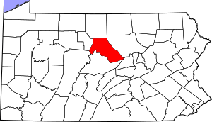
This is a list of the National Register of Historic Places listings in Clinton County, Pennsylvania.
This is intended to be a complete list of the properties and districts on the National Register of Historic Places in Clinton County, Pennsylvania, United States. The locations of National Register properties and districts for which the latitude and longitude coordinates are included below, may be seen in a map.
There are 10 properties and districts listed on the National Register in the county.
Current listings
| Name on the Register | Image | Date listed | Location | City or town | Description | |
|---|---|---|---|---|---|---|
| 1 | Farrandsville Iron Furnace |
(#91001137) |
Junction of Graham and Old Carrier Roads 41°10′29″N 77°30′52″W / 41.174722°N 77.514444°W |
Colebrook Township | ||
| 2 | Nathan Harvey House |
(#85000034) |
425–427 South Water Street 41°06′36″N 77°29′06″W / 41.11°N 77.485°W |
Mill Hall | ||
| 3 | Heisey House |
(#72001113) |
362 East Water Street 41°08′15″N 77°26′24″W / 41.1375°N 77.44°W |
Lock Haven | ||
| 4 | Logan Mills Covered Bridge |
(#79002213) |
Southwest of Loganton over Fishing Creek 41°00′20″N 77°23′11″W / 41.005556°N 77.386389°W |
Logan Township | ||
| 5 | Logan Mills Gristmill |
(#80003476) |
Off Pennsylvania Route 880 41°00′23″N 77°23′01″W / 41.006389°N 77.383611°W |
Logan Township | ||
| 6 | Memorial Park Site |
(#82003783) |
On the southern bank of the Susquehanna River near the confluence of Bald Eagle Creek 41°08′19″N 77°25′04″W / 41.1387°N 77.4179°W |
Lock Haven | ||
| 7 | Isaac A. Packer Farm |
(#91000092) |
Farrandsville Road along the West Branch of the Susquehanna River 41°09′58″N 77°28′12″W / 41.166111°N 77.47°W |
Woodward Township | ||
| 8 | Ravensburg State Park |
(#87000741) |
8 miles (13 km) southeast of Jersey Shore on Pennsylvania Route 880 41°06′16″N 77°14′34″W / 41.104444°N 77.242778°W |
Crawford Township | ||
| 9 | Rich-McCormick Woolen Factory |
(#85001959) |
Little Plum Run Road 41°10′17″N 77°22′16″W / 41.171389°N 77.371111°W |
Dunnstable Township | ||
| 10 | Water Street District |
(#73001618) |
Roughly bounded by the Susquehanna River, St. Mary's Alley, Locust Avenue, and 6th Street 41°08′17″N 77°26′58″W / 41.138056°N 77.449444°W |
Lock Haven |

All content from Kiddle encyclopedia articles (including the article images and facts) can be freely used under Attribution-ShareAlike license, unless stated otherwise. Cite this article:
National Register of Historic Places listings in Clinton County, Pennsylvania Facts for Kids. Kiddle Encyclopedia.


