
National Register of Historic Places listings in Colonial Heights, Virginia facts for kids

This is a list of the National Register of Historic Places listings in Colonial Heights, Virginia.
This is intended to be a complete list of the properties and districts on the National Register of Historic Places in the independent city of Colonial Heights, Virginia, United States. The locations of National Register properties and districts for which the latitude and longitude coordinates are included below, may be seen in a Google map.
There are 8 properties and districts listed on the National Register in the city.
Current listings
| Name on the Register | Image | Date listed | Location | Description | |
|---|---|---|---|---|---|
| 1 | Chesterfield Highlands Historic District |
 |
(#13000540) |
Roughly bounded by the Boulevard and E. Westover, Lafayette, Pickwick, Danville, and Lee Aves. 37°14′56″N 77°24′26″W / 37.248889°N 77.407222°W |
|
| 2 | Conjurer's Field Archeological Site (44CF20) |
(#90001139) |
Along the Appomattox River near the Kennon House 37°17′09″N 77°21′55″W / 37.285833°N 77.365278°W |
||
| 3 | Conjurer's Neck Archeological District |
(#03001090) |
131 Waterfront Dr. 37°17′07″N 77°21′57″W / 37.285278°N 77.365833°W |
Address is that of the Kennon House, which is included in the district | |
| 4 | Ellerslie |
 |
(#73002206) |
Ellerslie Rd. 37°16′17″N 77°24′16″W / 37.271389°N 77.404444°W |
|
| 5 | Fort Clifton Archeological Site |
|
(#81000639) |
Fort Clifton Park 37°16′52″N 77°21′56″W / 37.281111°N 77.365556°W |
Remains of a Civil War fortification |
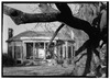
| 6 | Oak Hill |
.jpg) |
(#74002233) |
151 Carroll Ave. 37°14′13″N 77°24′33″W / 37.237083°N 77.409167°W |
|
| 7 | Violet Bank |
 |
(#74002234) |
Royal Oak Ave. 37°14′31″N 77°24′19″W / 37.241944°N 77.405139°W |
|
| 8 | Violet Bank Historic District |
 |
(#15000679) |
Lee, Lafayette, Hamilton, Cameron, Virginia, and Royal Oak Aves., and Arlington Place 37°14′34″N 77°24′21″W / 37.242778°N 77.405833°W |

All content from Kiddle encyclopedia articles (including the article images and facts) can be freely used under Attribution-ShareAlike license, unless stated otherwise. Cite this article:
National Register of Historic Places listings in Colonial Heights, Virginia Facts for Kids. Kiddle Encyclopedia.