National Register of Historic Places listings in Columbia County, Oregon facts for kids
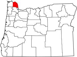
This list presents the full set of buildings, structures, objects, sites, or districts designated on the National Register of Historic Places in Columbia County, Oregon, and offers brief descriptive information about each of them. The National Register recognizes places of national, state, or local historic significance across the United States. Out of over 90,000 National Register sites nationwide, Oregon is home to over 2,000, and 13 of those are found partially or wholly in Columbia County.
Contents
Current listings
| Name on the Register | Image | Date listed | Location | City or town | Description | |
|---|---|---|---|---|---|---|
| 1 | Dr. Charles G. and Lucinda McBride Caples Farmstead |
(#05001060) |
1925 1st Street 45°53′25″N 122°48′28″W / 45.89032°N 122.8077°W |
Columbia City | ||
| 2 | Clatskanie IOOF Hall |
(#12000078) |
75 S. Nehalem Street 46°06′13″N 123°12′14″W / 46.10363333°N 123.2039611°W |
Clatskanie | ||
| 3 | Cox–Williams House |
(#82001501) |
280 S 1st Street 45°51′45″N 122°47′51″W / 45.862593°N 122.797522°W |
St. Helens | ||
| 4 | Thomas J. Flippin House |
(#79002048) |
620 Tichenor Street 46°06′03″N 123°12′28″W / 46.10074°N 123.2077°W |
Clatskanie | ||
| 5 | John and Carolena Heimuller Farmstead |
(#11000049) |
32600 SW J. P. West Road 45°45′18″N 122°53′48″W / 45.754937°N 122.896690°W |
Scappoose vicinity | ||
| 6 | Longview Bridge |
(#82004208) |
On Washington Highway 433 spanning the Columbia River 46°05′58″N 122°58′00″W / 46.09934°N 122.9667°W |
Rainier | ||
| 7 | George F. Moeck House |
(#78002283) |
713 B Street, W. 46°05′28″N 122°56′42″W / 46.09115°N 122.9451°W |
Rainier | ||
| 8 | Oregon–American Lumber Company Mill Office |
(#02001485) |
511 E Bridge Street 45°51′27″N 123°10′52″W / 45.85759°N 123.1811°W |
Vernonia | ||
| 9 | Portland and Southwestern Railroad Tunnel |
(#81000481) |
Along the Scappoose–Vernonia Highway; details of the specific location are restricted. |
Scappoose vicinity | The Portland and Southwestern Railroad's 1910–1920 construction of this timber-lined tunnel across the Nehalem Divide was an unusual step for a logging railroad, which would typically rely on less permanent infrastructure. The tunnel and rail line were abandoned in 1945 as the timber industry transitioned to log transport by truck. | |
| 10 | St. Helens Downtown Historic District |
(#84000137) |
Roughly Strand, 1st, 2nd, 3rd, Cowlitz, and St. Helens Streets, and Columbia Boulevard 45°51′50″N 122°47′56″W / 45.86388°N 122.799°W |
St. Helens | ||
| 11 | United States Post Office (Scappoose) |
(#100000618) |
52643 Columbia River Highway 45°45′34″N 122°52′43″W / 45.759357°N 122.878648°W |
Scappoose | This 1966 post office is an intact example of the facilities built by the Post Office Department in the late 1950s and the 1960s. These buildings, mostly of a modest, Modern style, mark a period in post office design between the PWA-led monumental buildings of the Great Depression and the 1971 postal reorganization. | |
| 12 | James Grant Watts House |
(#80003308) |
206 SE 1st Street 45°45′22″N 122°52′36″W / 45.75618°N 122.8767°W |
Scappoose | ||
| 13 | Woodbine Cemetery – Green Mountain Cemetery |
(#01000829) |
75900 Larson Road 46°05′56″N 122°59′52″W / 46.09894°N 122.9977°W |
Rainier vicinity |
See also
- National Register of Historic Places listings in Oregon
- Listings in neighboring counties: Clark, Clatsop, Cowlitz, Multnomah, Tillamook, Wahkiakum, Washington
- Historic preservation
- History of Oregon
- Lists of Oregon-related topics
External links
- Oregon Parks and Recreation Department, National Register Program
- National Park Service, National Register of Historic Places site

All content from Kiddle encyclopedia articles (including the article images and facts) can be freely used under Attribution-ShareAlike license, unless stated otherwise. Cite this article:
National Register of Historic Places listings in Columbia County, Oregon Facts for Kids. Kiddle Encyclopedia.


