
National Register of Historic Places listings in Comanche County, Oklahoma facts for kids

This is a list of the National Register of Historic Places listings in Comanche County, Oklahoma.
This is intended to be a complete list of the properties and districts on the National Register of Historic Places in Comanche County, Oklahoma, United States. The locations of National Register properties and districts for which the latitude and longitude coordinates are included below, may be seen in a map.
There are 36 properties and districts listed on the National Register in the county, including 1 National Historic Landmark.
Current listings
| Name on the Register | Image | Date listed | Location | City or town | Description | |
|---|---|---|---|---|---|---|
| 1 | Arrastra Site |
 |
(#81000455) |
Cedar Plantation, Wichita Mountains Wildlife Refuge 34°45′10″N 98°34′34″W / 34.75276°N 98.57603°W |
Cache | Spanish-style arrastra from the 19th Century, located at a bend in Cedar Creek. |
| 2 | Balloon Hanger at Henry Post Army Airfield |
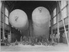 |
(#15000826) |
5037 Tucker Rd. 34°39′04″N 98°23′53″W / 34.651064°N 98.397928°W |
Fort Sill | |
| 3 | Mattie Beal House |
 |
(#75001564) |
5th St. and Summit Ave. 34°35′44″N 98°23′41″W / 34.595556°N 98.394722°W |
Lawton | |
| 4 | Blockhouse on Signal Mountain |
 |
(#78002228) |
Off Mackenzie Hill Rd. 34°40′27″N 98°29′25″W / 34.674167°N 98.490278°W |
Fort Sill | |
| 5 | Boulder Cabin |
 |
(#81000456) |
Northwest of Cache, Wichita Mountains Wildlife Refuge 34°42′06″N 98°40′30″W / 34.701667°N 98.675°W |
Cache | |
| 6 | Buffalo Lodge |
(#81000457) |
Northwest of Cache 34°44′00″N 98°42′38″W / 34.733333°N 98.710556°W |
Cache | ||
| 7 | Building 309, Fort Sill Indian School |
 |
(#73001559) |
Eastern edge of Lawton, off U.S. Route 62 34°37′23″N 98°22′51″W / 34.62312°N 98.38081°W |
Lawton | |
| 8 | Camp Comanche Site |
(#77001091) |
Address Restricted |
Fort Sill | ||
| 9 | Carnegie Library |
 |
(#76001560) |
B Ave. and 5th St. 34°36′24″N 98°23′40″W / 34.606667°N 98.394444°W |
Lawton | |
| 10 | Central Fire Station |
 |
(#16000618) |
623 SW. D Ave. 34°36′15″N 98°23′53″W / 34.604055°N 98.398035°W |
Lawton | Still in use by the Lawton Fire Department. |
| 11 | Chiefs Knoll, Fort Sill Post Cemetery |
 |
(#78002229) |
Macomb and Burrill Rds. 34°40′10″N 98°23′42″W / 34.669444°N 98.395°W |
Fort Sill | Final resting place of several indigenous chiefs of the Red River War, including Quanah Parker, Satanta, Satank, and Kicking Bird. |
| 12 | Comanche Indian Mission Cemetery |
 |
(#12000437) |
Henry Post Army Airfield, 4900 Area 34°38′32″N 98°23′33″W / 34.642318°N 98.392464°W |
Fort Sill | |
| 13 | Douglass School |
 |
(#08001148) |
102 E. Gore Boulevard 34°36′35″N 98°23′08″W / 34.60977°N 98.38551°W |
Lawton | Closed in 2011 and currently used as a Professional Development Center by the school district. |
| 14 | Federal Building and US Courthouse |
 |
(#00000243) |
410 SW Fifth St. 34°36′11″N 98°23′40″W / 34.603056°N 98.394444°W |
Lawton | |
| 15 | Ferguson House |
 |
(#81000458) |
Northwest of Cache 34°43′00″N 98°36′20″W / 34.716667°N 98.605556°W |
Cache | Former residence located within the boundaries of the Wichita Mountains Wildlife Refuge. Vacant and open for many years, it has since been boarded up to deter trespassing. |
| 16 | First Christian Church |
 |
(#85000566) |
701 D Ave. 34°36′16″N 98°23′54″W / 34.604444°N 98.398333°W |
Lawton | |
| 17 | First Presbyterian Church of Lawton |
 |
(#79001990) |
8th St. and D Ave. 34°36′13″N 98°23′58″W / 34.603611°N 98.399444°W |
Lawton | |
| 18 | First State Bank of Indiahoma |
(#80003261) |
Main St. 34°37′10″N 98°45′06″W / 34.619444°N 98.751667°W |
Indiahoma | Building no longer exists. It was razed sometime around 1981. | |
| 19 | Fort Sill |
 |
(#66000629) |
U.S. Route 62 34°40′13″N 98°23′15″W / 34.670278°N 98.3875°W |
Fort Sill | |
| 20 | General Officers Quarters |
 |
(#75001563) |
1310 Shanklin Circle 34°40′42″N 98°23′42″W / 34.678333°N 98.395°W |
Fort Sill | |
| 21 | Gore Pit District |
(#80004520) |
Straddling Gore Boulevard east of central Lawton 34°36′29″N 98°22′15″W / 34.608056°N 98.370833°W |
Lawton | ||
| 22 | Indian Cemeteries |
 |
(#77001510) |
Fort Sill Military Reservation 34°42′06″N 98°22′09″W / 34.701667°N 98.369167°W |
Fort Sill | Includes the Beef Creek Apache Cemetery, final resting place of Geronimo. |
| 23 | Ingram House |
 |
(#81000459) |
Northeast of Cache 34°43′22″N 98°36′09″W / 34.722778°N 98.6025°W |
Cache | |
| 24 | Lawton High School |
 |
(#97000197) |
809 C Ave. 34°36′21″N 98°24′01″W / 34.605833°N 98.400278°W |
Lawton | Lawton High School is no longer at this location. Building now acts as city hall. |
| 25 | Lawton National Guard Armory |
 |
(#07000519) |
600 Northwest Cache Rd. 34°37′21″N 98°23′51″W / 34.6225°N 98.3975°W |
Lawton | |
| 26 | Mahoney-Clark House |
 |
(#82001494) |
513-515 W. Gore Ave. 34°36′34″N 98°23′46″W / 34.609444°N 98.396111°W |
Lawton | |
| 27 | Medicine Bluffs |
 |
(#74001659) |
Medicine Bluff Creek 34°41′03″N 98°25′00″W / 34.684167°N 98.416667°W |
Fort Sill | Shouting "Geronimo" before a jump originates in a legend about the Apache warrior making an impossible jump from the bluffs. |
| 28 | Medicine Park Hotel and Annex |
 |
(#79001991) |
E. Lake Dr. 34°43′41″N 98°30′05″W / 34.728056°N 98.501389°W |
Medicine Park | Includes the historic Old Plantation restaurant. |
| 29 | Meers Mining Camp |
 |
(#78002230) |
20 miles (32 km) northwest of Lawton 34°46′57″N 98°34′45″W / 34.7825°N 98.579167°W |
Lawton | Former mining town, reduced to a rural neighborhood outside the Wichita Mountains. The Meers Store & Restaurant is still open, and noted for its hamburgers. |
| 30 | Methodist Episcopal Church, South |
 |
(#85000567) |
702 D Ave. 34°36′14″N 98°23′54″W / 34.603889°N 98.398333°W |
Lawton | |
| 31 | Old Tower Two |
 |
(#74001660) |
Northwest of Lawton at the junction of Signal Mountain and Tower Two Rds. 34°40′24″N 98°26′48″W / 34.673333°N 98.446667°W |
Fort Sill | Old observation tower used by Field Artillerymen on Fort Sill from 1911-1918. |
| 32 | Quanah Parker Star House |
 |
(#70000532) |
Eagle Park 34°37′42″N 98°38′34″W / 34.628333°N 98.642778°W |
Cache | Former home of Comanche Chief Quanah Parker. Moved from its original location, it now resides on the side of the long-closed Eagle Park, and is open only by appointment. |
| 33 | Penateka |
 |
(#76001559) |
3.5 miles west of Elgin on U.S. Route 277 34°46′48″N 98°22′09″W / 34.78006°N 98.36917°W |
Elgin | |
| 34 | Henry Post Air Field |
 |
(#78002231) |
North of Lawton on Fort Sill 34°38′40″N 98°23′47″W / 34.644444°N 98.396389°W |
Fort Sill |

All content from Kiddle encyclopedia articles (including the article images and facts) can be freely used under Attribution-ShareAlike license, unless stated otherwise. Cite this article:
National Register of Historic Places listings in Comanche County, Oklahoma Facts for Kids. Kiddle Encyclopedia.