National Register of Historic Places listings in Costilla County, Colorado facts for kids
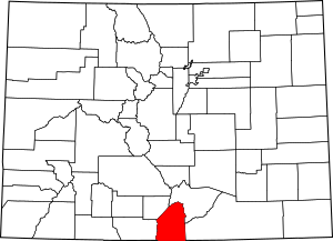
This is a list of the National Register of Historic Places listings in Costilla County, Colorado.
This is intended to be a complete list of the properties and districts on the National Register of Historic Places in Costilla County, Colorado, United States. The locations of National Register properties and districts for which the latitude and longitude coordinates are included below, may be seen in a map.
There are 12 properties and districts listed on the National Register in the county. Another property was once listed but has been removed.
| Adams - Alamosa - Arapahoe - Archuleta - Baca - Bent - Boulder - Broomfield - Chaffee - Cheyenne - Clear Creek - Conejos - Costilla - Crowley - Custer - Delta - Denver - Dolores - Douglas - Eagle - El Paso - Elbert - Fremont - Garfield - Gilpin - Grand - Gunnison - Hinsdale - Huerfano - Jackson - Jefferson - Kiowa - Kit Carson - La Plata - Lake - Larimer - Las Animas - Lincoln - Logan - Mesa - Mineral - Moffat - Montezuma - Montrose - Morgan - Otero - Ouray - Park - Phillips - Pitkin - Prowers - Pueblo - Rio Blanco - Rio Grande - Routt - Saguache - San Juan - San Miguel - Sedgwick - Summit - Teller - Washington - Weld - Yuma |
Current listings
| Name on the Register | Image | Date listed | Location | City or town | Description | |
|---|---|---|---|---|---|---|
| 1 | Capilla de San Isidro |
(#13000523) |
21801 County Road K5 37°08′05″N 105°22′49″W / 37.134845°N 105.38027°W |
Los Fuertes | ||
| 2 | Capilla de Viejo San Acacio |
(#12000091) |
14152 County Road 14.8 37°12′06″N 105°30′31″W / 37.2018°N 105.5085°W |
Viejo San Acacio | Culebra River Villages of Costilla County Multiple Property Submission | |
| 3 | Fort Garland |
(#70000156) |
On State Highway 159, 1 block south of U.S. Highway 160 37°25′18″N 105°25′50″W / 37.421667°N 105.430556°W |
Fort Garland | ||
| 4 | Iglesia de la Inmaculada Concepcion |
(#12000089) |
21529 County Road P.6 37°09′48″N 105°22′55″W / 37.1633°N 105.3819°W |
Chama | Culebra River Villages of Costilla County Multiple Property Submission | |
| 5 | Iglesia de San Francisco de Assisi |
(#12000144) |
23531 County Road J.2 37°06′09″N 105°20′57″W / 37.1024°N 105.3493°W |
San Francisco | Culebra River Villages of Costilla County Multiple Property Submission | |
| 6 | Iglesia de San Pedro y San Pablo |
(#12000090) |
11423 County Road 21 37°09′41″N 105°24′07″W / 37.161313°N 105.401808°W |
San Pedro | Culebra River Villages of Costilla County Multiple Property Submission | |
| 7 | Plaza de San Luis de la Culebra |
(#78000837) |
State Highway 159 37°11′14″N 105°25′25″W / 37.187222°N 105.423611°W |
San Luis | ||
| 8 | Rito Seco Creek Culvert |
(#02001146) |
State Highway 142 at milepost 33.81 37°12′00″N 105°25′34″W / 37.2°N 105.426111°W |
San Luis | ||
| 9 | A. A. Salazar House |
(#97001281) |
603 Main St. 37°12′08″N 105°25′31″W / 37.202222°N 105.425278°W |
San Luis | ||
| 10 | San Luis Bridge |
(#85000195) |
Off State Highway 159 37°11′37″N 105°25′49″W / 37.193611°N 105.430278°W |
San Luis | ||
| 11 | San Luis Southern Railway Trestle |
(#03001361) |
An abandoned section of Costilla County Road 12 37°23′12″N 105°32′51″W / 37.386667°N 105.5475°W |
Blanca |
Former listing
| Name on the Register | Image | Date listed | Date removed | Location | City or town | Summary | |
|---|---|---|---|---|---|---|---|
| 1 | Smith-Gallego House |
(#7500504) |
|
Main St. |
San Luis | Demolished in June 1982 |

All content from Kiddle encyclopedia articles (including the article images and facts) can be freely used under Attribution-ShareAlike license, unless stated otherwise. Cite this article:
National Register of Historic Places listings in Costilla County, Colorado Facts for Kids. Kiddle Encyclopedia.


