
National Register of Historic Places listings in Crawford County, Iowa facts for kids

This is a list of the National Register of Historic Places listings in Crawford County, Iowa.
This is intended to be a complete list of the properties and districts on the National Register of Historic Places in Crawford County, Iowa, United States. Latitude and longitude coordinates are provided for many National Register properties and districts; these locations may be seen together in a map.
There are 12 properties listed on the National Register in the county.
| Name on the Register | Image | Date listed | Location | City or town | Description | |
|---|---|---|---|---|---|---|
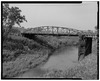
| 1 | Buck Grove Bridge |
(#98000797) |
Buck Creek Ave. over Buck Creek 41°54′50″N 95°22′49″W / 41.913889°N 95.380278°W |
Buck Grove | ||
| 2 | John T. and Marietta (Greek) Carey House |
 |
(#05000276) |
1502 1st Ave., N. 42°01′03″N 95°21′06″W / 42.0175°N 95.351667°W |
Denison | Designed by architect George Franklin Barber |
| 3 | Clarence D. Chamberlin House |
 |
(#77000505) |
1434 2nd Ave., S. 42°00′53″N 95°21′07″W / 42.014722°N 95.351944°W |
Denison | |
| 4 | Crawford County Courthouse |
 |
(#81000232) |
Broadway between Ave. B and Ave. C 42°01′01″N 95°21′24″W / 42.016852°N 95.356587°W |
Denison | |
| 5 | Dow House |
 |
(#72000471) |
Prince St. at the southern city limit 41°55′30″N 95°29′50″W / 41.925°N 95.497222°W |
Dow City | |
| 6 | Z.T. Dunham Pioneer Stock Farm |
(#93000652) |
Iowa Highway 37, 1 mile northwest of Dunlap 41°52′03″N 95°37′09″W / 41.8675°N 95.619167°W |
Dunlap | ||
| 7 | Klondike Hotel |
(#96001060) |
332 3rd St. 41°53′26″N 95°14′03″W / 41.890556°N 95.234167°W |
Manilla | ||
| 8 | William A. McHenry House |
 |
(#76000755) |
1428 1st Ave., N. 42°01′05″N 95°21′07″W / 42.018056°N 95.351944°W |
Denison | |
| 9 | Nishnabotna River Bridge |
 |
(#99000309) |
310th St. between X and Y Aves. 41°52′00″N 95°16′00″W / 41.866667°N 95.266667°W |
Manilla | |
| 10 | Nishnabotna River Bridge |
 |
(#98000801) |
T Ave. over the Nishnabotna River 41°56′08″N 95°13′08″W / 41.935556°N 95.218889°W |
Manilla | |
| 11 | Park Motel |
 |
(#00000565) |
803 4th Ave. S. 42°00′43″N 95°21′45″W / 42.011944°N 95.3625°W |
Denison | |
| 12 | Yellow Smoke Park Bridge |
(#98000800) |
Pedestrian path over an unnamed stream 42°01′36″N 95°19′05″W / 42.026667°N 95.318056°W |
Denison |

All content from Kiddle encyclopedia articles (including the article images and facts) can be freely used under Attribution-ShareAlike license, unless stated otherwise. Cite this article:
National Register of Historic Places listings in Crawford County, Iowa Facts for Kids. Kiddle Encyclopedia.