
National Register of Historic Places listings in Crawford County, Pennsylvania facts for kids

This is a list of the National Register of Historic Places listings in Crawford County, Pennsylvania.
This is intended to be a complete list of the properties and districts on the National Register of Historic Places in Crawford County, Pennsylvania, United States. The locations of National Register properties and districts for which the latitude and longitude coordinates are included below, may be seen in a map.
There are 19 properties and districts listed on the National Register in the county.
Contents
Current listings
| Name on the Register | Image | Date listed | Location | City or town | Description | |
|---|---|---|---|---|---|---|
| 1 | Baldwin-Reynolds House |
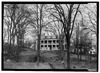 |
(#74001777) |
Terrace Street 41°38′52″N 80°09′07″W / 41.647778°N 80.151944°W |
Meadville | |
| 2 | Bentley Hall |
 |
(#77001156) |
Allegheny College campus 41°38′55″N 80°08′51″W / 41.648611°N 80.1475°W |
Meadville | |
| 3 | Bridge in East Fallowfield Township |
 |
(#88000825) |
Legislative Route 20012 over Unger Run 41°32′06″N 80°20′12″W / 41.535000°N 80.336667°W |
East Fallowfield Township | |
| 4 | Bridge in Oil Creek Township |
 |
(#88000833) |
State Route 2020 over Oil Creek 41°37′45″N 79°42′10″W / 41.629167°N 79.702778°W |
Oil Creek Township | Removed from site. |
| 5 | Bridge in Rockdale Township |
 |
(#88000829) |
Legislative Route 20076 over French Creek 41°48′38″N 79°59′02″W / 41.810417°N 79.983889°W |
Rockdale Township | |
| 6 | Bridge in West Mead Township |
 |
(#88000827) |
Legislative Route 20027 over French Creek 41°35′21″N 80°09′02″W / 41.589167°N 80.150556°W |
West Mead Township | |
| 7 | John Brown Tannery Site |
 |
(#78002383) |
500 feet south of the junction of Pennsylvania Route 77 and John Brown Road 41°43′09″N 79°57′04″W / 41.719167°N 79.951111°W |
Richmond Township | Only the foundation remains after a fire in 1907 |
| 8 | Cambridge Springs Bridge |
 |
(#88000824) |
Legislative Route 84 spur B over French Creek 41°48′23″N 80°03′41″W / 41.806389°N 80.061389°W |
Cambridge Springs | |
| 9 | Independent Congregational Church |
 |
(#78002381) |
346 Chestnut Street 41°38′14″N 80°09′01″W / 41.637222°N 80.150278°W |
Meadville | |
| 10 | Amos Kelly House |
 |
(#80003477) |
325 South Main Street 41°48′06″N 80°03′32″W / 41.801667°N 80.058889°W |
Cambridge Springs | |
| 11 | Meadville Downtown Historic District |
 |
(#84000023) |
Roughly bounded by Chancery Lane, Mulberry, Walnut and Chestnut Streets 41°38′20″N 80°09′04″W / 41.638889°N 80.151111°W |
Meadville | |
| 12 | Dr. J.R. Mosier Office |
 |
(#77001157) |
Terrace Street 41°38′47″N 80°09′08″W / 41.646389°N 80.152222°W |
Meadville | |
| 13 | Riverside Hotel |
 |
(#78002380) |
1 Fountain Street 41°48′21″N 80°03′12″W / 41.80575°N 80.053333°W |
Cambridge Springs | |
| 14 | Roueche House |
 |
(#82003784) |
762 Park Avenue 41°38′33″N 80°09′04″W / 41.642500°N 80.151111°W |
Meadville | |
| 15 | Ruter Hall |
 |
(#78002382) |
North Main Street on Allegheny College campus 41°38′54″N 80°08′46″W / 41.648333°N 80.146111°W |
Meadville | |
| 16 | Edward Saeger House |
 |
(#80003479) |
375 Main Street 41°43′07″N 80°08′53″W / 41.718611°N 80.148056°W |
Saegertown | |
| 17 | Judge Henry Shippen House |
 |
(#84003339) |
403 Chestnut Street 41°38′14″N 80°08′52″W / 41.637222°N 80.147778°W |
Meadville | |
| 18 | Titusville City Hall |
 |
(#75001635) |
107 North Franklin Street 41°37′39″N 79°40′25″W / 41.627417°N 79.673694°W |
Titusville | |
| 19 | Titusville Historic District |
.jpg) |
(#85000178) |
Roughly bounded by Petroleum, Spruce, Franklin, Perry, Monroe, Main and Spring Streets 41°37′47″N 79°40′26″W / 41.629722°N 79.673889°W |
Titusville |
Former listings
| Name on the Register | Image | Date listed | Date removed | Location | City or town | Summary | |
|---|---|---|---|---|---|---|---|
| 1 | Shadeland |
(#83002230) |
|
North of Springboro on Pennsylvania Route 18 |
Springboro | ||
| 2 | Dr. James White House |
(#80003478) |
|
Junction of U.S. Route 322 and Pennsylvania Route 285 |
Hartstown |

All content from Kiddle encyclopedia articles (including the article images and facts) can be freely used under Attribution-ShareAlike license, unless stated otherwise. Cite this article:
National Register of Historic Places listings in Crawford County, Pennsylvania Facts for Kids. Kiddle Encyclopedia.