National Register of Historic Places listings in Dillingham Census Area, Alaska facts for kids
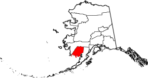
This is a list of the National Register of Historic Places listings in Dillingham Census Area, Alaska.
This is intended to be a complete list of the properties and districts on the National Register of Historic Places in Dillingham Census Area, Alaska, United States. The locations of National Register properties and districts for which the latitude and longitude coordinates are included below, may be seen in a Google map.
There are 3 properties and districts listed on the National Register in the census area, including one National Historic Landmark District. Another property was once listed but has been delisted.
Current listings
| Name on the Register | Image | Date listed | Location | City or town | Description | |
|---|---|---|---|---|---|---|
| 1 | St. Nicholas Chapel |
(#80000749) |
In Ekuk 58°47′53″N 158°32′54″W / 58.798056°N 158.548333°W |
Ekuk | ||
| 2 | Transfiguration of Our Lord Chapel |
(#80000752) |
In Nushagak 58°56′54″N 158°29′21″W / 58.948333°N 158.489167°W |
Nushagak | ||
| 3 | Walrus Islands Archeological District |
(#100000875) |
mouth of Bristol Bay 58°36′42″N 159°59′27″W / 58.611633°N 159.990909°W |
Togiak |
Former listings
| Name on the Register | Image | Date listed | Date removed | Location | City or town | Summary | |
|---|---|---|---|---|---|---|---|
| 1 | Fishermen's Co-op |
(#95000400) |
|
247 Main St. |
Dillingham |

All content from Kiddle encyclopedia articles (including the article images and facts) can be freely used under Attribution-ShareAlike license, unless stated otherwise. Cite this article:
National Register of Historic Places listings in Dillingham Census Area, Alaska Facts for Kids. Kiddle Encyclopedia.


