National Register of Historic Places listings in Gloucester County, Virginia facts for kids
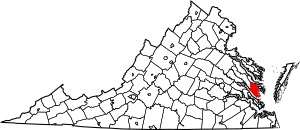
This is a list of the National Register of Historic Places listings in Gloucester County, Virginia.
This is intended to be a complete list of the properties and districts on the National Register of Historic Places in Gloucester County, Virginia, United States. The locations of National Register properties and districts for which the latitude and longitude coordinates are included below, may be seen in an online map.
There are 34 properties and districts listed on the National Register in the county, including 1 National Historic Landmark.
Current listings
| Name on the Register | Image | Date listed | Location | City or town | Description | |
|---|---|---|---|---|---|---|
| 1 | Abingdon Church |
(#70000796) |
U.S. 17, S of jct. with VA 614 37°20′01″N 76°30′48″W / 37.333611°N 76.513333°W |
White Marsh | ||
| 2 | Abingdon Glebe House |
(#70000794) |
S of jct. of U.S. 17 and VA 615 37°22′38″N 76°32′26″W / 37.377222°N 76.540556°W |
Gloucester | ||
| 3 | Airville |
(#90001824) |
VA 629 S of jct. with VA 626 37°23′14″N 76°30′13″W / 37.387222°N 76.503611°W |
Gloucester | ||
| 4 | Burgh Westra |
(#76002107) |
E of Gloucester off VA 3 37°25′11″N 76°27′12″W / 37.419722°N 76.453472°W |
Gloucester | ||
| 5 | Cappahosic House |
(#03000211) |
3198 Cappahosic Rd. 37°22′51″N 76°37′59″W / 37.380833°N 76.633056°W |
Gloucester | ||
| 6 | Fairfield Site |
(#73002019) |
North of the York River 37°20′28″N 76°33′14″W / 37.341111°N 76.553889°W |
White Marsh | Faced Carter's Creek until its destruction by fire circa 1900 | |
| 7 | Gloucester County Courthouse Square Historic District |
(#73002016) |
Main St. and Gloucester County Courthouse Sq. 37°24′53″N 76°31′47″W / 37.414722°N 76.529722°W |
Gloucester | ||
| 8 | Gloucester Downtown Historic District |
(#10001063) |
Seven blocks of Main St. from the courthouse circle to Ware House Rd. 37°24′48″N 76°31′26″W / 37.413333°N 76.523889°W |
Gloucester | ||
| 9 | Gloucester Point Archaeological District |
(#85001251) |
Off U.S. Route 13 on Gloucester Point 37°15′00″N 76°30′00″W / 37.250000°N 76.500000°W |
Gloucester | ||
| 10 | Gloucester Women's Club |
(#74002117) |
On U.S. 17 37°24′45″N 76°31′10″W / 37.412500°N 76.519444°W |
Gloucester | ||
| 11 | Hockley |
(#10000446) |
6640 Ware Neck Rd. 37°23′51″N 76°27′55″W / 37.397500°N 76.465278°W |
Gloucester | ||
| 12 | Holly Knoll |
(#81000640) |
Off RR 662 37°23′16″N 76°38′38″W / 37.387778°N 76.643889°W |
Capahosic | Home of Robert R. Moton | |
| 13 | Kempsville |
(#78003018) |
E of Shacklefords on VA 33 37°33′44″N 76°38′22″W / 37.562222°N 76.639444°W |
Shacklefords | ||
| 14 | Kenwood |
(#15000251) |
7437 Kenwood Ln. 37°25′02″N 76°33′15″W / 37.417222°N 76.554167°W |
Gloucester | ||
| 15 | Lands End |
(#74002118) |
SE of Naxera on VA 614 37°19′35″N 76°25′31″W / 37.326389°N 76.425278°W |
Naxera | ||
| 16 | Little England |
(#70000795) |
E of Gloucester on VA 672 37°15′14″N 76°28′45″W / 37.253889°N 76.479167°W |
Gloucester | ||
| 17 | Lowland Cottage |
(#71001104) |
SW of Ware Neck, 0.5 mi. S of VA 623 37°23′49″N 76°28′02″W / 37.396806°N 76.467222°W |
Ware Neck | ||
| 18 | Point Lookout Archaeological Site |
(#14000234) |
Mobjack Rd. 37°21′03″N 76°26′23″W / 37.350833°N 76.439722°W |
White Marsh | ||
| 19 | Walter Reed Birthplace |
(#73002017) |
SW of Gloucester at jct. of VA 614 and 616; 4021 Hickory Fork Rd. 37°23′18″N 76°35′17″W / 37.388472°N 76.588194°W |
Belroi | Hickory Fork Rd. address represents a boundary increase, December 15, 2015. | |
| 20 | Roaring Spring |
(#72001395) |
0.3 mi. E of VA 616 37°26′00″N 76°31′27″W / 37.433472°N 76.524028°W |
Gloucester | ||
| 21 | Rosewell |
(#69000244) |
5113 Old Rosewell Lane 37°19′41″N 76°34′34″W / 37.327917°N 76.576111°W |
Gloucester | ||
| 22 | Shelly Archeological District |
(#89001932) |
York River 37°19′20″N 76°34′00″W / 37.322222°N 76.566667°W |
Hayes | ||
| 23 | Site 44GL103-Quest End |
(#08000387) |
5488 & 5476 Roanes Wharf Rd. 37°21′46″N 76°28′11″W / 37.362778°N 76.469722°W |
Selden | ||
| 24 | Timberneck |
(#79003041) |
E of Wicomico off VA 635 37°17′51″N 76°32′09″W / 37.297500°N 76.535833°W |
Wicomico | ||
| 25 | Toddsbury |
(#69000245) |
E of jct. of Rtes. 662 and 14 37°26′05″N 76°27′05″W / 37.434722°N 76.451389°W |
Gloucester | ||
| 26 | T.C. Walker House |
(#09001050) |
1 Main St. 37°24′47″N 76°31′19″W / 37.413111°N 76.521944°W |
Gloucester | ||
| 27 | Ware Neck Store and Post Office |
(#09000393) |
6495 VA 629 37°24′10″N 76°27′32″W / 37.402778°N 76.458750°W |
Ware Neck | ||
| 28 | Ware Parish Church |
(#73002018) |
NE of Gloucester on VA 14 37°25′21″N 76°30′27″W / 37.4225°N 76.5075°W |
Gloucester | ||
| 29 | Warner Hall |
(#80004191) |
VA 629 37°20′26″N 76°28′33″W / 37.340556°N 76.475833°W |
Gloucester | ||
| 30 | Werowocomoco Archeological Site |
(#06000138) |
3051 Ginny Hill Rd. 37°24′38″N 76°39′20″W / 37.410556°N 76.655556°W |
Gloucester | ||
| 31 | White Hall |
(#84003540) |
VA 668 37°22′11″N 76°28′16″W / 37.369722°N 76.471111°W |
Zanoni | ||
| 32 | Woodville School |
(#04000042) |
4310 George Washington Memorial Highway 37°19′30″N 76°30′54″W / 37.325000°N 76.515000°W |
Ordinary | ||
| 33 | Zion Poplars Baptist Church |
(#99000970) |
7000 T.C. Walker Rd. 37°23′58″N 76°30′33″W / 37.399306°N 76.509167°W |
Gloucester |

All content from Kiddle encyclopedia articles (including the article images and facts) can be freely used under Attribution-ShareAlike license, unless stated otherwise. Cite this article:
National Register of Historic Places listings in Gloucester County, Virginia Facts for Kids. Kiddle Encyclopedia.


