National Register of Historic Places listings in Halifax County, Virginia facts for kids
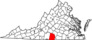
This is a list of the National Register of Historic Places listings in Halifax County, Virginia.
This is intended to be a complete list of the properties and districts on the National Register of Historic Places in Halifax County, Virginia, United States. The locations of National Register properties and districts for which the latitude and longitude coordinates are included below, may be seen in an online map.
There are 38 properties and districts listed on the National Register in the county, including 1 National Historic Landmark.
Current listings
| Name on the Register | Image | Date listed | Location | City or town | Description | |
|---|---|---|---|---|---|---|
| 1 | Berry Hill |
(#69000246) |
S of jct. of Rtes. 659 and 682 36°41′55″N 78°56′38″W / 36.698611°N 78.943889°W |
South Boston | ||
| 2 | Black Walnut |
(#91001597) |
VA 600, 850 ft. S of jct. with VA 778 36°51′49″N 78°43′20″W / 36.863611°N 78.722222°W |
Clover | ||
| 3 | Brandon Plantation |
(#96000495) |
VA 697, 500 ft. W of jct. with VA 696 36°34′38″N 79°07′19″W / 36.577222°N 79.121861°W |
Alton | ||
| 4 | Brooklyn Store and Post Office |
(#95001557) |
VA 659 N side, 0.1 mi. W of jct. with VA 820 36°40′38″N 79°09′05″W / 36.677222°N 79.151250°W |
Brooklyn | ||
| 5 | Brooklyn Tobacco Factory |
(#95001559) |
VA 659 N side, 0.25 mi. E of jct. with VA 820 36°40′45″N 79°08′42″W / 36.679167°N 79.145000°W |
Brooklyn | ||
| 6 | Buckshoal Farm |
(#87001473) |
VA 737 36°38′34″N 78°46′14″W / 36.642639°N 78.770556°W |
Omega | ||
| 7 | Carlbrook |
(#00000556) |
VA 663, jct. VA 684 36°43′42″N 79°08′10″W / 36.728333°N 79.136111°W |
Halifax | ||
| 8 | Carter's Tavern |
(#74002120) |
SE of Ingram 36°40′31″N 79°08′03″W / 36.675278°N 79.134167°W |
Paces | ||
| 9 | Clarkton Bridge |
(#06000747) |
Clarkton Bridge Rd. over the Staunton River 36°58′40″N 78°53′49″W / 36.977778°N 78.896944°W |
Nathalie | Extends into Charlotte County | |
| 10 | Collins Ferry Historic District |
(#12000986) |
McKeever Trail, & Bull Creek Rd. 37°02′19″N 79°02′23″W / 37.038611°N 79.039722°W |
Nathalie | ||
| 11 | The Cove |
(#06000407) |
5059 Cove Rd. 36°58′57″N 78°44′40″W / 36.982500°N 78.744444°W |
Harrisburg | ||
| 12 | DeJarnette's Tavern |
(#07000398) |
4080 Stagecoach Rd. 37°00′48″N 79°00′21″W / 37.013333°N 79.005833°W |
Nathalie | Late 18th century stagecoach station and tavern. | |
| 13 | E. L. Evans House |
(#08000388) |
1204 Washington Ave. 36°42′16″N 78°54′02″W / 36.704444°N 78.900556°W |
South Boston | ||
| 14 | Fourqurean House |
(#80004192) |
2.4 mi. SW of South Boston 36°39′20″N 78°56′28″W / 36.655556°N 78.941111°W |
South Boston | ||
| 15 | Glennmary |
(#79003043) |
SW of South Boston on U.S. 58 36°40′49″N 78°55′58″W / 36.680139°N 78.932778°W |
South Boston | ||
| 16 | Halifax County Courthouse |
(#82004563) |
Jct. US 360 and US 501 36°45′56″N 78°55′46″W / 36.765556°N 78.929444°W |
Halifax | ||
| 17 | Indian Jim's Cave |
(#82004562) |
Address Restricted |
Brookneal | ||
| 18 | Mountain Road Historic District |
(#83004245) |
Roughly Mountain Rd. from Mimosa Dr. to Academy St.; also Mountain Rd., Academy St., and Poplar Ln. 36°46′03″N 78°56′03″W / 36.767500°N 78.934167°W |
Halifax | Second set of boundaries represents a boundary increase of August 24, 2015 | |
| 19 | Old Providence Presbyterian Church |
(#88001013) |
VA 624 36°56′16″N 78°49′10″W / 36.937778°N 78.819444°W |
Providence | ||
| 20 | Pleasant Grove |
(#99000966) |
Deer Run Rd. 36°43′30″N 79°02′55″W / 36.725000°N 79.048611°W |
Halifax | ||
| 21 | Redfield |
(#78003020) |
3 mi. SE of Oak Level on VA 683 36°42′02″N 79°04′39″W / 36.700556°N 79.077500°W |
Oak Level | ||
| 22 | Reedy Creek Site |
(#78003187) |
Address Restricted |
South Boston | ||
| 23 | Seaton |
(#80004193) |
N of South Boston on U.S. 501 36°44′41″N 78°55′22″W / 36.744722°N 78.922778°W |
South Boston | ||
| 24 | South Boston Historic District |
(#86002471) |
Along Railroad Ave., Ferry, Factory, and Main Sts., Wilborn Ave., N. Main St., Washington and Peach Aves., and Jeffress; also neighborhoods of Marshall Ave., New Brick Warehouse, Mizpah Church, N. Main St. 36°41′51″N 78°54′05″W / 36.697500°N 78.901389°W |
South Boston | Second set of boundaries represents a boundary increase of June 11, 2009 | |
| 25 | Staunton River Bridge Fortification |
(#04000577) |
Address Restricted 36°52′53″N 78°42′05″W / 36.8815°N 78.7015°W |
Randolph | In or near Staunton River Battlefield State Park. | |
| 26 | Staunton River State Park Historic District |
(#07000402) |
1170 Staunton Trail 36°41′58″N 78°40′04″W / 36.699444°N 78.667778°W |
Scottsburg | ||
| 27 | Tarover |
(#78003021) |
West of South Boston on VA 659 36°42′02″N 78°57′54″W / 36.700694°N 78.965000°W |
South Boston | ||
| 28 | Dr. Richard Thornton House |
(#12000987) |
Golden Leaf and Tobacco Rds. 36°58′38″N 79°01′58″W / 36.977222°N 79.032778°W |
Nathalie | ||
| 29 | Town of Halifax Court House Historic District |
(#10001187) |
Main St., Cemetery St., Prizery St., Edmunds Boulevard, Mary Bethune St., Cowford Rd., Maple Ave., Church St., Cary St. 36°45′58″N 78°55′43″W / 36.766111°N 78.928611°W |
Halifax |

All content from Kiddle encyclopedia articles (including the article images and facts) can be freely used under Attribution-ShareAlike license, unless stated otherwise. Cite this article:
National Register of Historic Places listings in Halifax County, Virginia Facts for Kids. Kiddle Encyclopedia.


