National Register of Historic Places listings in Lincoln County, Nebraska facts for kids
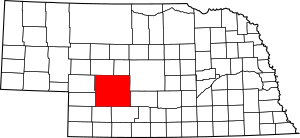
This is a list of the National Register of Historic Places listings in Lincoln County, Nebraska. It is intended to be a complete list of the properties and districts on the National Register of Historic Places in Lincoln County, Nebraska, United States. The locations of National Register properties and districts for which the latitude and longitude coordinates are included below, may be seen in a map.
There are 10 properties and districts listed on the National Register in the county, one of which is a National Historic Landmark.
Current listings
| Name on the Register | Image | Date listed | Location | City or town | Description | |
|---|---|---|---|---|---|---|
| 1 | Fort McPherson National Cemetery |
(#12000075) |
12004 S. Spur 56A 41°01′32″N 100°31′30″W / 41.025686°N 100.525022°W |
Maxwell vicinity | ||
| 2 | Fox Theatre |
(#85000957) |
301 E. 5th 41°08′14″N 100°45′36″W / 41.137222°N 100.76°W |
North Platte | ||
| 3 | Hotel Yancey |
(#85000956) |
221 E. 5th St. 41°08′15″N 100°45′37″W / 41.1375°N 100.760278°W |
North Platte | ||
| 4 | Johnston Memorial Building |
(#86000473) |
Off Nebraska Highway 25 40°50′22″N 101°09′52″W / 40.839444°N 101.164444°W |
Wallace | ||
| 5 | Lincoln County Courthouse |
(#89002224) |
Dewey St. between 3rd and 4th Sts. 41°08′10″N 100°45′45″W / 41.136111°N 100.7625°W |
North Platte | ||
| 6 | North Platte US Post Office and Federal Building |
(#09000071) |
416 North Jeffers Street 41°08′12″N 100°45′48″W / 41.136703°N 100.763247°W |
North Platte | ||
| 7 | O'Fallons Bluff |
(#74001127) |
Southeast of Sutherland 41°08′11″N 101°05′41″W / 41.136389°N 101.094722°W |
Sutherland | ||
| 8 | Scout's Rest Ranch |
(#78001705) |
Northwest of North Platte off U.S. Route 30 41°09′48″N 100°47′42″W / 41.163333°N 100.795°W |
North Platte | ||
| 9 | Sutherland State Aid Bridge |
(#92000705) |
County road over the North Platte River, 4.2 miles (6.8 km) north of Sutherland 41°12′36″N 101°07′02″W / 41.21°N 101.117222°W |
Sutherland |

All content from Kiddle encyclopedia articles (including the article images and facts) can be freely used under Attribution-ShareAlike license, unless stated otherwise. Cite this article:
National Register of Historic Places listings in Lincoln County, Nebraska Facts for Kids. Kiddle Encyclopedia.


