National Register of Historic Places listings in Matanuska-Susitna Borough, Alaska facts for kids
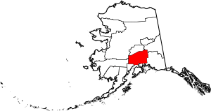
This is a list of the National Register of Historic Places listings in Matanuska-Susitna Borough, Alaska.
This is intended to be a complete list of the properties and districts on the National Register of Historic Places in Matanuska-Susitna Borough, Alaska, United States. The locations of National Register properties and districts for which the latitude and longitude coordinates are included below, may be seen in an online map.
There are 30 properties and districts listed on the National Register in the borough.
Current listings
| Name on the Register | Image | Date listed | Location | City or town | Description | |
|---|---|---|---|---|---|---|
| 1 | Bailey Colony Farm |
(#91000775) |
3150 N. Glenn Highway 61°36′59″N 149°07′02″W / 61.616389°N 149.117222°W |
Palmer | ||
| 2 | Berry House |
(#91000779) |
5805 N. Farm Loop Rd. 61°38′45″N 149°08′45″W / 61.645833°N 149.145833°W |
Palmer | ||
| 3 | Campbell House |
(#13000129) |
1540 Inner Springer Loop 61°34′14″N 149°07′39″W / 61.5706°N 149.1275°W |
Palmer | Settlement and Economic Development of Alaska's Matanuska-Susitna Valley MPS | |
| 4 | Cunningham-Hall Pt-6, Nc-692W |
(#78000531) |
In the collection of the Alaska Museum of Transportation and Industry 61°34′48″N 149°07′49″W / 61.58°N 149.130278°W |
Wasilla | ||
| 5 | Curry Lookout |
(#92000424) |
Atop Curry Ridge, mile 137.2 on the Parks Highway 62°37′23″N 150°05′44″W / 62.623056°N 150.095556°W |
Talkeetna | ||
| 6 | Fairview Inn |
(#82004905) |
Main St. 62°19′25″N 150°06′40″W / 62.323611°N 150.111111°W |
Talkeetna | ||
| 7 | Herried House |
(#91000778) |
4400 N. Palmer-Fishook Highway 61°38′15″N 149°10′06″W / 61.6375°N 149.168333°W |
Palmer | ||
| 8 | Hyland Hotel |
(#91000774) |
333 W. Evergreen 61°36′03″N 149°06′13″W / 61.600833°N 149.103611°W |
Palmer | ||
| 9 | Independence Mines |
(#74000440) |
West of Palmer 61°47′42″N 149°16′57″W / 61.795°N 149.2825°W |
Palmer | ||
| 10 | Kirsch's Place |
(#97001631) |
Mile 1.5 on Sunshine Rd. or mile 215.3 on the Alaska Railroad 62°10′03″N 150°04′21″W / 62.1675°N 150.0725°W |
Talkeetna | ||
| 11 | Knik Site |
(#73000379) |
About 15 miles southwest of Wasilla on Knik Rd. 61°27′29″N 149°43′41″W / 61.458056°N 149.728056°W |
Wasilla | ||
| 12 | Matanuska Colony Community Center |
(#91000773) |
Roughly bounded by S. Colony, E. Firewood, S. Eklutua, E. Elmwood, S. Denali, and a line north of properties on E. Dahlia 61°36′06″N 149°06′30″W / 61.601667°N 149.108333°W |
Palmer | ||
| 13 | Palmer Depot |
(#78000530) |
South Valley Way and Evergreen Ave. 61°36′24″N 149°06′34″W / 61.606667°N 149.109444°W |
Palmer | ||
| 14 | Patten Colony Farm |
(#91000776) |
Mile 39.9 on the Glenn Highway across from State Fairground 61°34′49″N 149°08′20″W / 61.580278°N 149.138889°W |
Palmer | ||
| 15 | Puhl House |
(#91000777) |
13151 E. Scott Rd. 61°36′40″N 149°08′03″W / 61.611111°N 149.134167°W |
Palmer | ||
| 16 | Raymond Rebarchek Colony Farm |
(#78000532) |
South of Palmer off the Glenn Highway 61°34′39″N 149°07′38″W / 61.5775°N 149.127222°W |
Palmer | ||
| 17 | Sutton Community Hall |
(#13000617) |
Jonesville Road, just north of Glenn Highway 61°42′40″N 148°53′48″W / 61.7112°N 148.8968°W |
Sutton | ||
| 18 | Talkeetna Airstrip |
(#02000814) |
Roughly from 1st St. south down D St. to the Susitna River 62°19′17″N 150°06′39″W / 62.321389°N 150.110833°W |
Talkeetna | ||
| 19 | Talkeetna Historic District |
(#93000321) |
Roughly bounded by C, 1st, D, and Front Sts. 62°19′24″N 150°06′43″W / 62.323333°N 150.111944°W |
Talkeetna | ||
| 20 | Tangle Lakes Archeological District |
(#71001091) |
Address Restricted |
Glennallen | ||
| 21 | Teeland's Country Store |
(#78000533) |
Mile 42 on the George Parks Highway and Knik Rd. 61°34′54″N 149°26′18″W / 61.581667°N 149.438333°W |
Wasilla | ||
| 22 | Blanche and Oscar Tryck House |
(#04000968) |
N. Knik St. between the Parks Highway/Alaska Railroad and E. Herning Ave. 61°34′55″N 149°26′30″W / 61.581944°N 149.441667°W |
Wasilla | ||
| 23 | United Protestant Church |
(#80000757) |
S. Denali and Elmwood Sts. 61°35′35″N 149°06′28″W / 61.593056°N 149.107778°W |
Palmer | ||
| 24 | Wasilla Community Hall |
(#82002072) |
215 Main St. 61°34′33″N 149°26′10″W / 61.575833°N 149.436111°W |
Wasilla | ||
| 25 | Wasilla Depot |
(#77000218) |
Parks Highway and Knik Rd. 61°34′52″N 149°26′23″W / 61.581111°N 149.439722°W |
Wasilla | ||
| 26 | Wasilla Elementary School |
(#80000758) |
Off Alaska Route 3 61°34′57″N 149°26′16″W / 61.5825°N 149.437778°W |
Wasilla | ||
| 27 | Whitney Section House |
(#04001106) |
3400 W. Neuser Dr. 61°34′42″N 149°32′31″W / 61.578333°N 149.541944°W |
Wasilla |

All content from Kiddle encyclopedia articles (including the article images and facts) can be freely used under Attribution-ShareAlike license, unless stated otherwise. Cite this article:
National Register of Historic Places listings in Matanuska-Susitna Borough, Alaska Facts for Kids. Kiddle Encyclopedia.


