
National Register of Historic Places listings in Montezuma County, Colorado facts for kids

This is a list of the National Register of Historic Places listings in Montezuma County, Colorado.
This is intended to be a complete list of the properties and districts on the National Register of Historic Places in Montezuma County, Colorado, United States. The locations of National Register properties and districts for which the latitude and longitude coordinates are included below, may be seen in an online map.
There are 36 properties and districts listed on the National Register in the county, including 2 National Historic Landmarks.
| Adams - Alamosa - Arapahoe - Archuleta - Baca - Bent - Boulder - Broomfield - Chaffee - Cheyenne - Clear Creek - Conejos - Costilla - Crowley - Custer - Delta - Denver - Dolores - Douglas - Eagle - El Paso - Elbert - Fremont - Garfield - Gilpin - Grand - Gunnison - Hinsdale - Huerfano - Jackson - Jefferson - Kiowa - Kit Carson - La Plata - Lake - Larimer - Las Animas - Lincoln - Logan - Mesa - Mineral - Moffat - Montezuma - Montrose - Morgan - Otero - Ouray - Park - Phillips - Pitkin - Prowers - Pueblo - Rio Blanco - Rio Grande - Routt - Saguache - San Juan - San Miguel - Sedgwick - Summit - Teller - Washington - Weld - Yuma |
Current listings
| Name on the Register | Image | Date listed | Location | City or town | Description | |
|---|---|---|---|---|---|---|
| 1 | Albert Porter Pueblo |
(#99000266) |
Address Restricted |
Yellow Jacket | ||
| 2 | Anasazi Archeological District |
(#84001273) |
Address Restricted |
Dolores | ||
| 3 | Archeological Site no. 5MT4700 |
(#99000685) |
Address Restricted |
Yellow Jacket | ||
| 4 | Bass Site |
(#99000654) |
Address Restricted |
Yellow Jacket | ||
| 5 | Bauer Bank Block |
 |
(#03001009) |
107 W. Grand Ave. 37°20′42″N 108°17′20″W / 37.345°N 108.288889°W |
Mancos | |
| 6 | Cannonball Ruins |
 |
(#97000378) |
Address Restricted |
Cortez | |
| 7 | Cortez High School |
(#16000098) |
121 E. First St. 37°20′50″N 108°34′59″W / 37.347166°N 108.583126°W |
Cortez | Cortez' old high school, most recently Calkins Jr. High School. | |
| 8 | Ertel Funeral Home |
(#95001248) |
42 N. Market St. 37°20′58″N 108°35′03″W / 37.349444°N 108.584167°W |
Cortez | ||
| 9 | Escalante Ruin |
|
(#75000527) |
Address Restricted 37°28′40″N 108°32′44″W / 37.477766°N 108.545668°W |
Dolores | |
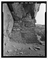
| 10 | Hovenweep National Monument |
 |
(#66000250) |
Northwest of Cortez 37°26′35″N 108°58′56″W / 37.443056°N 108.982222°W |
Cortez | |
| 11 | Indian Camp Ranch Archeological District |
(#12000145) |
Address Restricted |
Cortez vicinity | ||
| 12 | Joe Ben Wheat Site Complex |
(#03001383) |
Address Restricted |
Yellow Jacket | ||
| 13 | James A. Lancaster Site |
(#80000914) |
Address Restricted |
Pleasant View | ||
| 14 | Lebanon School |
(#96000543) |
24925 County Road T 37°27′28″N 108°35′29″W / 37.457778°N 108.591389°W |
Dolores | ||
| 15 | Lost Canyon Archeological District |
(#88001909) |
Address Restricted |
Mancos | ||
| 16 | Lowry Ruin |
 |
(#66000253) |
30 miles (48 km) northwest of Cortez via U.S. Route 160 Coordinates missing |
Pleasant View | |
| 17 | Mancos High School |
(#91001740) |
350 Grand Ave. 37°20′44″N 108°17′32″W / 37.345556°N 108.292222°W |
Mancos | ||
| 18 | Mancos Opera House |
 |
(#87002183) |
136 W. Grand Ave. 37°20′11″N 108°17′23″W / 37.336389°N 108.289722°W |
Mancos | |
| 19 | Mesa Verde Administrative District |
 |
(#87001410) |
Area at head of Spruce Canyon off park service road 37°10′59″N 108°29′26″W / 37.183056°N 108.490556°W |
Mesa Verde National Park | |
| 20 | Mesa Verde National Park |
 |
(#66000251) |
10 miles (16 km) east of Cortez on U.S. Route 160 37°14′52″N 108°27′06″W / 37.247821°N 108.451595°W |
Cortez | |
| 21 | Mitchell Springs Archeological Site |
(#01001207) |
7755 Road 25 37°19′30″N 108°35′44″W / 37.324893°N 108.595553°W |
Cortez | ||
| 22 | Montezuma Valley Irrigation Company Flume No. 6 |
 |
(#12000146) |
Approximately 4 miles (6.4 km) east of Cortez on US 160 Coordinates missing |
Cortez vicinity | |
| 23 | Montezuma Valley National Bank and Store Building |
 |
(#08001317) |
2-8 Main St. 37°20′55″N 108°35′06″W / 37.34864°N 108.58502°W |
Cortez | |
| 24 | Mud Springs Pueblo |
(#82001020) |
Address Restricted |
Cortez | ||
| 25 | Painted Hand Pueblo |
(#13000576) |
Address Restricted |
Pleasant View | ||
| 26 | Pigge Site |
(#80000915) |
Address Restricted |
Pleasant View | ||
| 27 | Roy's Ruin |
(#91002027) |
Address Restricted |
Cortez | ||
| 28 | Sand Canyon Archaeological District |
 |
(#05000138) |
Address Restricted |
Cortez | |
| 29 | Seven Towers Pueblo |
(#99000653) |
Address Restricted |
Yellow Jacket | ||
| 30 | Southern Hotel |
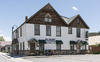 |
(#89000018) |
101 S. 5th St. 37°28′35″N 108°30′09″W / 37.476389°N 108.5025°W |
Dolores | |
| 31 | Ute Mountain Ute Mancos Canyon Historic District |
 |
(#72000273) |
Address Restricted |
Durango | |
| 32 | Woods Canyon Pueblo |
(#99000652) |
Address Restricted |
Yellow Jacket | ||
| 33 | Wrightsman House |
(#97000045) |
209 Bauer Ave. 37°20′45″N 108°17′25″W / 37.345833°N 108.290278°W |
Mancos | ||
| 34 | Yellowjacket Pueblo (5-MT-5) |
(#85002701) |
Address Restricted |
Yellow Jacket | ||
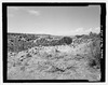
| 35 | Yucca House National Monument |
 |
(#66000252) |
12 miles (19 km) south of Cortez via U.S. Route 666 37°15′00″N 108°41′07″W / 37.25°N 108.685278°W |
Cortez |

All content from Kiddle encyclopedia articles (including the article images and facts) can be freely used under Attribution-ShareAlike license, unless stated otherwise. Cite this article:
National Register of Historic Places listings in Montezuma County, Colorado Facts for Kids. Kiddle Encyclopedia.