National Register of Historic Places listings in Moody County, South Dakota facts for kids
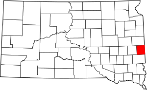
This is a list of the National Register of Historic Places listings in Moody County, South Dakota.
This is intended to be a complete list of the properties on the National Register of Historic Places in Moody County, South Dakota, United States. The locations of National Register properties for which the latitude and longitude coordinates are included below, may be seen in a map.
There are 16 properties listed on the National Register in the county. Another 3 properties were once listed but have been removed.
Current listings
| Name on the Register | Image | Date listed | Location | City or town | Description | |
|---|---|---|---|---|---|---|
| 1 | Crystal Theatre |
(#00001214) |
215 E. 2nd Ave. 44°02′57″N 96°35′32″W / 44.049167°N 96.592222°W |
Flandreau | ||
| 2 | Frank and Sarah Drake Claim House |
(#14001184) |
23982 466th Ave. Coordinates missing |
Chester vicinity | ||
| 3 | Egan Park |
(#03000556) |
2nd St. 43°59′58″N 96°38′18″W / 43.999444°N 96.638333°W |
Egan | ||
| 4 | George Few House |
(#83003017) |
208 1st Ave., E. 44°03′03″N 96°35′32″W / 44.050833°N 96.592222°W |
Flandreau | ||
| 5 | First Scandinavian Baptist Church |
(#00000999) |
2.5 miles south of Trent 43°52′15″N 96°38′41″W / 43.870833°N 96.644722°W |
Trent | ||
| 6 | Flandreau Masonic Temple |
(#89001725) |
300 E. 2nd Ave. 44°02′59″N 96°35′27″W / 44.049722°N 96.590833°W |
Flandreau | ||
| 7 | Japanese Gardens Dance Pavilion |
(#94001390) |
City park 44°03′29″N 96°34′15″W / 44.058056°N 96.570833°W |
Flandreau | ||
| 8 | Little Village Farm Sale Barn |
(#95001469) |
Off U.S. Route 77 northeast of Dell Rapids 43°54′24″N 96°41′18″W / 43.906667°N 96.688333°W |
Dell Rapids | ||
| 9 | Moody County Courthouse |
(#92001863) |
Pipestone Ave. between Crescent and Wind Sts. 44°02′53″N 96°35′38″W / 44.048056°N 96.593889°W |
Flandreau | ||
| 10 | Pettigrew Barns |
(#04000473) |
309 E. Broad 44°02′41″N 96°35′26″W / 44.044722°N 96.590556°W |
Flandreau | ||
| 11 | St. Mary's Episcopal Church |
(#01000998) |
North Crescent St. 44°03′29″N 96°35′38″W / 44.058056°N 96.593889°W |
Flandreau | ||
| 12 | St. Vincent's Hotel |
(#83003018) |
100 N. Wind 44°02′55″N 96°35′44″W / 44.048611°N 96.595556°W |
Flandreau | ||
| 13 | South Dakota Department of Transportation Bridge No. 51-051-000 |
(#99001699) |
Local road over the Big Sioux River 44°11′44″N 96°47′04″W / 44.195556°N 96.784444°W |
Lake Campbell Resort | Lost between 2007 and 2009 | |
| 14 | South Dakota Department of Transportation Bridge No. 51-102-010 |
(#99001693) |
Local road over Local Creek 44°10′54″N 96°41′18″W / 44.181667°N 96.688333°W |
Riverview Township | ||
| 15 | South Dakota Dept. of Trans. Br. No. 51-124-136 |
(#01000090) |
2nd St. over the Big Sioux River 43°59′54″N 96°38′19″W / 43.998333°N 96.638611°W |
Egan |
Former listings
| Name on the Register | Image | Date listed | Date removed | Location | City or town | Summary | |
|---|---|---|---|---|---|---|---|
| 1 | Sioux River Bridge |
(#99001696) |
|
3rd Street over Big Sioux River |
Trent | ||
| 2 | South Dakota Dept. of Trans. Br. No. 51-140-078 |
(#99001698) |
|
Local Road over Big Sioux River |
Flandreau | ||
| 3 | Ward Hall |
(#01001223) |
|
Main Street 44°09′17″N 96°27′35″W / 44.1547°N 96.4597°W |
Ward |

All content from Kiddle encyclopedia articles (including the article images and facts) can be freely used under Attribution-ShareAlike license, unless stated otherwise. Cite this article:
National Register of Historic Places listings in Moody County, South Dakota Facts for Kids. Kiddle Encyclopedia.

