
National Register of Historic Places listings in Ocean County, New Jersey facts for kids

List of the National Register of Historic Places listings in Ocean County, New Jersey
| Atlantic - Bergen - Burlington - Camden - Cape May - Cumberland - Essex - Gloucester - Hudson - Hunterdon - Mercer - Middlesex - Monmouth - Morris - Ocean - Passaic - Salem - Somerset - Sussex - Union - Warren |
This is intended to be a complete list of properties and districts listed on the National Register of Historic Places in Ocean County, New Jersey. The locations of National Register properties and districts (at least for all showing latitude and longitude coordinates below) may be seen in an online map by clicking on "Map of all coordinates".
| Name on the Register | Image | Date listed | Location | City or town | Description | |
|---|---|---|---|---|---|---|
| 1 | Barnegat Light Public School |
 |
(#76001178) |
501 Central Ave. 39°45′35″N 74°06′20″W / 39.759722°N 74.105556°W |
Barnegat Light | |
| 2 | Barnegat Lighthouse |
 |
(#71000512) |
North end of Long Beach Island, off Broadway Ave. 39°45′51″N 74°06′23″W / 39.764167°N 74.106389°W |
Barnegat Light | |
| 3 | Bartlett-Rockhill-Bartlett House |
 |
(#11001041) |
Bartlett Ln. 39°36′04″N 74°20′35″W / 39.601164°N 74.343167°W |
Tuckerton | |
| 4 | Bay Head Historic District |
.JPG) |
(#05001566) |
Roughly bounded by Point Pleasant Beach Borough line, Atlantic Ocean, Mantoloking Borough line and Point Pleasant 40°04′18″N 74°02′51″W / 40.071667°N 74.0475°W |
Bay Head | |
| 5 | Beach Haven Historic District |
 |
(#83001608) |
Roughly bounded by Bay and Atlantic Avenues, Pearl and 3rd Streets; later roughly bounded by Atlantic, Bay, 5th and Chatsworth 39°33′32″N 74°14′31″W / 39.558889°N 74.241944°W |
Beach Haven | Second set of addresses represents a boundary increase November 19, 2014. Also includes Converse Cottage and Dr. Edward H. Williams House |
| 6 | Capt. Amos Birdsall House |
 |
(#82003298) |
234 Washington St. 39°57′08″N 74°11′30″W / 39.952222°N 74.191667°W |
Toms River | |
| 7 | A.A. Brant House |
 |
(#82003294) |
9 Allen St. 39°57′04″N 74°11′43″W / 39.951111°N 74.195278°W |
Toms River | |
| 8 | Cassville Crossroads Historic District |
.JPG) |
(#82003291) |
Junction of CR 571 and CR 528 40°06′17″N 74°23′14″W / 40.104722°N 74.387222°W |
Jackson Township | |
| 9 | Cavalry Cottage |
 |
(#06000871) |
100 Stafford Ave. 39°41′50″N 74°15′19″W / 39.697222°N 74.255278°W |
Stafford Township | |
| 10 | Cedar Bridge Tavern |
 |
(#13000586) |
200 Old Halfway Rd. 39°47′00″N 74°21′38″W / 39.783333°N 74.360556°W |
Barnegat Township | |
| 11 | Converse Cottage |
 |
(#83001609) |
500 South Atlantic Avenue 39°33′32″N 74°14′23″W / 39.55875°N 74.239722°W |
Beach Haven | Part of Beach Haven MRA |
| 12 | Mary Etta Cox House |
 |
(#05000124) |
353 N. Main St. 39°45′13″N 74°13′26″W / 39.753611°N 74.223889°W |
Barnegat | |
| 13 | Crawford House |
 |
(#82003295) |
46 E. Water St. 39°57′03″N 74°11′46″W / 39.950833°N 74.196111°W |
Toms River | |
| 14 | Double Trouble Historic District |
 |
(#78001787) |
S of Beachwood off Garden State Pkwy. 39°53′51″N 74°13′37″W / 39.8975°N 74.226944°W |
Bayville | |
| 15 | Falkinburg Farmstead |
 |
(#93000829) |
28 Westcott Ave., Ocean Township 39°47′03″N 74°11′35″W / 39.784167°N 74.193056°W |
Waretown | |
| 16 | Elizabeth Sculthorp Force House |
 |
(#100003403) |
26 Hadley Ave. 39°57′10″N 74°11′27″W / 39.9529°N 74.1907°W |
Toms River Township | |
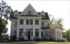
| 17 | Georgian Court |
 |
(#78001788) |
Lakewood Avenue 40°05′52″N 74°13′37″W / 40.097778°N 74.226944°W |
Lakewood | Also known as George Jay Gould Estate |
| 18 | Capt. George W. Giberson House |
 |
(#82004693) |
54 E. Water St. 39°57′03″N 74°11′46″W / 39.950833°N 74.196111°W |
Toms River | |
| 19 | Hangar No. 1, Lakehurst Naval Air Station |
 |
(#68000031) |
N of Lakehurst on CR 547 40°01′44″N 74°18′59″W / 40.028889°N 74.316389°W |
Manchester Township | |
| 20 | Horner House |
 |
(#82003296) |
44 E. Water St. 39°57′04″N 74°11′47″W / 39.9511°N 74.1964°W |
Toms River | |
| 21 | L. Ron Hubbard Residence at Bay Head |
 |
(#100001777) |
44 666 East Ave. 40°03′50″N 74°02′40″W / 40.0640°N 74.0444°W |
Bay Head | |
| 22 | Island Heights Historic District |
 |
(#82003290) |
Roughly bounded by Toms River, Summit and River Avenues 39°56′26″N 74°08′43″W / 39.9406°N 74.1453°W |
Island Heights | |
| 23 | Little Egg Harbor Friends Meeting House |
 |
(#02001511) |
21 E. Main St. 39°36′12″N 74°20′29″W / 39.6033°N 74.3414°W |
Tuckerton | |
| 24 | Manahawkin Baptist Church |
 |
(#73001131) |
N. Main St. (US 9) and Lehigh Ave. 39°41′55″N 74°15′29″W / 39.6986°N 74.2581°W |
Manahawkin | |
| 25 | Manitou Park School House |
 |
(#05000177) |
167 Third Ave. 39°56′48″N 74°13′03″W / 39.9467°N 74.2175°W |
Berkeley | |
| 26 | Ocean County Courthouse |
 |
(#83001610) |
Washington St. 39°57′10″N 74°11′41″W / 39.9528°N 74.1947°W |
Toms River | |
| 27 | Ocean County Jail |
 |
(#83001611) |
Sheriff St. 39°57′12″N 74°11′41″W / 39.9533°N 74.1947°W |
Toms River | |
| 28 | Old Coast Guard Station Manasquan Inlet |
 |
(#100006508) |
40 Inlet Dr. 40°06′09″N 74°02′16″W / 40.1026°N 74.0378°W |
Point Pleasant Beach | |
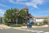
| 29 | Orient Baptist Church |
.JPG) |
(#77000902) |
NJ 88 40°04′11″N 74°07′40″W / 40.0697°N 74.1278°W |
Laurelton | |
| 30 | Stewart House |
 |
(#82003297) |
57 E. Water St. 39°57′03″N 74°11′46″W / 39.9508°N 74.1961°W |
Toms River | |
| 31 | Stoutenburgh-Minturn House |
 |
(#82003293) |
86 E. Water St. 39°57′02″N 74°11′36″W / 39.9506°N 74.1933°W |
Toms River | |
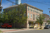
| 32 | Strand Theatre |
 |
(#82003292) |
400 Clifton Ave. 40°05′39″N 74°12′57″W / 40.0942°N 74.2158°W |
Lakewood | |
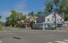
| 33 | Torrey-Larrabee Store |
 |
(#97000104) |
11 Union Ave. 40°06′09″N 74°18′34″W / 40.1025°N 74.3094°W |
Lakehurst | |
| 34 | U.S. Life Saving Station Station No. 14 |
 |
(#78001789) |
S of Seaside Park on Island Beach State Park 39°56′01″N 74°04′17″W / 39.9336°N 74.0714°W |
Seaside Park | |
| 35 | Whitesbog Historic District |
 |
(#88002115) |
N of SR 70 and S of Fort Dix 39°57′36″N 74°29′23″W / 39.96°N 74.4897°W |
Whiting | Extends into Burlington County |
| 36 | Dr. Edward H. Williams House |
 |
(#83001612) |
506 South Atlantic Avenue 39°33′30″N 74°14′24″W / 39.5583°N 74.2400°W |
Beach Haven | Part of Beach Haven MRA |
Current listings
| Name on the Register | Image | Date listed | Location | City or town | Description | |
|---|---|---|---|---|---|---|
| 1 | Barnegat Light Public School |
|
(#76001178) |
501 Central Ave. 39°45′35″N 74°06′20″W / 39.759722°N 74.105556°W |
Barnegat Light | |
| 2 | Barnegat Lighthouse |
|
(#71000512) |
North end of Long Beach Island, off Broadway Ave. 39°45′51″N 74°06′23″W / 39.764167°N 74.106389°W |
Barnegat Light | |
| 3 | Bartlett-Rockhill-Bartlett House |
(#11001041) |
Bartlett Ln. 39°36′04″N 74°20′35″W / 39.601164°N 74.343167°W |
Tuckerton | ||
| 4 | Bay Head Historic District |
|
(#05001566) |
Roughly bounded by Point Pleasant Beach Borough line, Atlantic Ocean, Mantoloking Borough line and Point Pleasant 40°04′18″N 74°02′51″W / 40.071667°N 74.0475°W |
Bay Head Borough | |
| 5 | Beach Haven Historic District |
|
(#83001608) |
Roughly bounded by Bay and Atlantic Aves., Pearl and 3rd Sts.; later roughly bounded by Atlantic, Bay, 5th & Chatsworth 39°33′32″N 74°14′31″W / 39.558889°N 74.241944°W |
Beach Haven | Second set of addresses represents a boundary increase 11/19/14. |
| 6 | Capt. Amos Birdsall House |
|
(#82003298) |
234 Washington St. 39°57′08″N 74°11′30″W / 39.952222°N 74.191667°W |
Toms River | |
| 7 | A.A. Brant House |
|
(#82003294) |
9 Allen St. 39°57′04″N 74°11′43″W / 39.951111°N 74.195278°W |
Toms River | |
| 8 | Cassville Crossroads Historic District |
 |
(#82003291) |
Jct. of CR 571 and 528 40°06′17″N 74°23′14″W / 40.104722°N 74.387222°W |
Jackson Township | |
| 9 | Cavalry Cottage |
|
(#06000871) |
100 Stafford Ave. 39°41′50″N 74°15′19″W / 39.697222°N 74.255278°W |
Stafford Township | |
| 10 | Cedar Bridge Tavern |
|
(#13000586) |
200 Old Halfway Rd. 39°47′00″N 74°21′38″W / 39.783333°N 74.360556°W |
Barnegat Township | |
| 11 | Converse Cottage |
|
(#83001609) |
504 Atlantic Ave. 39°33′31″N 74°14′25″W / 39.558611°N 74.240278°W |
Beach Haven | |
| 12 | Mary Etta Cox House |
|
(#05000124) |
353 N. Main St. 39°45′13″N 74°13′26″W / 39.753611°N 74.223889°W |
Barnegat | |
| 13 | Crawford House |
|
(#82003295) |
46 E. Water St. 39°57′03″N 74°11′46″W / 39.950833°N 74.196111°W |
Toms River | |
| 14 | Double Trouble Historic District |
|
(#78001787) |
S of Beachwood off Garden State Pkwy. 39°53′51″N 74°13′37″W / 39.8975°N 74.226944°W |
Bayville | |
| 15 | Falkinburg Farmstead |
|
(#93000829) |
28 Westcott Ave., Ocean Township 39°47′03″N 74°11′35″W / 39.784167°N 74.193056°W |
Waretown | |
| 16 | Georgian Court |
 |
(#78001788) |
Lakewood Ave. 40°05′52″N 74°13′37″W / 40.097778°N 74.226944°W |
Lakewood | |
| 17 | Capt. George W. Giberson House |
|
(#82004693) |
54 E. Water St. 39°57′03″N 74°11′46″W / 39.950833°N 74.196111°W |
Toms River | |
| 18 | Hangar No. 1, Lakehurst Naval Air Station |
|
(#68000031) |
N of Lakehurst on CR 547 40°01′44″N 74°18′59″W / 40.028889°N 74.316389°W |
Manchester Township | |
| 19 | Horner House |
|
(#82003296) |
44 E. Water St. 39°57′04″N 74°11′47″W / 39.951111°N 74.196389°W |
Toms River | |
| 20 | Island Heights Historic District |
 |
(#82003290) |
Roughly bounded by Toms River, Summit and River Aves. 39°56′26″N 74°08′43″W / 39.940556°N 74.145278°W |
Island Heights | |
| 21 | Little Egg Harbor Friends Meeting House |
|
(#02001511) |
21 E. Main St. 39°36′12″N 74°20′29″W / 39.603333°N 74.341389°W |
Tuckerton | |
| 22 | Manahawkin Baptist Church |
|
(#73001131) |
N. Main St. (US 9) and Lehigh Ave. 39°41′55″N 74°15′29″W / 39.698611°N 74.258056°W |
Manahawkin | |
| 23 | Manitou Park School House |
|
(#05000177) |
167 Third Ave. 39°56′48″N 74°13′03″W / 39.946667°N 74.2175°W |
Berkeley | |
| 24 | Ocean County Courthouse |
|
(#83001610) |
Washington St. 39°57′10″N 74°11′41″W / 39.952778°N 74.194722°W |
Toms River | |
| 25 | Ocean County Jail |
|
(#83001611) |
Sheriff St. 39°57′12″N 74°11′41″W / 39.953333°N 74.194722°W |
Toms River | |
| 26 | Orient Baptist Church |
|
(#77000902) |
NJ 88 40°04′11″N 74°07′40″W / 40.069722°N 74.127778°W |
Laurelton | |
| 27 | Stewart House |
|
(#82003297) |
57 E. Water St. 39°57′03″N 74°11′46″W / 39.950833°N 74.196111°W |
Toms River | |
| 28 | Stoutenburgh-Minturn House |
|
(#82003293) |
86 E. Water St. 39°57′02″N 74°11′36″W / 39.950556°N 74.193333°W |
Toms River | |
| 29 | Strand Theatre |
|
(#82003292) |
400 Clifton Ave. 40°05′39″N 74°12′57″W / 40.094167°N 74.215833°W |
Lakewood | |
| 30 | Torrey-Larrabee Store |
|
(#97000104) |
11 Union Ave. 40°06′09″N 74°18′34″W / 40.1025°N 74.309444°W |
Lakehurst | |
| 31 | U.S. Life Saving Station Station No. 14 |
|
(#78001789) |
S of Seaside Park on Island Beach State Park 39°56′01″N 74°04′17″W / 39.933611°N 74.071389°W |
Seaside Park | |
| 32 | Whitesbog Historic District |
|
(#88002115) |
N of SR 70 and S of Fort Dix 39°57′36″N 74°29′23″W / 39.96°N 74.489722°W |
Whiting | |
| 33 | Dr. Edward H. Williams House |
|
(#83001612) |
506 S. Atlantic Ave. 39°33′31″N 74°14′25″W / 39.558611°N 74.240278°W |
Beach Haven |

All content from Kiddle encyclopedia articles (including the article images and facts) can be freely used under Attribution-ShareAlike license, unless stated otherwise. Cite this article:
National Register of Historic Places listings in Ocean County, New Jersey Facts for Kids. Kiddle Encyclopedia.