National Register of Historic Places listings in Saguache County, Colorado facts for kids
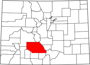
This is a list of the National Register of Historic Places listings in Saguache County, Colorado.
This is intended to be a complete list of the properties and districts on the National Register of Historic Places in Saguache County, Colorado, United States. The locations of National Register properties and districts for which the latitude and longitude coordinates are included below, may be seen in a map.
There are 9 properties and districts listed on the National Register in the county.
| Adams - Alamosa - Arapahoe - Archuleta - Baca - Bent - Boulder - Broomfield - Chaffee - Cheyenne - Clear Creek - Conejos - Costilla - Crowley - Custer - Delta - Denver - Dolores - Douglas - Eagle - El Paso - Elbert - Fremont - Garfield - Gilpin - Grand - Gunnison - Hinsdale - Huerfano - Jackson - Jefferson - Kiowa - Kit Carson - La Plata - Lake - Larimer - Las Animas - Lincoln - Logan - Mesa - Mineral - Moffat - Montezuma - Montrose - Morgan - Otero - Ouray - Park - Phillips - Pitkin - Prowers - Pueblo - Rio Blanco - Rio Grande - Routt - Saguache - San Juan - San Miguel - Sedgwick - Summit - Teller - Washington - Weld - Yuma |
Current listings
| Name on the Register | Image | Date listed | Location | City or town | Description | |
|---|---|---|---|---|---|---|
| 1 | Capilla de San Juan Bautista |
(#80000926) |
Northwest of La Garita 37°51′01″N 106°15′46″W / 37.850278°N 106.262778°W |
La Garita | ||
| 2 | Carnero Creek Pictographs |
(#75000540) |
Address Restricted |
La Garita | ||
| 3 | Crestone School |
(#86000011) |
Cottonwood St. and Carbonate Ave. 37°59′48″N 105°41′57″W / 37.996667°N 105.699167°W |
Crestone | ||
| 4 | First Baptist Church of Moffat |
(#08000710) |
401 Lincoln Ave. 37°59′54″N 105°54′20″W / 37.998342°N 105.905543°W |
Moffat | Ornamental Concrete Block Buildings in Colorado Multiple Property Submission | |
| 5 | Indian Grove |
(#00000237) |
Address Restricted |
Mosca | ||
| 6 | Saguache Downtown Historic District |
(#14000433) |
Roughly 300 & 400 blks. of 4th St. 38°05′14″N 106°08′13″W / 38.0871°N 106.1369°W |
Saguache | ||
| 7 | Saguache Flour Mill |
(#78000885) |
West of Saguache 38°04′53″N 106°09′38″W / 38.081389°N 106.160556°W |
Saguache | ||
| 8 | Saguache School and Jail Buildings |
(#75000541) |
U.S. Highway 285 and San Juan Ave. 38°05′16″N 106°08′38″W / 38.087778°N 106.143889°W |
Saguache | ||
| 9 | Sargents Water Tank, Denver and Rio Grande Railroad, Western Line |
(#10000537) |
45 Front St. 38°24′16″N 106°24′57″W / 38.404444°N 106.415833°W |
Sargents | Railroads in Colorado, 1858-1948 MPS |

All content from Kiddle encyclopedia articles (including the article images and facts) can be freely used under Attribution-ShareAlike license, unless stated otherwise. Cite this article:
National Register of Historic Places listings in Saguache County, Colorado Facts for Kids. Kiddle Encyclopedia.


