
National Register of Historic Places listings in Washington County, North Carolina facts for kids

This list includes properties and districts listed on the National Register of Historic Places in Washington County, North Carolina. Click the "Map of all coordinates" link to the right to view a Google map of all properties and districts with latitude and longitude coordinates in the table below.
Current listings
| Name on the Register | Image | Date listed | Location | City or town | Description | |
|---|---|---|---|---|---|---|
| 1 | Belgrade and St. David's Church |
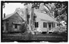 |
(#78001983) |
E of Creswell St. 35°52′21″N 76°22′54″W / 35.872578°N 76.381564°W |
Creswell | |
| 2 | Creswell Historic District |
 |
(#02001112) |
Roughly bounded by 208 E. Main St. and 310 W. Main St., 302-304 S. Sixth Sts., and 219 N. Sixth St. 35°52′11″N 76°23′38″W / 35.869656°N 76.393969°W |
Creswell | |
| 3 | Davenport House |
(#07000932) |
VA 1143 (Mount Tabor Rd. and VA 1146 (Mount Tabor Road-Backwoods 35°52′15″N 76°26′59″W / 35.870753°N 76.449725°W |
Creswell | ||
| 4 | Garrett's Island House |
(#01000047) |
1445 Garrett's Island Rd. 35°50′48″N 76°42′22″W / 35.846603°N 76.706236°W |
Plymouth | ||
| 5 | Latham House |
(#76001348) |
311 E. Main St. 35°52′01″N 76°44′46″W / 35.866944°N 76.746111°W |
Plymouth | ||
| 6 | Perry-Spruill House |
(#85000905) |
326 Washington St. 35°51′50″N 76°44′57″W / 35.863889°N 76.749167°W |
Plymouth | ||
| 7 | Plymouth Historic District |
(#90002140) |
Roughly bounded by Monroe St., the Roanoke R., Latham La., Third St., Washington St. and the Norfolk Southern RR tracks 35°51′51″N 76°45′00″W / 35.864167°N 76.75°W |
Plymouth | ||
| 8 | Rehoboth Methodist Church |
(#76001349) |
E of Skinnersville on U.S. 64 35°56′22″N 76°31′23″W / 35.939444°N 76.523056°W |
Skinnersville | ||
| 9 | Somerset Place State Historic Site |
 |
(#70000481) |
In Pettigrew State Park 35°47′15″N 76°24′20″W / 35.7875°N 76.405556°W |
Creswell | |
| 10 | Washington County Courthouse |
(#79001761) |
Main and Adams Sts. 35°52′00″N 76°44′57″W / 35.866667°N 76.749167°W |
Plymouth |

All content from Kiddle encyclopedia articles (including the article images and facts) can be freely used under Attribution-ShareAlike license, unless stated otherwise. Cite this article:
National Register of Historic Places listings in Washington County, North Carolina Facts for Kids. Kiddle Encyclopedia.