
Navarre, Florida facts for kids
Quick facts for kids
Navarre, Florida
|
|
|---|---|

Navarre Beach Skyline
|
|
| Nickname(s):
Florida's Most Relaxing Place
Florida's Best Kept Secret Florida's Playground The South's Quiet Crossroad |
|

|
|

Navarre, Florida
Location in Florida

Navarre, Florida
Location in the United States
|
|
| Country | United States |
| State | Florida |
| County | Santa Rosa |
| First explored | 1693 |
| Settled | 1850 |
| Founded | 1925 |
| Founded by | Guy Wyman |
| Named for | Province in Spain, Navarre |
| Government | |
| • Body | Santa Rosa County |
| Area | |
| • Census-designated place | 29.33 sq mi (75.96 km2) |
| • Land | 23.07 sq mi (59.75 km2) |
| • Water | 6.27 sq mi (16.24 km2) |
| Elevation | 10 ft (3 m) |
| Lowest elevation | 0 ft (0 m) |
| Population
(2020)
|
|
| • Census-designated place | 41,930 |
| • Density | 950.89/sq mi (367.14/km2) |
| • Metro | 461,227 (Pensacola metropolitan area) |
| Demonym(s) | Navarreian, Navarrite |
| Time zone | UTC−6 (CST) |
| • Summer (DST) | UTC−5 (CDT) |
| ZIP Code |
32566
|
| Area code(s) | 850/448 |
| FIPS code | 12-48050 |
| Waterways | See List of waterways in Navarre, Florida |
| Website | www.getrelaxing.com |
| Known circa 1693 as "Robledal" Known from 1884-1895 as "Eagen" and "Bilowry" Known circa 1921 as "Hiawatha" |
|
| Historical population | |||
|---|---|---|---|
| Census | Pop. | %± | |
| 1970 | 1,500 | — | |
| 1990 | 8,673 | — | |
| 2000 | 19,255 | 122.0% | |
| 2010 | 31,378 | 63.0% | |
| 2020 | 41,940 | 33.7% | |
| Includes both Navarre and Navarre Beach CDP |
|||
Navarre is a census-designated place and unincorporated community in Santa Rosa County in the northwest Florida Panhandle. It is a major bedroom community for mostly U.S. military personnel, federal civil servants, local population, retirees and defense contractors. Due to Navarre Beach and the 4 miles (6.4 km) of beach front on the Gulf of Mexico thereof, as well as several miles of beaches within the Navarre Beach Marine Park and the Gulf Islands National Seashore, it has a small, but rapidly growing community of nature enthusiasts and tourists. Navarre has grown from being a small town of around 1,500 in 1970 to a town with a population estimated at 41,940 as of 2020[update], if including both the Navarre and Navarre Beach Census Designated Places.
Navarre is about 25 miles (40 km) east of Pensacola and about 15 miles (24 km) west of Fort Walton Beach. The community is roughly centered on the junction of U.S. Route 98 and State Road 87. It is part of the Pensacola–Ferry Pass–Brent Metropolitan Statistical Area (more commonly referred to as the Pensacola Metro Area), and is the second largest community in the metropolitan area, according to a 2014 study. Navarre is the third-largest community in the Florida Panhandle.
Navarre is also part of the Fort Walton Beach-Navarre-Wright Urbanized Area. It is known for the natural environment, swimming, picnic spots, and its beach.
Contents
History
The Pez-Sigüenza Expedition of 1693
In 1693, Spanish explorers Carlos de Sigüenza y Góngora and Admiral Andrés de Pez y Malzarraga, set sail from Veracruz, Mexico. A skilled cartographer, scientist, mathematician and theologian, Sigüenza was responsible for scouting and mapping possible sites of Spanish colonization in Northwest Florida during the expedition. While traveling in the area of East Bay in April 1693, the Spanish discovered what is today called the East Bay River. In honor of Captain Jordan de Reina, an officer who had taken part in the Barroto-Romero voyage of 1686 as well as Sigüenza's in 1693, the Spanish dubbed the waters on which they traveled, "The River Jordan". On April 11, 1693, while sailing up East Bay River, sailors aboard the Spanish ships noticed a group of Native Americans observing them from a camp near the shore. In order to greet the natives, a landing party was sent out. By the time the Spanish reached the shore however, the Native Americans were gone. At the natives quickly abandoned camp, the Spanish discovered half-cooked pieces of buffalo meat sitting over a fire, along with a fierce dog guarding the site. Due to the great number of oak trees in that place, the campsite was called “El Robledal”, meaning "The Oakgrove" in Spanish. After erecting a wooden cross and leaving gifts for the natives, the Spaniards continued their exploration upriver. Upon later return to El Robledal, the explorers noticed that their gifts had been taken. In return, the natives had also constructed a wooden cross and left a buffalo hide as a peace offering. The earliest-known map of Robledal dates from 1693, the same year as the Pez-Sigüenza Expedition. Three years later, in a 1698 map by Don Andrés de Arriola y Guzmán (the first governor of a settlement in the Pensacola area after the Tristán de Luna y Arellano colony was abandoned), Robledal is again noted.
Town of Eagan
Approximately 41 years before Guy H. Wyman platted Navarre, a small settlement named Eagan arose in 1884. The settlement, composed of 40 families, was located off the Santa Rosa Sound and encompassed a portion of present-day Navarre. The settlement, which formerly existed as a post office location, was named after its first postmaster, John Eagan Esq., a famous Pensacola lawyer and politician. Following the post office’s discontinuation on September 11, 1884, families continued to live in the area, and the town continued to appear on area maps even into the 1890s. While what became of the town and the people who lived there at that time is unknown, the discovery of the town's existence definitively established settlement of the Navarre area in South Santa Rosa County as being prior to the 20th century. The land upon which Eagan existed would, in fact, later become what is now known as Navarre.
Guy Wyman and town development
The founder of Navarre was Guy Wyman, a colonel in the United States Army. During World War I, he met a French nurse named Noelle. At the time, immigration policies would not allow him to bring her to the United States as a fiancée or even as a wife, but he could bring her back as his legal child. Col. Wyman therefore adopted her, and brought her back to the Florida panhandle, where he purchased a large amount of land. Noelle named their holdings Navarre, after the province in Spain, near France. Wyman platted the town in 1925, but made no steps towards development. However, during the Great Depression, the Wymans could not pay the taxes on it, and were forced to begin selling it off. Part of that property is where the Navarre Park is today. While protecting and enhancing the natural beauty of the area; several steps have been taken to develop luxury accommodations, water activities, boutique shopping, scenic trails, top rated schools and nature/educational opportunities.
Helicopter crash
On March 10, 2015, a UH-60 from Eglin Air Force Base crashed in the Santa Rosa Sound off the coast of the community of Navarre. All eleven on board were believed killed. On November 18, 2016 Leadership Santa Rosa Class 29 unveiled the Navarre Black Hawk Memorial in Navarre Park. The memorial was built to honor the men who died in the Black Hawk crash and anyone who has paid the ultimate sacrifice in service to the United States.
Geography
Navarre is located at 30°24′04″N 86°51′47″W / 30.401°N 86.863°W. It is located within a portion of the Florida Panhandle observing the Central Time Zone. Elevation is 10 feet.
Navarre is on roughly 12 miles of shoreline.
The community of Navarre is located on the Gulf Coastal Plain and is built on mostly sandy soil. Navarre is located on the Fairpoint Peninsula. It is bunded geographically in the north by the East River and on the south by the Santa Rosa Sound.
Demographics
Navarre is a large community, estimated to have 41,940 people in the community, according to several different estimates completed since 2014. If the town of Navarre was to be incorporated it would be the largest city between Pensacola and Tallahassee (based on population). This is a major increase from just 40 years ago, when the population was hovering around 1,500. The below racial characteristics of the community are from 2017 estimates.
- Non-Hispanic White 75.6%
- African-American 9.0%
- Hispanic 9.6%
- Multiracial 5.2%
- Asian 3.0%
- Native Hawaiian and other Pacific Islander 0.2%
- Native American and Alaska Native 0.2%
Attractions


Navarre is centered near the junction of U.S. Highway 98, the primary east-west route between Pensacola and the Fort Walton Beach area, and State Road 87. It is located near several large military facilities: Naval Air Station Pensacola to the west; Hurlburt Field and Eglin Air Force Base to the east; and Naval Air Station Whiting Field to the North.
Tourism has increased in the Navarre area since 2010, being declared "Florida's Best Kept Secret" by the local hospitality business. Navarre has a park on the mainland next to Navarre Beach bridge and the Intracoastal Waterway that contains a Visitor Information Center; water splash pad, duck pond, butterfly house, playground, gazebos; pier and small beach area. Boating, Surfing, jet skiing, paddle boarding, fishing, bird watching, exploring scenic trails and walking/jogging are popular among the residents and visitors. Navarre's fourth hotel, the first beachfront hotel to operate since 2004, a Springhill Suites will be completed and opened sometime in early 2017.
In 2010 the Navarre Beach fishing pier was rebuilt after repeated damage from hurricanes. At 1,545-feet, it is currently the longest fishing pier on the Gulf of Mexico and in the state of Florida.
Hurricanes
As a low-elevation community near the Gulf of Mexico, Navarre is often threatened by hurricanes. Significant damage was incurred as a result of Hurricanes Erin, Opal, Ivan and Dennis. Many homes and businesses immediately along Santa Rosa Sound (generally south of U.S. Highway 98) suffered storm surge as a result of those storms. Recoveries have been rendered by the area with the population quickly flourishing. This area of Florida is consistently listed as one of the worst places for hurricanes.
Popular Culture
Jaws 2

A large portion of the scenes in Jaws 2 were filmed off the coast of Navarre and Navarre Beach circa 1977. The production "was a boost to the local economy because local boaters, extras and stand-ins or doubles were hired. Universal brought in actors, directors, producers and their wives, camera and crew people who needed housing, food and clothing for the movie. Services were needed for laundry, dry-cleaning and recreation." Navarre's Holiday Inn "Holidome" was used as the film's headquarters, with the ground floor converted into production offices, and some of the Gulf-front suites remodelled for David Brown and Roy Scheider. Universal rented 100 of the hotel's 200 rooms, spending $1 million. The Holiday Inn was destroyed in the 2004 Atlantic hurricane season. A new Springhill Suites is being built on the same site as the Holiday Inn and will be completed sometime during March 2017.
Infrastructure
Education and library
Education in Navarre is administrated by the Santa Rosa County District School system headquartered in Milton, Florida. The schools that serve the Navarre community are:
- Navarre High School (Grades 9–12)
- Holley-Navarre Middle School (Grades 6–8)
- Holley-Navarre Intermediate School (Grades 3–5)
- Holley-Navarre Primary School (Grades K–2)
- Woodlawn Beach Middle School (Grades 6–8)
- West Navarre Primary School (Grades K–2)
- West Navarre Intermediate School (Grades 3–5)
- East Bay K-8 School (Opened 2021; Grades K-8)
Public library services are provided by the Santa Rosa County Library System through the Navarre Library.
Parks and recreation
| Navarre Park | |
|---|---|
| Type | County Park |
| Location | Navarre, Florida |
| Area | 7 Acres |
| Operated by | Santa Rosa County Department of Parks and Recreation |
| Visitors | ~100,000 annually |
| Open | Partially, under renovation |
The community of Navarre has several public parks open year-round. These parks are currently owned and operated by the Santa Rosa County Department of Parks and Recreation and are open to the public. The Navarre Sports Complex and Navarre Soccer Complex, while owned and largely managed by the county, are partially operated by the Navarre Youth Sports Association.
The largest of the parks are the Navarre Beach Marine Park, Navarre Park (which is currently under renovation), and the Navarre Sports Complex.
Navarre Park provides a play area for children, basketball courts, picnic pavilions, and restroom facilities. The park hosts several large community events each year. In October 2020, Phase 1 of park renovations began. Enhancements to the park include an interactive splash pad, ADA accessible restroom facilities, playgrounds for two age groups, a plaza with shade structures, maintenance building, park building, expanded parking, landscaping and stormwater improvements. Phase 1 is scheduled to be finished by the summer of 2021. Phase 2 and 3 renovations include demolishing the pavers, wood decks, footbridge and pilings, new stormwater improvements, constructing walkways, lighting, and a seawall, addition of a Remembrance Plaza with protective cover, demolishing existing parking surfaces, picnic shelters and pavilions, constructing new parking areas, picnic areas, shelters, pavilions, lighting and landscaping. Phase 2 and 3 will be up for bid after phase 1 is completed.
Transportation
Transportation infrastructure in Navarre is relatively limited and is dominated by roads, instead of public transportation or sidewalks. This has been to the chagrin of some local citizens. However, relatively little has been done to improve this within the last few years, beyond feasibility studies of possible improvements.
Roadways
Navarre is centered on the intersection of U.S. Highway 98 (named "Navarre Parkway" while within the town) and Florida State Road 87 (which has no official name, though is sometimes called "the Navarre Beach Expressway" by local residents). These provide the two largest connections in and out of the town. The Parkway (US 98) connects west to Pensacola, ultimately ending in Mississippi, and connects east to Destin and Fort Walton Beach, ultimately ending in Lakeland, Florida. The Expressway has its southern terminus in Navarre; however, it connects north to Interstate 10 and Milton, then ending at the Alabama state border.
Navarre also has secondary connections through Florida State Road 399 and Santa Rosa County Road 399. Because of their matching shield numbers, the two are often confused by residents and tourists alike and are often instead referred to as "Gulf Boulevard" and "East Bay Boulevard" respectively. Gulf Boulevard, which has its northern terminus in Navarre, travels on Santa Rosa Island, ultimately going through the Opal Beach section of the Gulf Islands National Seashore, Pensacola Beach, then ending in Gulf Breeze. East Bay Boulevard, which has its eastern terminus in Navarre, travels roughly parallel to East Bay and the East Bay River. It also passes by Gable Lake and passes over the Tom King Bayou, before connecting with US 98 in the neighboring community of Woodlawn Beach, Florida.
Due to traffic flow issues on both the primary and secondary thoroughfares, a community access road has been proposed by citizens and county leaders alike. An inquiry into the feasibility of such a plan is being conducted by county officials.
Airports
Navarre doesn't have a dedicated commercially served airport. Instead, it is largely served by Pensacola International Airport (about 25 miles west in Pensacola) and Destin–Fort Walton Beach Airport (about 30 miles east in Valparaiso, Florida).
Navarre does have one general aviation airfield, confusingly named Fort Walton Beach Airport, despite being both located and registered within Navarre, not the nearby city of Fort Walton Beach, Florida. The airfield has a single turf runway and primarily serves banner-towing aerial advertising aircraft, that fly ads along the beach.
Navarre did also host an outlying airfield of Naval Air Station Whiting Field, Naval Outlying Landing Field Holley; however, this airfield has since been converted into operations as one of the largest solar fields in the region. Currently being operated by Gulf Power, in cooperation with the United States Navy.
Public transportation
Navarre has limited public transportation, despite some public calls for it. However, it is does receive service from Santa Rosa Transportation, which provides some on-demand accessibility service from the town.
Notable people
Entertainment
- Logan Bauer, finalist on the 29th Season of the Amazing Race
- Anne Rice, gothic fiction writer
Sports
- Michael Carter, running back for the New York Jets
- Matt Cronin, relief pitcher for the Washington Nationals
- Jordan Leggett, former tight end for the Tampa Bay Buccaneers
- Michael "Crash" Lockwood, WWE wrestler
- Akeem Spence, free agent defensive tackle
- Jeff Van Camp, former quarterback for the Florida Atlantic Owls
Images for kids
-
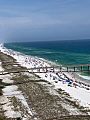
A busy day on Navarre Beach
-
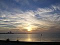
Santa Rosa Sound as viewed from the Navarre Beach Causeway


See also
 In Spanish: Navarre (Florida) para niños
