
Needles, California facts for kids
Quick facts for kids
Needles, California
|
|
|---|---|
| City of Needles | |
_(cropped).jpg) .jpg) .jpg) .JPG) Top: Needles Theatre (left), Old Trails Bridge (center), town sign (right); bottom: El Garcés.
|
|

Location in San Bernardino County and the state of California
|
|
| Country | United States |
| State | California |
| County | San Bernardino County |
| Incorporated | October 30, 1913 |
| Area | |
| • Total | 31.08 sq mi (80.49 km2) |
| • Land | 30.58 sq mi (79.20 km2) |
| • Water | 0.50 sq mi (1.29 km2) 1.49% |
| Elevation | 495 ft (151 m) |
| Population
(2020)
|
|
| • Total | 4,931 |
| • Density | 162.73/sq mi (62.83/km2) |
| Time zone | UTC−8 (Pacific) |
| • Summer (DST) | UTC−7 (PDT) |
| ZIP Code |
92363
|
| Area codes | 442/760 |
| FIPS code | 06-50734 |
| GNIS feature IDs | 1652757, 2411220 |
Needles is a city in San Bernardino County, California, in the Mojave Desert region of Southern California. Situated on the western banks of the Colorado River, Needles is located near the Californian border with Arizona and Nevada. The city is accessible via Interstate 40 and U.S. Route 95. The population was 4,844 at the 2010 census, up from 4,830 at the 2000 census.
Contents
History
"Ancient petroglyphs, pictographs, intaglios art, and old trails and stonework sites, bear witness to those who came from an earlier time."
The Mohave, one of the traditional Colorado River Indian Tribes, are Native Americans that have been living in the Mojave Valley area for thousands of years prior to the European exploration of the area. In the Mohave language, they call themselves the ʼAha Makhav. Their name comes from two words: ʼaha, meaning 'river', and makhav, meaning 'along or beside', and to them it means 'people who live along the river'.
The historic Mojave Road now goes through the Mojave National Preserve. Along it, in 1859, Fort Mojave was built to protect new pioneer immigrants to California and other travelers from the Mohave.
The city was founded in May 1883 as a result of the construction of the Atchison, Topeka and Santa Fe Railway which originally crossed the Colorado River at this point. The name was derived from the Needles, pointed mountain peaks where the wind-blown holes in them (which can only be seen by boat from the Colorado River), at the south end of the valley. This point on the Colorado River was a poor site for such a bridge, lacking firm banks and a solid bottom. Additionally, the bridge was not of the best quality, which led to criticism that it was a "flimsy looking structure", and was an obstruction to navigation since it lacked a draw to allow boat traffic. The flooding and meandering of the Colorado River destroyed the bridge in 1884, 1886 and 1888. Finally the railroad surrendered to nature and built a high cantilever bridge at a much narrower point with solid rock footings, ten miles downstream near modern Topock, completing it in May 1890.
Originally a tent town for railroad construction crews, the railroad company built a hotel, car sheds, shops and a roundhouse. Within a month the town also boasted a Chinese washhouse, a newsstand, a restaurant, a couple of general stores, and nine or ten saloons. The town became the largest port on the river above Yuma, Arizona. The Railway and the Fred Harvey Company built the elegant Neoclassical and Beaux-Arts style El Garces Hotel and Santa Fe Station in 1908 which was considered the "Crown Jewel" of the entire Fred Harvey chain. The landmark building is on the National Register of Historic Places and is being restored.
Needles was a major stop on the historic U.S. Route 66 highway from the 1920s through the 1960s. For immigrants from the Midwest Dust Bowl in the 1930s it was the first town that marked their arrival in California. The city is lined with motels and other shops from that era. The "Carty's Camp" which appears briefly in The Grapes of Wrath as the Joad family enters California from Arizona is now a ghost tourist court, its remains located behind the 1946-era 66 Motel.
In 1949 the US Bureau of Reclamation began a mass project to dredge a new channel for the Colorado River that would straighten out a river bend that was causing massive silt problems since the Hoover Dam was completed.
Needles is a tourism and recreation center, a tradition going back for decades. The city is the eastern gateway to the Mojave National Preserve, a scenic desert National Park.
Climate
Needles, like Death Valley to the northwest, is known for extreme heat during the summer. The city has a subtropical desert climate. Temperatures often reach 120 °F (49 °C) in late July and early August. The Needles weather station is frequently reported by the United States government's National Oceanic and Atmospheric Administration (NOAA) as the site of the highest daily temperature recorded in the U.S. during the desert summers. Needles occasionally sets national or world daily temperature records.
The mean annual temperature for Needles, CA is 74.2 °F (23.4 °C).
In the winter, the normal high temperatures range from 62 °F (17 °C) to 80 °F (27 °C) with lows of 40 °F (4 °C) to 60 °F (16 °C). During summer the normal high temperatures range from 106 °F (41 °C) to 122 °F (50 °C) with lows of 82 °F (28 °C) to 94 °F (34 °C). Annual rainfall is about 5.11 inches (130 mm).
On July 22, 2006, Needles experienced a record high low temperature, with a temperature recorded to be 100 °F (38 °C) at 6:00 AM with a high temperature exceeding 120 °F (49 °C).
On August 13, 2012, Needles experienced a thunderstorm that deposited rain at a temperature of 115 °F (46 °C) starting at 3:56 PM, setting a new record for the hottest rain in world history. The air temperature was 118 °F (48 °C), tying Needles' record high for the date. Since the humidity was only 11%, the rain evaporated so that "only a trace of precipitation was recorded in the rain gauge". Weather records researcher Maximiliano Herrera reported that this was the lowest humidity at which rain has occurred on Earth in recorded history.
The record low temperature was 20 °F on December 23, 1990. The average year has 168.4 days with highs of 90 °F (32 °C) or higher and 4.9 days with lows of 32 °F (0 °C) or lower.
There are normally 23 days with measurable precipitation. The wettest year was 1965 with 9.50 inches and the driest year was 2006 with 0.70 inches. The most rainfall in one month was 4.72 inches in September 1976. The most rainfall in 24 hours was 2.55 inches on August 28, 1951. Although snowfall is very rare in Needles, 15.2 inches of snow fell in January 1949, including 12.2 inches on January 12, 1949.
The city is also known for moderate to locally severe thunderstorms during the monsoon season as well as humid conditions.
Needles is served by the National Weather Service's NOAA Weather Radio operating on 162.50 MHz from the Las Vegas National Weather Service.
On Monday, June 20, 2016, Needles recorded a high temperature of 125 °F (51.7 °C); this ties the all time temperature record, recorded on July 17, 2005, and breaks the previous June record of 123 °F (50.6 °C) recorded on June 29, 2013.
| Climate data for Needles, California | |||||||||||||
|---|---|---|---|---|---|---|---|---|---|---|---|---|---|
| Month | Jan | Feb | Mar | Apr | May | Jun | Jul | Aug | Sep | Oct | Nov | Dec | Year |
| Record high °F (°C) | 85 (29) |
92 (33) |
99 (37) |
107 (42) |
115 (46) |
125 (52) |
125 (52) |
121 (49) |
120 (49) |
109 (43) |
92 (33) |
83 (28) |
125 (52) |
| Average high °F (°C) | 65.0 (18.3) |
69.8 (21.0) |
77.2 (25.1) |
85.2 (29.6) |
95.0 (35.0) |
104.2 (40.1) |
108.8 (42.7) |
106.9 (41.6) |
100.4 (38.0) |
87.5 (30.8) |
73.4 (23.0) |
63.3 (17.4) |
86.5 (30.3) |
| Average low °F (°C) | 43.5 (6.4) |
46.7 (8.2) |
51.5 (10.8) |
58.6 (14.8) |
68.3 (20.2) |
77.2 (25.1) |
84.3 (29.1) |
82.8 (28.2) |
74.5 (23.6) |
62.0 (16.7) |
50.3 (10.2) |
42.5 (5.8) |
61.9 (16.6) |
| Record low °F (°C) | 21 (−6) |
24 (−4) |
30 (−1) |
39 (4) |
44 (7) |
53 (12) |
57 (14) |
62 (17) |
52 (11) |
34 (1) |
30 (−1) |
20 (−7) |
20 (−7) |
| Average precipitation inches (mm) | 0.72 (18) |
0.78 (20) |
0.54 (14) |
0.22 (5.6) |
0.09 (2.3) |
0.03 (0.76) |
0.16 (4.1) |
0.48 (12) |
0.43 (11) |
0.26 (6.6) |
0.40 (10) |
0.51 (13) |
4.62 (117) |
| Source: http://www.wrcc.dri.edu/cgi-bin/cliMAIN.pl?ca6118 | |||||||||||||
Demographics
| Historical population | |||
|---|---|---|---|
| Census | Pop. | %± | |
| 1920 | 2,807 | — | |
| 1930 | 3,144 | 12.0% | |
| 1940 | 3,624 | 15.3% | |
| 1950 | 4,051 | 11.8% | |
| 1960 | 4,590 | 13.3% | |
| 1970 | 4,051 | −11.7% | |
| 1980 | 4,120 | 1.7% | |
| 1990 | 5,191 | 26.0% | |
| 2000 | 4,830 | −7.0% | |
| 2010 | 4,844 | 0.3% | |
| 2019 (est.) | 4,976 | 2.7% | |
| U.S. Decennial Census | |||
2000

As of the census of 2000, there were 4,830 people, 1,940 households, and 1,268 families residing in the city. The estimated population in July 2006: 5,330 (+10.4% change). The population density was 162.3 per square mile (62.6/km2). There were 2,551 housing units at an average density of 85.7 per square mile (33.1/km2). The racial makeup of the city was 77.9% White, 1.6% African American, 7.0% Native American, 1.4% Asian, 0.1% Pacific Islander, 6.4% from other races, and 5.6% from two or more races. Hispanic or Latino of any race were 18.4% of the population.
There were 1,940 households, out of which 31.2% had children under the age of 18 living with them, 42.5% were married couples living together, 16.8% had a female householder with no husband present, and 34.6% were non-families. 29.0% of all households were made up of individuals, and 13.1% had someone living alone who was 65 years of age or older. The average household size was 2.5 and the average family size was 3.0.
In the city, the population was spread out, with 27.6% under the age of 18, 7.5% from 18 to 24, 23.6% from 25 to 44, 25.6% from 45 to 64, and 15.7% who were 65 years of age or older. The median age was 39 years. For every 100 females, there were 96.7 males. For every 100 females age 18 and over, there were 92.2 males.
The median income for a household in the city was $26,108, and the median income for a family was $33,264. Males had a median income of $39,688 versus $19,483 for females. The per capita income for the city was $15,156. About 21.2% of families and 26.1% of the population were below the poverty line, including 38.2% of those under age 18 and 11.3% of those age 65 or over.
Major employment in the city is supported by the BNSF Railway (formerly the Santa Fe Railroad). The depot has been a terminal (crew change point) for the railway since the late 19th century. The railroad company has been the city's main employment source for over a century.
According to the United States Census Bureau, the city has a total area of 30.2 square miles (78 km2). 29.8 square miles (77 km2) of it is land and 0.4 square miles (1.0 km2) of it (1.36%) is water.
The once smaller nearby communities of Bullhead City, Arizona, Lake Havasu City, Arizona, and Laughlin, Nevada have in recent years become larger communities than Needles.
2010
.jpg)
The 2010 United States Census reported that Needles had a population of 4,844. The population density was 154.9 people per square mile (59.8/km2). The racial makeup of Needles was 3,669 (75.7%) White (65.4% Non-Hispanic White), 95 (2.0%) African American, 399 (8.2%) Native American, 35 (0.7%) Asian, 9 (0.2%) Pacific Islander, 323 (6.7%) from other races, and 314 (6.5%) from two or more races. Hispanic or Latino of any race were 1,083 persons (22.4%).
The Census reported that 4,839 people (99.9% of the population) lived in households, 5 (0.1%) lived in non-institutionalized group quarters, and 0 (0%) were institutionalized.
There were 1,918 households, out of which 650 (33.9%) had children under the age of 18 living in them, 712 (37.1%) were opposite-sex married couples living together, 331 (17.3%) had a female householder with no husband present, 159 (8.3%) had a male householder with no wife present. There were 186 (9.7%) unmarried opposite-sex partnerships, and 6 (0.3%) same-sex married couples or partnerships. 588 households (30.7%) were made up of individuals, and 238 (12.4%) had someone living alone who was 65 years of age or older. The average household size was 2.52. There were 1,202 families (62.7% of all households); the average family size was 3.12.
The population was spread out, with 1,283 people (26.5%) under the age of 18, 401 people (8.3%) aged 18 to 24, 1,038 people (21.4%) aged 25 to 44, 1,357 people (28.0%) aged 45 to 64, and 765 people (15.8%) who were 65 years of age or older. The median age was 39.3 years. For every 100 females, there were 101.6 males. For every 100 females age 18 and over, there were 95.0 males.
There were 2,895 housing units at an average density of 92.6 per square mile (35.7/km2), of which 1,015 (52.9%) were owner-occupied, and 903 (47.1%) were occupied by renters. The homeowner vacancy rate was 4.9%; the rental vacancy rate was 17.2%. 2,578 people (53.2% of the population) lived in owner-occupied housing units and 2,261 people (46.7%) lived in rental housing units.
According to the 2010 United States Census, Needles had a median household income of $29,613, with 28.8% of the population living below the poverty line.
Popular culture
Movies
Movies using locations in Needles:
- The Grapes of Wrath (1940)
- Two-Lane Blacktop (1971)
- Convoy (1978)
- Repo Man (1984)
- Evicted (2000)
- Domino (2005)
- Criminal Xing (2007)
- Into the Wild (2007)
In the 1993 film Suture, the town of Needles is a key element of the plot.
Books
- In John Steinbeck's novel The Grapes of Wrath, the Joad family stops in Needles when they enter California on Route 66.
Print media
- In the comic strip Peanuts, whose creator Charles Schulz lived in Needles as a boy, Snoopy's brother Spike lived in the desert outside Needles. He frequently heads to Needles to partake of the town's nightlife, often running afoul of the local coyotes.
Recordings
- In 2004, John Lowery (John 5), former guitarist for Marilyn Manson, released his CD Vertigo, in which the first track is entitled "Needles CA."
- The town is mentioned in the lyrics of Hoyt Axton's "Never Been To Spain"; the song was a hit for Three Dog Night in 1972 and was also performed by Elvis –
Well I never been to England, but I kinda like the Beatles. Well, I headed for Las Vegas, only made it out to Needles. Can you feel it? Must be real. It feels so good!
- Izzy Stradlin's 1999 album Ride On includes a track entitled "Needles" about his love of visiting the town.
- In 2009 the song "Don't Look Down" by Barnaby Bright included the following :
We pulled into a truck stop Somewhere just outside of Needles California, You asked me for ten bucks and I said “What about the last ten bucks I loaned you?”
Television
- In October 2006, two students and two teachers from Needles High School were invited to Washington DC to meet with the Under Secretary of Defense, in which they spoke of the new program at Needles High School called MOCK National Security Workshop. The students were also interviewed for the nationwide, fifteen-minute television news show, Channel One News, where the episode was aired on October 25.
- Needles was the main site of a 2009 UFO Hunters episode investigating a supposed UFO Crash.
- Needles High School was on a School Pride television episode November 12, 2010.
- In the Sex and the City season 6 episode "Out of the Frying Pan", Smith Jerrod and Samantha Jones attend the movie premiere of a Gus Van Sant film called Needles, CA’'.
- Route 66 (1960) "The Strengthening Angels" TV Episode
- The Amazing Race (2001) TV Series
Other connections
- April 10, 1992: 38-year-old comedian Sam Kinison was killed in a head-on car crash outside of Needles. His newlywed wife was critically injured.

- In late 2000 to early 2001, skateboard legend Tony Hawk donated $10,000 to the Needles Skate Park, which is still in use today. Hawk was present for the grand opening of the park in January 2004.
- Needles (and the surrounding area) was the scene for the hit 1988 post-apocalyptic computer RPG Wasteland.
- Murals paying homage to U.S. 66, the celebrated "Mother Road" which passed through Needles on its way between Chicago and Los Angeles, and painted by local artist Dan Louden, have become a popular tourist attraction.
Visits by famous people
- January 11, 1960: Former First Lady Eleanor Roosevelt spoke at a forum established by the Needles School District. The school district had established, as a part of their adult education program, a forum that brought in persons from many areas of thought and culture. She dined with Mr. and Mrs. Max Rafferty, Superintendent of the Needles School District. Her hosts during the visit were a Mr. and Mrs. Bender and their children.
Education
Needles' elementary schools and Needles High School are part of the Needles Unified School District. The school district is one of the largest in the United States in terms of area with almost 6,000 square miles (16,000 km2) in its boundaries. The district runs from Amboy to Needles, and south to Parker Dam. It has 1,158 students enrolled. The local Needles schools include Katie Hohstadt Elementary School, formerly called 'D' Street School (new home of Needles Head Start, and no longer a regular public school), Vista Colorado Elementary School (grades K–5), Needles Middle School (grades 6–8), Needles High School (grades 9–12), and the Educational Training Center (grades 9–12). Needles High School, due to its distance from other California schools, is a member of the Nevada Interscholastic Activities Association, along with four other similarly placed California schools: Truckee, North Tahoe, South Tahoe, and Coleville.
Needles also has two private schools: the Needles Assembly of God Christian School and the Needles Seventh-day Adventist School.
Infrastructure
.JPG)
Transportation
Interstate 40, known locally as the Needles Freeway, is the major highway through Needles, connecting Barstow to the west and Arizona to the east. U.S. Route 95 also enters the city from the east on former Route 66 as a concurrency with the I-40 freeway, then splits with the Interstate west of the city, and heads north to Nevada. The Colorado River Bridge connects Needles directly with Mohave County, Arizona, and Arizona State Route 95.
Amtrak, the national passenger rail system, provides daily service to Needles station, operating its Southwest Chief between Chicago and Los Angeles. It arrives between midnight and 2 am.
Local transit service to the Needles area is provided by Needles Area Transit.
As of August 2, 2016, Victor Valley Transit Authority has service from Needles to Barstow and Victorville on Fridays. To Barstow and Victorville, the bus leaves at 6:15 and arrives at Victorville at 10:30 am. On the reverse trip, buses leave Victorville at 2:30 pm and arrives at Barstow at 7:15 pm.
Vegas Airporter provides service between Lake Havasu City, Needles, and McCarran International Airport in Las Vegas.
Public safety
On July 1, 2016, San Bernardino County Fire Department annexed the City of Needles. Fire Station 32 provides fire protection to the City of Needles and houses two Type 1 Engine companies, one Type 7 Engine company, one Water Tender and one 28 foot fireboat. The station is staffed full-time with career firefighters.
Since December 1989 the City of Needles has been patrolled by the San Bernardino County Sheriff's Department under the command of Captain Ross Tarangle from the Needles Patrol Station.
Notable people
- Pat Morris, Mayor of San Bernardino, California.
- Max Rafferty, Needles Superintendent of Schools, 1955–1961, became California Superintendent of Public Instruction 1962–1970.
- Charles Schulz, cartoonist of Peanuts, lived in Needles 1928–30 and made it the residence of Snoopy's brother Spike.
- Bess Houdini, wife and stage assistant of famed escape artist Harry Houdini, died in Needles in 1943.
- Yara tav, leader of the Mohave people (1861–1874), born close to the Needles rock formation before the establishment of the town.
- Alice Notley, American poet, grew up in Needles.
- Natalie Diaz American poet and winner of the 2021 Pulitzer Prize for Poetry.
Images for kids
-
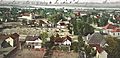
View of Needles in 1912.
-
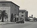
Downtown Needles, c. 1930's.
-
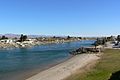
The Colorado River separates Needles, in California, from Mohave Valley, in Arizona.
.jpg)
_(cropped).jpg)

See also
 In Spanish: Needles (California) para niños
