Nerang, Queensland facts for kids
Quick facts for kids NerangGold Coast, Queensland |
|||||||||||||||
|---|---|---|---|---|---|---|---|---|---|---|---|---|---|---|---|

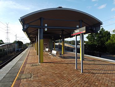
Nerang railway station
|
|||||||||||||||
| Population | 16,864 (2016 census) | ||||||||||||||
| • Density | 469.7/km2 (1,217/sq mi) | ||||||||||||||
| Postcode(s) | 4211 | ||||||||||||||
| Area | 35.9 km2 (13.9 sq mi) | ||||||||||||||
| Time zone | AEST (UTC+10:00) | ||||||||||||||
| Location |
|
||||||||||||||
| LGA(s) | Gold Coast City | ||||||||||||||
| State electorate(s) | Gaven | ||||||||||||||
| Federal Division(s) | |||||||||||||||
|
|||||||||||||||
Nerang is a town and suburb in the City of Gold Coast, Queensland, Australia. In the 2016 census, Nerang had a population of 16,864 people.
History
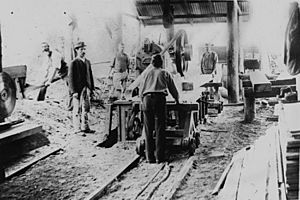
A town survey was conducted in 1865. Nerang has focused very much on the river crossing and the head of navigation. Land was first sold here in 1871. Daily Cobb & Co coach services from Brisbane began the same year and river transport to the settlement became more regular. With an abundant supply of red cedar amongst other tree species, the first industry to flourish in the area was timber cutting. In 1875, Nerang State School opened.
Sugar and maize were grown by farmers along the upper reaches of the river. The arrival of the railway in 1887 gave added impetus to the town. In 1927, a timber building was the first built specifically for use as the Council Chambers. During World War II the Australian Army's 4th Armoured Brigade operated a tank training centre at Nerang.
The Shire of Nerang became part of the Shire of Albert in 1950 and the Chambers became a post office. Recent years have seen the early Nerang flourish as an administrative centre for the growing Gold Coast.
Transport
The construction of the 'new' Pacific Highway on the old railway reserve has helped to focus development in the town in a manner which has extended and indeed largely swamped the early township. Its character is however still dependent upon the river and the early subdivision and commercial centre survives.
Nerang is a regional and transportation hub, containing several shopping centres and Nerang Station.
The South Coast railway opened in 1889 with a station at Nerang. The railway and the station closed in 1964. The Pacific Motorway follows the route of the original railway. The new Gold Coast railway line was opened progressively from 1996 with the current Nerang railway station on a different site.
Community
The Nerang Branch Library is located on the corner of White & Price Streets. The Nerang Branch Library also holds the Special Needs Library Collection which contains specialist materials for developmental and disability needs.
Sport and recreation
A number of well-known sporting teams represent the local area, including the Nerang Roosters is the local rugby league club and Nerang Bulls RUC are the local Rugby Union club who play home games at Robert Dalley Park. The Carrara Sports Ground is located a short distance away from the Nerang Train Station with Metricon Stadium being the home for of the Gold Coast Suns AFL football team. The area surrounding the Carrara Sports Ground has undertaken significant development in anticipation for the 2018 Commonwealth Games.
Nerang also boasts a velodrome and a public swimming pool complex that has 3 pools owned and operated by the Gold Coast City Council. The Mudgeeraba/Nerang Cricket Club also has its home ground at Carrara with turf wicket, practice nets and club house facilities. It has teams in all grades from juniors through to first grade in the Gold Coast District Cricket competition. There are also a number of world class golf courses within easy reach from Nerang. The Nerang Division takes in areas such as Springbrook, Natural Arch, the Rock Pools and Lower Beechmont; all great places to take the family for picnics, horse riding and bush walking.
Education
Nerang State School is a government primary (Prep-6) school for boys and girls at 3 Nerang Street (27°59′19″S 153°20′18″E / 27.9886°S 153.3384°E). In 2018, the school had an enrolment of 325 students with 28 teachers (23 full-time equivalent) and 21 non-teaching staff (12 full-time equivalent). It includes a special education program.
St Brigid's Catholic Primary School is a Catholic primary (Prep-6) school for boys and girls at 39-49 McLaren Road (28°00′03″S 153°19′06″E / 28.0008°S 153.3183°E). In 2018, the school had an enrolment of 406 students with 31 teachers (25 full-time equivalent) and 17 non-teaching staff (10 full-time equivalent).
Nerang State High School is a government secondary (7-12) school for boys and girls at Weedons Road (28°00′02″S 153°19′40″E / 28.0005°S 153.3278°E). In 2018, the school had an enrolment of 1026 students with 93 teachers (88 full-time equivalent) and 43 non-teaching staff (31 full-time equivalent). It includes a special education program.
Notable residents
- Sara Carrigan - Athens 2004 Olympic gold medalist in road bicycle racing
- Billy Drumley, Indigenous community leader
- Sydney Barber Josiah Skertchly (1850 – 1926), botanist and geologist, buried in the cemetery.


