
Nevada, Iowa facts for kids
Quick facts for kids
Nevada, Iowa
|
|
|---|---|
 |
|

Location of Nevada, Iowa
|
|
| Country | |
| State | |
| County | Story |
| Area | |
| • Total | 5.78 sq mi (14.97 km2) |
| • Land | 5.77 sq mi (14.94 km2) |
| • Water | 0.01 sq mi (0.03 km2) |
| Elevation | 1,001 ft (305 m) |
| Population
(2020)
|
|
| • Total | 6,925 |
| • Density | 1,200.17/sq mi (463.41/km2) |
| Time zone | UTC-6 (Central (CST)) |
| • Summer (DST) | UTC-5 (CDT) |
| ZIP code |
50201
|
| Area code(s) | 515 |
| FIPS code | 19-55695 |
| GNIS feature ID | 0459461 |
Nevada ( nə-VAY-də) is a city in, and the county seat of, Story County, Iowa, United States. The population was 6,925 in the 2020 census, an increase from 6,658 in 2000. Nevada is part of the Ames, Iowa Metropolitan Statistical Area, which is a part of the larger Ames-Boone, Iowa Combined Statistical Area. Nevada is the second-most populous city in Story County, Iowa. The city's name is pronounced differently from the U.S. state of Nevada.
Contents
History

Nevada was platted in 1853. It was named after the Sierra Nevada mountains. A post office has been in operation in Nevada since 1854.
Geography
Nevada's longitude and latitude coordinates in decimal form are 42.019152, -93.451775.
According to the United States Census Bureau, the city has a total area of 5.08 square miles (13.16 km2), of which, 5.06 square miles (13.11 km2) is land and 0.02 square miles (0.05 km2) is water.
Demographics
| Historical population | |||
|---|---|---|---|
| Census | Pop. | %± | |
| 1860 | 350 | — | |
| 1870 | 982 | 180.6% | |
| 1880 | 1,541 | 56.9% | |
| 1890 | 1,662 | 7.9% | |
| 1900 | 2,472 | 48.7% | |
| 1910 | 2,138 | −13.5% | |
| 1920 | 2,668 | 24.8% | |
| 1930 | 3,133 | 17.4% | |
| 1940 | 3,353 | 7.0% | |
| 1950 | 3,763 | 12.2% | |
| 1960 | 4,227 | 12.3% | |
| 1970 | 4,952 | 17.2% | |
| 1980 | 5,912 | 19.4% | |
| 1990 | 6,009 | 1.6% | |
| 2000 | 6,658 | 10.8% | |
| 2010 | 6,798 | 2.1% | |
| 2020 | 6,925 | 1.9% | |
| U.S. Decennial Census | |||
2010 census
As of the census of 2010, there were 6,798 people, 2,761 households, and 1,811 families residing in the city. The population density was 1,343.5 inhabitants per square mile (518.7/km2). There were 2,990 housing units at an average density of 590.9 per square mile (228.1/km2). The racial makeup of the city was 94.3% White, 1.3% African American, 0.3% Native American, 1.0% Asian, 1.7% from other races, and 1.5% from two or more races. Hispanic or Latino of any race were 3.4% of the population.
There were 2,761 households, of which 34.0% had children under the age of 18 living with them, 51.3% were married couples living together, 10.6% had a female householder with no husband present, 3.7% had a male householder with no wife present, and 34.4% were non-families. 29.6% of all households were made up of individuals, and 10.5% had someone living alone who was 65 years of age or older. The average household size was 2.38 and the average family size was 2.94.
The median age in the city was 37.1 years. 25.3% of residents were under the age of 18; 7.6% were between the ages of 18 and 24; 27.1% were from 25 to 44; 26.1% were from 45 to 64; and 14% were 65 years of age or older. The gender makeup of the city was 48.6% male and 51.4% female.
Transportation
Nevada is served by US Highway 30 which was known as the Lincoln Highway and Lincoln Way in town. It bisects Nevada north and south through the business district. A new US Highway 30 bypass was built in the 1970s to the south of the city and Lincoln Way through town was reduced to county road status. Iowa Highway 133 now connects the business district to the new US Highway 30 to the south. Nevada is also served well by a network of paved farm to market county roads.
Nevada was served by the Chicago and North Western Railroad. The Union Pacific Railroad now owns the line which crosses the city east to west north of the business district. Up until the mid-1980s, all railroad crossings except for a new one in the northwest section of town were protected by WRRS center harp style wigwag signals. Shortly thereafter, these signals were replaced with standard flashers and gates due to safety concerns and lack of available wigwag parts.
Nevada was also served by the Chicago, Rock Island and Pacific Railroad's "Spine Line" between Minneapolis, MN and Kansas City, MO. This north-south line jogged east-west through southern Nevada. It then veered north again and crossed under the C&NW mainline east of Nevada. An agency station was maintained until 1980 when the Rock Island went bankrupt and ceased to function.
The C&NW purchased the Rock Island "Spine Line" which offered better and more direct connections for Minneapolis and Kansas City. Since the two rail lines did not directly interchange east of town where the C&NW crosses over the Rock Island, a new connection on the west side of Nevada was built. It goes from the C&NW east-west main line to connect with the former Rock Island on the southwest side of Nevada. The junction on the Spine Line was referred to as "Chicago Junction" while the junction on the east-west mainline was referred to as "Kansas City Junction". This new line necessitated the building of an overpass for the old Lincoln Highway on the west side of Nevada.
The Union Pacific Railroad purchased the Chicago and North Western Railroad in 1995. Rail traffic on both the east-west mainline and the "Spine Line" along with interchange traffic has increased considerably in the years since the purchase.
Education
Nevada Community School District operates public schools. The school colors are purple and gold, and the mascot is a cub.
- Central Elementary School
- Nevada Community Middle School
- Nevada Community High School
- Nevada Community Resource Center
Notable people
- Dayton Countryman (1918–2011), Iowa Attorney General
- Neva Patterson (1920–2010), actress
- Paul Rhoads (born 1967) college football coach, former head coach at Iowa State University
- Billy Sunday, baseball player and evangelist
- Michael Wacha, baseball player for St. Louis Cardinals, grandson of a local family
Images for kids
-
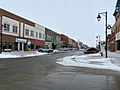
Downtown Nevada

See also
 In Spanish: Nevada (Iowa) para niños
