New Haven, Missouri facts for kids
Quick facts for kids
New Haven, Missouri
|
|
|---|---|
 |
|
| Nickname(s):
sun drop country
|
|

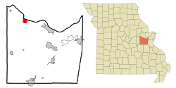
Location of New Haven, Missouri
|
|
| Country | United States |
| State | Missouri |
| County | Franklin |
| Area | |
| • Total | 3.38 sq mi (8.75 km2) |
| • Land | 3.21 sq mi (8.32 km2) |
| • Water | 0.16 sq mi (0.42 km2) |
| Elevation | 673 ft (205 m) |
| Population
(2010)
|
|
| • Total | 2,089 |
| • Estimate
(2019)
|
2,072 |
| • Density | 644.88/sq mi (249.01/km2) |
| Time zone | UTC-6 (Central (CST)) |
| • Summer (DST) | UTC-5 (CDT) |
| ZIP code |
63068
|
| Area code(s) | 573 |
| FIPS code | 29-51914 |
| GNIS feature ID | 0731625 |
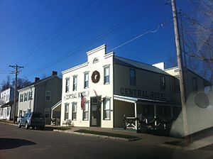
New Haven is a city in Franklin County, Missouri, United States. The population was 2,089 at the 2010 census.
New Haven is within the Hermann AVA (American Viticultural Area).
New Haven is home to Pinckney Bend Distillery, an international award-winning distillery founded in 2011 in the historic downtown.
Contents
History
New Haven was originally called Miller's Landing, and uner the latter name was platted in 1855. A post office called New Haven has been in operation since 1858. New Haven also claims to be the founding city of Sun Drop and has a Pepsi plant located in it. New Haven is also the home of Pinckney Bend Distillery which has won several international awards for its spirits.
The AME Church of New Haven, New Haven Commercial Historic District, New Haven Residential Historic District, Wilhelm Pelster House-Barn, and Christopher and Johanna Twelker Farm are listed on the National Register of Historic Places.
Geography
New Haven is located at 38°36′18″N 91°13′5″W / 38.60500°N 91.21806°W (38.604989, -91.218137).
According to the United States Census Bureau, the city has a total area of 3.45 square miles (8.94 km2), of which, 3.29 square miles (8.52 km2) is land and 0.16 square miles (0.41 km2) is water.
Demographics
| Historical population | |||
|---|---|---|---|
| Census | Pop. | %± | |
| 1880 | 471 | — | |
| 1890 | 767 | 62.8% | |
| 1900 | 883 | 15.1% | |
| 1910 | 855 | −3.2% | |
| 1920 | 805 | −5.8% | |
| 1930 | 876 | 8.8% | |
| 1940 | 1,002 | 14.4% | |
| 1950 | 1,009 | 0.7% | |
| 1960 | 1,223 | 21.2% | |
| 1970 | 1,474 | 20.5% | |
| 1980 | 1,581 | 7.3% | |
| 1990 | 1,757 | 11.1% | |
| 2000 | 1,867 | 6.3% | |
| 2010 | 2,089 | 11.9% | |
| 2019 (est.) | 2,072 | −0.8% | |
| U.S. Decennial Census | |||
2010 census
As of the census of 2010, there were 2,089 people, 818 households, and 533 families living in the city. The population density was 635.0 inhabitants per square mile (245.2/km2). There were 905 housing units at an average density of 275.1 per square mile (106.2/km2). The racial makeup of the city was 95.1% White, 0.7% African American, 0.6% Native American, 0.3% Asian, 1.7% from other races, and 1.6% from two or more races. Hispanic or Latino of any race were 2.1% of the population.
There were 818 households, of which 34.8% had children under the age of 18 living with them, 49.6% were married couples living together, 10.6% had a female householder with no husband present, 4.9% had a male householder with no wife present, and 34.8% were non-families. 30.9% of all households were made up of individuals, and 14% had someone living alone who was 65 years of age or older. The average household size was 2.45 and the average family size was 3.08.
The median age in the city was 36.5 years. 25.9% of residents were under the age of 18; 7.6% were between the ages of 18 and 24; 25.9% were from 25 to 44; 24% were from 45 to 64; and 16.7% were 65 years of age or older. The gender makeup of the city was 46.6% male and 53.4% female.
Education
New Haven School District operates one elementary school, one middle school and New Haven High School.
New Haven has a public library, a branch of the Scenic Regional Library system.
See also
 In Spanish: New Haven (Misuri) para niños

