New Madrid County, Missouri facts for kids
Quick facts for kids
New Madrid County
|
|
|---|---|

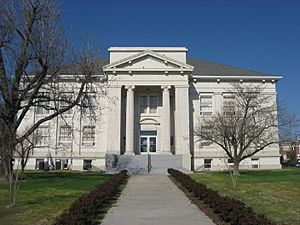
New Madrid County Courthouse
|
|

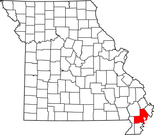
Location within the U.S. state of Missouri
|
|
 Missouri's location within the U.S. |
|
| Country | |
| State | |
| Founded | October 1, 1812 |
| Named for | Madrid, Spain |
| Seat | New Madrid |
| Largest city | New Madrid |
| Area | |
| • Total | 697 sq mi (1,810 km2) |
| • Land | 675 sq mi (1,750 km2) |
| • Water | 22 sq mi (60 km2) 3.1% |
| Population
(2020)
|
|
| • Total | 16,434 |
| • Density | 23.578/sq mi (9.104/km2) |
| Time zone | UTC−6 (Central) |
| • Summer (DST) | UTC−5 (CDT) |
| Congressional district | 8th |
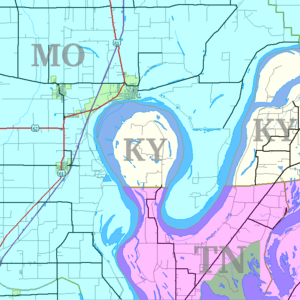
New Madrid County ( MAD-rid; Spanish: Condado de Nueva Madrid; French: Comté de New Madrid) is a county located in the Bootheel of the U.S. state of Missouri. As of the 2020 census, the population was 16,434.The largest city and county seat is New Madrid, located on the northern side of the Kentucky Bend in the Mississippi River, where it has formed an oxbow around an exclave of Fulton County, Kentucky. This feature has also been known as New Madrid Bend or Madrid Bend, for the city.
The county was officially organized on October 1, 1812, and is named after Nuevo Madrid, a district located in the region. This area was under Spanish rule following France's cession of Louisiana after being defeated in the Seven Years' War. The Spanish named the district after Madrid, the capital of Spain.
The county includes a large part of the New Madrid Fault that produced the 1811–12 New Madrid earthquakes. This zone remains geologically active, and had continued to produce smaller earthquakes with some frequency.
Contents
History
French Canadians from New France landed in this area in 1781 and established the first settlement in the present county at New Madrid along the Mississippi River. Later France ceded this area to Spain following its loss in the Seven Years' War. Spain returned it to France late in the 18th century, and France sold this and a large area west of the Mississippi River in 1803 to the United States under the Louisiana Purchase.
New Madrid County was organized on October 1, 1812, as an act of the First General Assembly of the Missouri Territory. In the floodplain of the Mississippi, this area was long cultivated for cotton production.
A series of more than 1,000 earthquakes struck the area in 1811 and 1812. The New Madrid earthquakes were the strongest non-subduction zone earthquake in the United States. A request dated January 13, 1814, by the Territorial Governor William Clark, asked for federal relief for the "inhabitants of New Madrid County."
The county had its peak of population in 1940, according to US census data, as shown in the table. Many residents left the county from 1950 to 1970, seeking better work opportunities. County population has continued to decline.
Geography
According to the U.S. Census Bureau, the county has a total area of 697 square miles (1,810 km2), of which 675 square miles (1,750 km2) is land and 22 square miles (57 km2) (3.1%) is water.
The county is located on the Kentucky Bend of the Mississippi River, which forms a border of the county. This feature is also known as New Madrid Bend or Madrid Bend. This oxbow flows around an exclave of Fulton County, Kentucky. Scientists expect that eventually the river will cut a new channel across the narrow neck of the peninsula, which will gradually be attached by infill land to Missouri.
Adjacent counties
- Scott County (north)
- Mississippi County (northeast)
- Fulton County, Kentucky (south and east across the Mississippi river)
- Lake County, Tennessee (south across the river)
- Pemiscot County (south)
- Dunklin County (southwest)
- Stoddard County (northwest)
Major highways
 Interstate 55
 U.S. Route 60
 U.S. Route 61
 U.S. Route 62
 Route 153
 Route 162
Demographics
| Historical population | |||
|---|---|---|---|
| Census | Pop. | %± | |
| 1820 | 2,296 | — | |
| 1830 | 2,350 | 2.4% | |
| 1840 | 4,554 | 93.8% | |
| 1850 | 5,541 | 21.7% | |
| 1860 | 5,654 | 2.0% | |
| 1870 | 6,357 | 12.4% | |
| 1880 | 7,694 | 21.0% | |
| 1890 | 9,317 | 21.1% | |
| 1900 | 11,280 | 21.1% | |
| 1910 | 19,488 | 72.8% | |
| 1920 | 25,180 | 29.2% | |
| 1930 | 30,262 | 20.2% | |
| 1940 | 39,787 | 31.5% | |
| 1950 | 39,444 | −0.9% | |
| 1960 | 31,350 | −20.5% | |
| 1970 | 23,420 | −25.3% | |
| 1980 | 22,945 | −2.0% | |
| 1990 | 20,928 | −8.8% | |
| 2000 | 19,760 | −5.6% | |
| 2010 | 18,956 | −4.1% | |
| 2020 | 16,434 | −13.3% | |
| U.S. Decennial Census 1790-1960 1900-1990 1990-2000 2010-2015 |
|||
As of the census of 2000, there were 19,760 people, 7,824 households, and 5,508 families residing in the county. The population density was 29 people per square mile (11/km2). There were 8,600 housing units at an average density of 13 per square mile (5/km2). The racial makeup of the county was 83.21% White, 15.36% Black or African American, 0.19% Native American, 0.14% Asian, 0.01% Pacific Islander, 0.32% from other races, and 0.78% from two or more races. Approximately 0.93% of the population were Hispanic or Latino of any race. Among the major first ancestries reported in New Madrid County were 32.4% American, 10.3% Irish, 8.8% English, and 8.7% German ancestry.
There were 7,824 households, out of which 32.80% had children under the age of 18 living with them, 52.00% were married couples living together, 14.60% had a female householder with no husband present, and 29.60% were non-families. 26.50% of all households were made up of individuals, and 13.20% had someone living alone who was 65 years of age or older. The average household size was 2.48 and the average family size was 2.99.
In the county, the population was spread out, with 26.40% under the age of 18, 8.50% from 18 to 24, 26.40% from 25 to 44, 23.20% from 45 to 64, and 15.50% who were 65 years of age or older. The median age was 37 years. For every 100 females there were 92.40 males. For every 100 females age 18 and over, there were 86.50 males.
The median income for a household in the county was $32,758, and the median income for a family was $39,411. Males had a median income of $28,408 versus $19,186 for females. The per capita income for the county was $17,227. About 18.60% of families and 22.10% of the population were below the poverty line, including 31.40% of those under age 18 and 19.20% of those age 65 or over.
Religion
According to the Association of Religion Data Archives County Membership Report (2000), New Madrid County is a part of the Bible Belt as evangelical Protestantism is the majority religion. The most predominant denominations among residents in New Madrid County who adhere to a religion are Southern Baptists (62.86%), Roman Catholics (8.80%), and Methodists (7.36%).
Communities
- Canalou
- Catron
- Conran
- Gideon
- Howardville
- Kewanee
- Lilbourn
- Marston
- Matthews
- Morehouse
- New Madrid (county seat)
- North Lilbourn
- Parma
- Point Pleasant
- Portageville
- Risco
- Sikeston
- Tallapoosa
Education
Of adults 25 years of age and older in New Madrid County, 63.6% possess a high school diploma or higher while 9.6% hold a bachelor's degree or higher as their highest educational attainment.
Public schools
- Gideon School District 37 - Gideon
- Gideon Elementary School (K-6)
- Gideon High School (7-12)
- New Madrid County Central R-I School District - New Madrid
- Lilbourn Elementary School (PK-5) - Lilbourn
- Matthews Elementary School (PK-5) - Matthews
- New Madrid County Central Elementary School (PK-5)
- New Madrid County Central Middle School (6-08)
- New Madrid County Central High School (9-12)
- Portageville School District - Portageville
- Portageville Elementary School (PK-5)
- Portageville Middle School (6-8)
- Portageville High School (9-12)
- Risco R-II School District - Risco
- Risco Elementary School (K-6)
- Risco High School (7-12)
Private schools
- St. Eustachius Elementary School - Portageville - (PK-8) - Roman Catholic
- Immaculate Conception School - New Madrid - (PK-8) - Roman Catholic
Alternative/vocational schools
- New Madrid Bend Youth Center - New Madrid - (6-12) - Alternative
- New Madrid R-I Technical Skills Center - New Madrid - (9-12) - Vocational/Technical
Public libraries
- Lilbourn Memorial Library
- New Madrid County Library
See also
 In Spanish: Condado de Nueva Madrid para niños


