
New Providence facts for kids

An artistic rendition of the Battle of Nassau
|
|

New Providence (Bahamas)
|
|
| Geography | |
|---|---|
| Location | Atlantic Ocean |
| Coordinates | 25°02′N 77°24′W / 25.033°N 77.400°W |
| Archipelago | The Bahamas |
| Area | 207 km2 (80 sq mi) |
| Length | 34 km (21.1 mi) |
| Width | 11 km (6.8 mi) |
| Highest elevation | 5 m (16 ft) |
| Administration | |
|
|
|
| Demographics | |
| Population | 248,948 |
| Pop. density | 1,594 /km2 (4,128 /sq mi) |
New Providence is the most populous island in The Bahamas, containing more than 70% of the total population.
The island was originally under Spanish control following Christopher Columbus's discovery of the New World, but the Spanish government showed little interest in developing the island (and The Bahamas as a whole).
Nassau, the island's largest city, was formerly known as Charles-town, but it was burned to the ground by the Spanish in 1684. It was laid out and renamed Nassau in 1695 by Nicholas Trott, the most successful Lord Proprietor, in honor of the Prince of Orange-Nassau who became William III of England.
The three branches of Bahamian Government: the executive, the legislative, and the judiciary, are all headquartered on New Providence.
New Providence functions as the main commercial hub of The Bahamas. It is also home to more than 400 banks and trust companies, and its hotels and port account for more than two thirds of the four million-plus tourists who visit The Bahamas annually.
Other settlements on New Providence include Grants Town, Bain Town, Fox Hill, Adelaide, Yamacraw, South Beach, Coral Harbour, Lyford Cay, Paradise Island, Sea Breeze, Centreville, The Grove (South) and The Grove (West Bay), Cable Beach, Delaporte, Gambier, Old Fort Bay, and Love Beach.
Images for kids
-
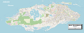
Enlargeable, detailed map of New Providence
-
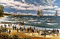
An artistic rendition of the Battle of Nassau
See also
 In Spanish: Nueva Providencia para niños
