
Newry facts for kids
Quick facts for kids Newry
|
|
|---|---|
.jpg) Top: Newry skyline, Middle: The Buttercrane, The Quays, Newry Town Hall, Bottom: Drumalane Mill, Newry Cathedral |
|

Newry
|
|
| Population | 26,967 (2011 Census) |
| Irish grid reference | J085265 |
| District |
|
| County | |
| Country | Northern Ireland |
| Sovereign state | United Kingdom |
| Post town | NEWRY |
| Postcode district | BT34, BT35 |
| Dialling code | 028 |
| Police | Northern Ireland |
| Fire | Northern Ireland |
| Ambulance | Northern Ireland |
| EU Parliament | Northern Ireland |
| UK Parliament |
|
| Website | www.newrymournedown.org |
Newry ( from Irish: An Iúraigh) is a city in Northern Ireland, divided by the Clanrye river in counties Armagh and Down, 34 miles (55 km) from Belfast and 67 miles (108 km) from Dublin. It had a population of 26,967 in 2011.
Newry was founded in 1144 alongside a Cistercian monastery, although there are references to earlier settlements in the area, and is one of Ireland's oldest towns. The city is an entry to the "Gap of the North", five miles (eight kilometres) from the border with the Republic of Ireland. It grew as a market town and a garrison and became a port in 1742 when it was linked to Lough Neagh by the first summit-level canal built in Ireland or Great Britain. A cathedral city, it is the episcopal seat of the Roman Catholic Diocese of Dromore. In 2002, as part of Queen Elizabeth's Golden Jubilee celebrations, Newry was granted city status along with Lisburn.
Contents
Name
The name Newry is an anglicization of An Iúraigh, an oblique form of An Iúrach, which means "the grove of yew trees".
The modern Irish name for Newry is An tIúr, which means "the yew tree". An tIúr is an shortening of Iúr Cinn Trá, "yew tree at the head of the strand", which was formerly the most common Irish name for Newry. This relates to an apocryphal story that Saint Patrick planted a yew tree there in the 5th century.
The Irish name Cathair an Iúir (City of Newry) appears on some bilingual signs around the city.
History


There is strong evidence of continual human habitation in the area from early times, where it is seen during the Bronze Age that Newry had a factory type community who were producing in abundance very detailed jewellery for garments, three of these Newry Clasps can be found in the Ulster Museum, and a massive arm clasp from this same period was also found in Newry. In recent times the survey for the new bypass revealed a number of standing stones on a central area down the O Meath road, these like many other finds, like that of ancient cave at the top of the Dublin Road area, have seemingly been noted and forgotten about, it is estimated that as many as 130 ancient sites were discovered at the top of the Camlough Road amongst these there were 3 Neolithic homesteads were discovered at which time in the all were noted, and left to be destroyed by the New road, standing stones were also seen on at least one of these sites, they stand no more. In 820, the Danes made one of their earliest irruptions at Newry abbey, from whence they proceeded to Armagh, taking it by storm, and plundering and desolating the country around.
In A.D 835, according to O Halloran's History of Ireland, the Danes again made a sudden incursion into Newry, with a large body of Danes landed at Inbher-Chin-Tra-gha, or Newry, and committed, dreadful cruelties there. Then, they attacked Armagh, and set fire to the churches and university, plundering them of all their plate and riches and plundered all in his way setting fire to them, putting at the same time to the sword, above a thousand people, clergy and laity were slaughtered. Todd James Henthorn tells us more in his 1867 Volume, (Chronicles and memories of England and Ireland in the Middle Ages) where he tells us the abbey was attacked in 824. A small medieval town was in situ to the North and South of the abbey which was refounded in 1142 (Keating G) by King O Carroll of the Oriel on the request of Saint Malachi (Ibid). The landing stage of the abbey was situated to the North of the college in Killmorey street, from these early times it was the main pier and port of the town. It stayed as such until the construction of the new canal took place. The abbey was later converted to a collegiate church in 1543, before being surrendered to the crown in 1548. The abbey is seen to be giving its earnings to the crown almost 200 years before this date. It is described as being one of the richest and largest in Ireland. The Vikings attacked the Abbey many time, slaughtering its occupants. The town was granted its first charter between 1157 by High King of Ireland Muirchertach Mac Lochlainn. many believe that this charter is in fact a 17cent fake compiled by Ware as it reads no different that the Melifont charter there is also some argument that the latter was built before Newry which can really hold no water as Melifont was a new structure.
In 1162 the monastery was attacked and burned to some degree, by Irish clans. There is no evidence however as to how much of the abbey was burned in this attack stones don't burn so it was not completely destroyed as may be assumed. De Courcy's lordship ensured a safe spell for the abbey after he had built several castles in and around Newry, these were typical Norman affairs Motte and Baileys.
In 1539 an English mercenary, Nicholas Bagenal, fled to Ireland after murdering a man in Leek, Staffordshire, apparently with the aid of his two brothers. After some time in the employment of the O Neill he reached a high status, was granted a pardon in 1543, and became Marshal of the army. During his early years in the Louth area he lived at Carlingford where his son Henry was born. Lord Bingham is seen sending Oriel labourers to Newry in 1546 at which time Bagenal is seen restoring the castle of Newry which belonged to Hugh O Neill being first built by John De Courcy in 1186 (De Arcy McGee See also Lewis 1815) Not long after this the Marshall in 1552 is seen securing a 21-year lease on the Newry property which was confiscated from the Cistercians the Castle was then pulled to the ground by Shane O Neill who banished Bagenal from Newry in 1566.
Many of the old walls of the Abbey are still standing round the abbey fields. The nearby convent was also part of the Abbey,and is seen mentioned in the Bagenal patent. A small medieval church can be found in its grounds. It is an ancient place. The abbey site is mentioned in the rent rolls of 1575, said to consist of a 'church, a steeple, a cemetery, a chapter-house, dormitory and hall, two orchards and one garden, containing one acre, within the precincts of the college which was situated at Killmorey street on the site of the old gas works.
During the 1689 Raid on Newry Williamite forces under Toby Purcell repulsed an attack by the Jacobites under the Marquis de Boisseleau. At the period of the Battle of the Boyne, the Duke of Berwick set fire to the parts of the town which he had restructured to defend it, see Berwicks Journal, Schomberg sent troops in during the early hours of the mornings when seeing the flames, they successfully extinguished them. While it is believed that King William may have stayed at a Newry Castle,the story is a far fetched one, King William took a portable wooden bed room with him on this campaign,which he called his coach, (see The Impartial History by Rev Story) the King refused to sleep in Castles or houses, preferring to be amongst his men.
One of the main Castles of Newry at this date was an ancient abbey building which stood at Mill Street corner, it stood in the North West end of the abbey complex, its remains were finally demolished in 1965. The other abbey buildings were once used by Bagenal (30 odd years), as pig sties and stables according to the O Neill web site, these buildings lay neglected when King William passed through the town, for over 100 years they were nothing more than great massive stores or sheds in the back ground and not considered as part of the town. Isaac Corry demolished some of them in the early 1800s the ones that he didn't demolish were turned into home steads or ware houses this included the 140 feet of the great church that was constructed in 1142 he demolished the altar of the same and completely dug up the ancient grave yard that was beside the church removing ancient bones by the cart load to St Mary's at Chapel street while there was deep mourning from the Catholics of the town at these action no one complained because of Corry's status. The grave yard is currently a car park for Lidl the great church is now a museum Bagenal Castle.
By 1881 the population of Newry had reached 15,590. Newry Urban District Council was unusual in that during the period from the 1920s to the 1960s it was one of only a handful of councils in Northern Ireland which had a majority of Councillors from the Catholic/Nationalist community. (The others were Strabane UDC and a handful of rural district councils.) The reason according to Michael Farrell was that this community formed such a large majority in the town, around 80% of the population, that it was impossible to gerrymander. Also an oddity was that for a time it was controlled by the Irish Labour Party, after the left wing of the Northern Ireland Labour Party defected to them in the 1940s.
The Troubles
Newry saw several violent incidents during the conflict known as the Troubles. These went on into the late 1990s and even in 2010 – such as bomb scares and car bombs.
See also: The Troubles in Killeen, for information on incidents at the border and customs post at Newry on the border with the Republic of Ireland and close to Newry. In 2003, the hilltop watch towers were taken down. The Army withdrew from the area on 25 June 2007 when they closed their final base at Bessbrook. As there are no garrisons in the area the British Army has had no official presence in Newry or South Armagh since the end of Operation Banner.
Geography
Newry lies in the most south-eastern part of both Ulster and Northern Ireland. About half of the city (the west) lies in County Armagh and the other half (the east) in County Down. The Clanrye River, which runs through the city, forms the historic border between County Armagh and County Down.
The city sits in a valley, between the Mourne Mountains to the east and the Ring of Gullion to the south-west, both of which are designated Areas of Outstanding Natural Beauty. The Cooley Mountains lie to the south east. The Clanrye River runs through the centre of town, parallel to the Newry Canal. The city also lies at the northernmost end of Carlingford Lough, where the canal enters the sea at Victoria Locks.
Townlands
Newry is within the civil parishes of Newry and Middle Killeavy. The parishes have long been divided into townlands, the names of which mainly come from the Irish language. The following is a list of townlands in Newry's urban area, alongside their likely etymologies:
| Townland | Origin (Irish unless stated) | Translation |
|---|---|---|
| Altnaveigh Aghnaveigh (alternate local name) |
Alt na bhFiach Achadh na bhFiach |
glen of the ravens field of the ravens |
| Ballinlare | Baile na Ladhaire | townland of the fork/gap |
| Carnagat | Carn na gCat | cairn of the cats |
| Carnbane | Carn Bán | white cairn |
| Derry Beg | Doire Beag | little oak wood |
| Drumalane | An Droim Leathan | broad ridge |
| Lisdrumgullion | Lios Droim gCuilinn | fort of the holly ridge |
| Lisdrumliska | Lios Druim Loiscthe | fort of the burnt ridge |
| Townland | Origin (Irish unless stated) | Translation |
|---|---|---|
| Ballynacraig | Baile na gCreag | townland of the crags |
| Ballinaire | Baile an Iubhair | settlement of the yew tree |
| Carneyhough | Cárn Uí h-Eochadha OHaughey[s] Carn | |
| Cloghanramer | Clochán Ramhar | thick stone structure/causeway |
| Commons | an English name that first appeared in 1810 | |
| Creeve | Craobh | tree/bush |
| Damolly | probably Damh Maoile | house of the round hill |
| Drumcashellone | Droim Caisil Eoghain | the ridge of Eoghan's cashel |
| Greenan | Grianán | eminent or sunny place |
Demography
On Census day (27 March 2011) there were 26,967 people living in Newry, accounting for 1.49% of the NI total. Of these:
- 21.46% were aged under 16 years and 12.74% were aged 65 and over;
- 51.02% of the usually resident population were female and 48.98% were male;
- 88.27% belong to or were brought up in the Catholic religion and 8.47% belong to or were brought up in a 'Protestant and Other Christian (including Christian related)' religion;
- 56.12% had an Irish national identity, 27.27% had a Northern Irish national identity and 12.65% indicated that they had a British national identity (respondents could indicate more than one national identity);
- 35 years was the average (median) age of the population;
- 19.60% had some knowledge of Irish (Gaelic) and 2.37% had some knowledge of Ulster-Scots.
Climate
As with the rest of Ireland, Newry has a temperate climate, with a narrow range of temperatures, regular windy conditions, and rainfall throughout the year.
| Climate data for Newry, United Kingdom (1981–2010 normals) | |||||||||||||
|---|---|---|---|---|---|---|---|---|---|---|---|---|---|
| Month | Jan | Feb | Mar | Apr | May | Jun | Jul | Aug | Sep | Oct | Nov | Dec | Year |
| Average high °C (°F) | 6.8 (44.2) |
7.1 (44.8) |
9.2 (48.6) |
11.5 (52.7) |
14.5 (58.1) |
17.0 (62.6) |
18.7 (65.7) |
18.3 (64.9) |
15.9 (60.6) |
12.4 (54.3) |
9.1 (48.4) |
6.9 (44.4) |
12.3 (54.1) |
| Average low °C (°F) | 1.7 (35.1) |
1.8 (35.2) |
2.8 (37.0) |
4.2 (39.6) |
6.5 (43.7) |
9.3 (48.7) |
11.2 (52.2) |
11.1 (52.0) |
9.2 (48.6) |
6.7 (44.1) |
4.0 (39.2) |
2.2 (36.0) |
5.9 (42.6) |
| Average precipitation mm (inches) | 108.9 (4.29) |
74.9 (2.95) |
84.5 (3.33) |
74.5 (2.93) |
68.3 (2.69) |
64.6 (2.54) |
74.7 (2.94) |
82.7 (3.26) |
77.5 (3.05) |
104.8 (4.13) |
100.0 (3.94) |
103.2 (4.06) |
1,018.7 (40.11) |
| Source: Met Office (UK) | |||||||||||||
Transport
Transport history
The Newry Canal, which opened in 1742, is the oldest canal in Ireland or Britain and when functioning as an inland transport waterway, it ran for 18 miles (29 kilometres) to Lough Neagh. Some surviving 18th and 19th century warehouses still line the canal, with some containing shops and restaurants.
In 1885 an electric tramway, the Bessbrook and Newry Tramway, was opened between Newry and Bessbrook.
MacNeill's Egyptian Arch is a railway bridge located near Newry. It was selected for the design of the British One Pound coin to represent Northern Ireland for 2006.
Services
Newry railway station, just off the Camlough road, offers cross border services on the Dublin-Belfast line as well as some regional services around areas of County Armagh and County Down. Transport to other places generally requires a change in either Belfast or Dublin. Planning permission for the construction of a new station to the east of the current station, was granted in May 2006 and the new station opened on 7 September 2009 by Northern Ireland Railways.
In terms of bus transport, Newry is served by an Ulsterbus bus station in the city centre. The bus station is located along The Mall, suspended over the Clanrye River. Services in Newry include local, regional and cross-border transport with a free shuttle bus service to the local train station and services to local schools around Newry and Mourne.
Newry is on the main M1/A1 route from Dublin to Belfast. Originally the route passed through the town centre, but in the 60s was bypassed by the Abbey Link. This remained the sole relief road until 1996 when it was superseded by a single carriageway bypass round the western side of the town. By 2008 the road on either side of the town had been upgraded to motorway/high quality dual carriageway standard (southwards from Cloghogue) and low quality dual carriageway (northwards from Beechill). In July 2010 a new high quality dual carriageway with motorway characteristics was opened to bridge the gap, thus connecting Dublin with Belfast by motorway/dual carriageway for the first time. The opening of this section of Road meant that motorists could travel from Clogh in County Antrim to Midleton, County Cork by dual carriageway/motorway. Part of this older bypass is still in use between the Camlough Road (A25) and the Belfast Road (A1). Newry suffers from very heavy traffic with shoppers coming from across the border. Newry is connected with Warrenpoint by a lower quality dual carriageway, some seven miles (eleven kilometres) to the south.
Newry is linked to Belfast via National Cycle Route 9, via Portadown, Lisburn and Craigavon.
Notable people
Arts and media
- Christine Bleakley, television host
- Margaret Clarke, (1884–1961), portrait painter
- Thomas Duff, (1792–1848), architect
- Julia Glover, 18th and 19th century stage actress
- Frank Hall, (1921–1995), broadcaster and satirist
- Seán Hillen, photographer and artist
- Valene Kane, actress
- Michael Legge, actor
- Actor siblings John and Susan Lynch
- Tomm Moore, filmmaker
- Gerard Murphy, actor
Groups
- The 4 of Us – rock band
- Luv Bug, pop group
- Crubeen, a 1970s folk band
Religion
- John Dunlop, Presbyterian churchman
- John Magee, Roman Catholic Bishop of Cloyne
Academia and science
- Leonard Abrahamson (1896-1961), cardiologist
- Joseph Barcroft (1872–1947), respiratory physiologist
- W. J. Barre (1830–1867), architect.
- Elizabeth Gould Bell (1862–1934), doctor
Sport
- Shay McCartan, footballer
- Michael Cusack (1847–1906), founder of the Gaelic Athletic Association
- Pat Jennings, footballer
- Willie Maley (1868 – 1958), football manager
- Danny McAlinden, heavyweight boxer
- Ryan McGivern, footballer
- Terence Bannon, Mountaineer
- Peter McParland, footballer
- Seán O'Neill, Gaelic footballer
- Ronan Rafferty, golfer
Economy
Newry has a reputation as one of the best provincial shopping-towns in Northern Ireland, with the Buttercrane Centre and The Quays Newry attracting large numbers of shoppers from as far away as Cork.
In 2006 Newry house prices grew the most across the whole United Kingdom over the previous decade, as prices in the city had increased by 371% since 1996. The city itself has become markedly more prosperous in recent years. Unemployment has reduced from over 26% in 1991 to scarcely 2% in 2008.
Since the inception of the global financial crisis of 2008–2009, residents of the Republic of Ireland have increasingly been cross-border shopping to Newry to buy cheaper goods due to the difference in currency. The harsh budget in the Republic of Ireland in October 2008, and the growing strength of the euro against the pound sterling and VAT reductions in the United Kingdom, compared with increases in the Republic of Ireland, are among the reasons. This remarkable increase in cross-border trade has become so widespread that it has lent its name to a general phenomenon known as the Newry effect. In December 2008, The New York Times described Newry as "the hottest shopping spot within the European Union's open borders, a place where consumers armed with euros enjoy a currency discount averaging 30 percent or more".
However the increased flow of trade has led to resultant tailbacks, sometimes several miles long (many kilometres), on approach roads from the south. This has created huge traffic and parking problems in Newry and the surrounding area. It has also become a political issue, with some politicians in the Republic of Ireland claiming that such cross-border shopping is "unpatriotic".
Newry is the global HQ of FD Technologies Plc.
Sport
Football
Until 2012, Newry City F.C. played at the Showgrounds before being liquidated. A phoenix club named Newry City AFC was formed to play in amateur leagues in 2013, and was promoted to the NIFL Premiership in 2018.
Gaelic Athletic Association
The Down GAA team has its home ground at Páirc Esler in the city. Local clubs, within the Down GAA area, include Newry Bosco GFC, Newry Shamrocks GAC, John Mitchel GFC.
GAA clubs, within the Armagh GAA area, include Thomas Davis GFC, Corrinshego and Killeavy St Moninna's GAC.
Rugby Union
Newry RFC (also known as Newry Rugby Club, Newry RFU or Newry) is an Irish amateur rugby union club, founded in 1925. The club is a member of the Irish Rugby Football Union's Ulster branch. The club currently fields three senior teams and several junior teams ranging from under-12 to under-18 and a women's team for the first time in 2010–2011 season. The club's home ground is known as Telford Park. The team currently has two playing fields located at this ground along with the clubhouse on the outskirts of Newry.
Education
There are approximately 10 primary schools in the area, including Killean Primary School and St Malachy's Primary School.
Local post-primary schools include Abbey Christian Brothers Grammar School, Newry High School, Our Lady's Grammar School, Sacred Heart Grammar School, St Colman's College, St Joseph's Boys' High School, St. Mary's High School and St. Paul's High School, Bessbrook.
Southern Regional College, a further and higher education college, has campus facilities in Newry.
Images for kids
-
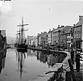
Merchants Quay, Newry, in the late 19th century
-
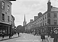
Hill Street in the early 1900s
-
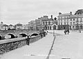
Trevor Hill in the early 1900s
-
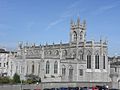
Catholic Cathedral of SS. Patrick and Colman, Newry

.jpg)
.jpg)

See also
 In Spanish: Newry (Irlanda del Norte) para niños
