
Niagara Falls facts for kids

Niagara Falls is the group name of three big waterfalls on the Niagara River in eastern North America, on the border between the United States and Canada. The three waterfalls are: the Horseshoe Falls, sometimes called the Canadian Falls, the American Falls, and the smaller Bridal Veil Falls. The American Falls and the Horseshoe Falls are separated with Goat Island, and the Bridal Veil Falls separated from the other waterfalls with Luna Island.
Niagara Falls were formed when glaciers receded at the end of the Wisconsin glaciation (the last ice age), and water from the newly formed Great Lakes carved a path through the Niagara Escarpment en route to the Atlantic Ocean.
Although not very high, Niagara Falls is very wide, and is probably the most popular waterfall in the world. The Horseshoe Falls are the largest out of the three falls. It is named the Horseshoe Falls because it looks like a horseshoe.
Niagara Falls is a very popular tourist place and many people visit it on holiday in Canada.
Contents
Characteristics


The Horseshoe Falls drop about 57 metres (187 ft), while the height of the American Falls varies between 21 and 30 metres (69 and 98 ft) because of the presence of giant boulders at its base. The larger Horseshoe Falls are about 790 metres (2,590 ft) wide, while the American Falls are 320 metres (1,050 ft) wide. The distance between the American extremity of the Niagara Falls and the Canadian extremity is 3,409 feet (1,039 m).
The peak flow over Horseshoe Falls was recorded at 6,400 cubic metres (230,000 cu ft) per second. The average annual flow rate is 2,400 cubic metres (85,000 cu ft) per second. Since the flow is a direct function of the Lake Erie water elevation, it typically peaks in late spring or early summer. During the summer months, at least 2,800 cubic metres (99,000 cu ft) per second of water traverses the falls, some 90% of which goes over the Horseshoe Falls, while the balance is diverted to hydroelectric facilities. This is accomplished by employing a weir – the International Control Dam – with movable gates upstream from the Horseshoe Falls. The falls' flow is further halved at night, and, during the low tourist season in the winter, remains a minimum of 1,400 cubic metres (49,000 cu ft) per second. Water diversion is regulated by the 1950 Niagara Treaty and is administered by the International Niagara Board of Control (IJC).
The verdant green colour of the water flowing over the Niagara Falls is a byproduct of the estimated 60 tonnes/minute of dissolved salts and "rock flour" (very finely ground rock) generated by the erosive force of the Niagara River itself.
Geology
The features that became Niagara Falls were created by the Wisconsin glaciation about 10,000 years ago. The same forces also created the North American Great Lakes and the Niagara River. All were dug by a continental ice sheet that drove through the area, deepening some river channels to form lakes, and damming others with debris. Scientists argue there is an old valley, St David's Buried Gorge, buried by glacial drift, at the approximate location of the present Welland Canal.

When the ice melted, the upper Great Lakes emptied into the Niagara River, which followed the rearranged topography across the Niagara Escarpment. In time, the river cut a gorge through the north-facing cliff, or cuesta. Because of the interactions of three major rock formations, the rocky bed did not erode evenly. The top rock formation was composed of erosion-resistant limestone and Lockport dolostone. That hard layer of stone eroded more slowly than the underlying materials. The aerial photo on the right clearly shows the hard caprock, the Lockport Formation (Middle Silurian), which underlies the rapids above the falls, and approximately the upper third of the high gorge wall.
Immediately below the hard-rock formation, comprising about two-thirds of the cliff, lay the weaker, softer, sloping Rochester Formation (Lower Silurian). This formation was composed mainly of shale, though it has some thin limestone layers. It also contains ancient fossils. In time, the river eroded the soft layer that supported the hard layers, undercutting the hard caprock, which gave way in great chunks. This process repeated countless times, eventually carving out the falls.
Submerged in the river in the lower valley, hidden from view, is the Queenston Formation (Upper Ordovician), which is composed of shales and fine sandstones. All three formations were laid down in an ancient sea, their differences of character deriving from changing conditions within that sea.
About 10,900 years ago, the Niagara Falls was between present-day Queenston, Ontario, and Lewiston, New York, but erosion of their crest has caused the waterfalls to retreat approximately 6.8 miles (10.9 km) southward. The Horseshoe Falls, which are about 2,600 feet (790 m) wide, have also changed their shape through the process of erosion; evolving from a small arch to a horseshoe bend, to the present day gigantic V. Just upstream from the falls' current location, Goat Island splits the course of the Niagara River, resulting in the separation of the mostly Canadian Horseshoe Falls to the west from the American and Bridal Veil Falls to the east. Engineering has slowed erosion and recession.
The current rate of erosion is approximately 30 centimeters (1 ft) per year, down from a historical average of 0.91 m (3 ft) per year. According to the timeline of the far future, in roughly 50,000 years Niagara Falls will have eroded the remaining 32 kilometres (20 mi) to Lake Erie and cease to exist.
History


Theories differ as to the origin of the name of the falls. According to Iroquoian scholar Bruce Trigger, Niagara is derived from the name given to a branch of the local native Neutral Confederacy, who are described as being called the Niagagarega people on several late-17th-century French maps of the area. According to George R. Stewart, it comes from the name of an Iroquois town called Onguiaahra, meaning "point of land cut in two".
Many figures have been suggested as first circulating a European eyewitness description of Niagara Falls. The Frenchman Samuel de Champlain visited the area as early as 1604 during his exploration of Canada, and members of his party reported to him the spectacular waterfalls, which he described in his journals. The Finnish-Swedish naturalist Pehr Kalm explored the area in the early 18th century and is credited with the first scientific description of the falls. The consensus honoree for the first description is the Belgian missionary Louis Hennepin, who observed and described the falls in 1677, earlier than Kalm, after traveling with the explorer René-Robert Cavelier, Sieur de La Salle, thus bringing the falls to the attention of Europeans. Further complicating matters, there is credible evidence the French Jesuit missionary Paul Ragueneau visited the falls some 35 years before Hennepin's visit while working among the Huron First Nation in Canada. Jean de Brébeuf also may have visited the falls, while spending time with the Neutral Nation.

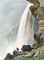
.jpg)
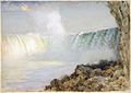
In 1762, Captain Thomas Davies, a British Army officer and artist, surveyed the area and painted the watercolor, An East View of the Great Cataract of Niagara, the first eyewitness painting of the falls.
During the 19th century, tourism became popular, and by mid-century, it was the area's main industry. Theodosia Burr Alston (daughter of Vice President Aaron Burr) and her husband Joseph Alston were the first recorded couple to honeymoon there in 1801. Napoleon Bonaparte's brother Jérôme visited with his bride in the early 19th century.
In 1837 during the Caroline affair, a rebel supply ship, the Caroline, was burned and sent over the falls. In March 1848, ice blockage caused the falls to stop; no water (or at best a trickle) fell for as much as 40 hours. Waterwheels stopped, mills and factories shut down for having no power.
Later that year, demand for passage over the Niagara River led to the building of a footbridge and then Charles Ellet's Niagara Suspension Bridge. This was supplanted by German-born John Augustus Roebling's Niagara Falls Suspension Bridge in 1855. After the American Civil War, the New York Central Railroad publicized Niagara Falls as a focus of pleasure and honeymoon visits. With increased railroad traffic, in 1886, Leffert Buck replaced Roebling's wood and stone bridge with the predominantly steel bridge that still carries trains over the Niagara River today. The first steel archway bridge near the falls was completed in 1897. Known today as the Whirlpool Rapids Bridge, it carries passenger vehicles and trains between Canada (through Canadian Customs Border Control) and the U.S.A. just downstream of the falls.
In about 1840, the English industrial chemist Hugh Lee Pattinson traveled to Canada, stopping at the Niagara Falls long enough to make the earliest known photograph of the falls, a daguerreotype in the collection of Newcastle University. It was once believed that the small figure standing silhouetted with a top hat was added by an engraver working from imagination as well as the daguerreotype as his source, but the figure is clearly present in the photograph. Because of the very long exposure required, of ten minutes or more, the figure is assumed by Canada's Niagara Parks agency to be Pattinson himself. The image is left-right inverted and taken from the Canadian side. Pattinson made other photographs of the Horseshoe Falls as well as of Rome and Paris. These were then transferred to engravings to illustrate Noël Marie Paymal Lerebours' Excursions Daguerriennes (Paris, 1841–1864).
After the First World War, tourism boomed again, as automobiles made getting to the falls much easier. The story of Niagara Falls in the 20th century is largely that of efforts to harness the energy of the falls for hydroelectric power, and to control the development on both sides that threaten the area's natural beauty.
In 1941, the Niagara Falls Bridge Commission completed the third current crossing in the immediate area of Niagara Falls with the Rainbow Bridge, carrying both pedestrian and vehicular traffic between the two countries and Canadian and U.S. customs for each country.
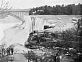
A team from the U.S. Army Corps of Engineers created a dam on the American Falls in June 1969 to clear rock from the base of the falls. Rock slides caused a significant buildup of rock at the bottom of the American side of the falls, and the engineers were to clean up the rock and repair some faults to prevent eventual erosion of the American side of the waterfall. A temporary dam was built to divert the flow of water to the Canadian side; the dam measured 600 ft (180 m) across and was made of nearly 30,000 tons of rock. The engineers cleared the rock debris and tested for safety, finishing the project in November of that year. Water flow was restored on November 25, 1969.
Before the late 20th century, the northeastern end of the Horseshoe Falls was in the United States, flowing around the Terrapin Rocks, which were once connected to Goat Island by a series of bridges. In 1955, the area between the rocks and Goat Island was filled in, creating Terrapin Point. In the early 1980s, the U.S. Army Corps of Engineers filled in more land and built diversion dams and retaining walls to force the water away from Terrapin Point. Altogether, 400 ft (120 m) of the Horseshoe Falls were eliminated, including 100 ft (30 m) on the Canadian side. According to author Ginger Strand, the Horseshoe Falls is now entirely in Canada. Other sources say "most of" Horseshoe Falls is in Canada.
History of freezing over
The only recorded freeze-up of the river and falls was due to an ice jam on March 29, 1848. Although the falls commonly ice up most winters, the river and the falls do not freeze completely. The years 1885, 1902, 1906, 1911, 1932, 1936, 2014 and 2017 are noted for the falls icing up. In 1912, much of the water coming over the American Falls froze, though a trickle still ran and the falls ran at the other two sites.
Impact on industry and commerce
Hydroelectric power


The enormous energy of Niagara Falls has long been recognized as a potential source of power. The first known effort to harness the waters was in 1759, when Daniel Joncaire built a small canal above the falls to power his sawmill. Augustus and Peter Porter purchased this area and all of American Falls in 1805 from the New York state government, and enlarged the original canal to provide hydraulic power for their gristmill and tannery. In 1853, the Niagara Falls Hydraulic Power and Mining Company was chartered, which eventually constructed the canals that would be used to generate electricity. In 1881, under the leadership of Jacob F. Schoellkopf, the Niagara River's first hydroelectric generating station was built. The water fell 86 feet (26 m) and generated direct current electricity, which ran the machinery of local mills and lit up some of the village streets.
The most powerful hydroelectric stations on the Niagara River are the Sir Adam Beck 1 and 2 on the Canadian side and the Robert Moses Niagara Power Plant and the Lewiston Pump Generating Plant on the American side. Together, Niagara's generating stations can produce about 4.4 gigawatts of power.
In August 2005 Ontario Power Generation, which is responsible for the Sir Adam Beck stations, started a major civil engineering project, called the Niagara Tunnel Project, to increase power production by building a new 12.7-metre (42 ft) diameter, 10.2-kilometre-long (6.3 mi) water diversion tunnel. It was officially placed into service in March 2013, helping to increase the generating complex's nameplate capacity by 150 megawatts. It did so by tapping water from farther up the Niagara River than was possible with the preexisting arrangement. The tunnel provided new hydroelectricity for approximately 160,000 homes.
Transport

Ships can bypass Niagara Falls by means of the Welland Canal, which was improved and incorporated into the Saint Lawrence Seaway in the mid-1950s. While the seaway diverted water traffic from nearby Buffalo and led to the demise of its steel and grain mills, other industries in the Niagara River valley flourished with the help of the electric power produced by the river. However, since the 1970s the region has declined economically.
The cities of Niagara Falls, Ontario, Canada, and Niagara Falls, New York, United States, are connected by two international bridges. The Rainbow Bridge, just downriver from the falls, affords the closest view of the falls and is open to non-commercial vehicle traffic and pedestrians. The Whirlpool Rapids Bridge lies one mile (1.6 km) north of the Rainbow Bridge and is the oldest bridge over the Niagara River. Nearby Niagara Falls International Airport and Buffalo Niagara International Airport were named after the waterfall, as were Niagara University, countless local businesses, and even an asteroid.
Tourism

Peak visitor traffic occurs in the summertime, when Niagara Falls are both a daytime and evening attraction. From the Canadian side, floodlights illuminate both sides of the falls for several hours after dark (until midnight). The number of visitors in 2007 was expected to total 20 million, and by 2009 the annual rate was expected to top 28 million tourists.
The oldest and best known tourist attraction at Niagara Falls is the Maid of the Mist boat cruise, named for an ancient Ongiara Indian mythical character, which has carried passengers into the rapids immediately below the falls since 1846. Cruise boats operate from boat docks on both sides of the falls, with the Maid of the Mist operating from the American side and Hornblower Cruises from the Canadian side.
American side

From the U.S. side, the American Falls can be viewed from walkways along Prospect Point Park, which also features the Prospect Point Observation Tower and a boat dock for the Maid of the Mist. Goat Island offers more views of the falls and is accessible by foot and automobile traffic by bridge above the American Falls. From Goat Island, the Cave of the Winds is accessible by elevator and leads hikers to a point beneath Bridal Veil Falls. Also on Goat Island are the Three Sisters Islands, the Power Portal where a huge statue of Nikola Tesla (the inventor whose patents for the AC induction motor and other devices for AC power transmission helped make the harnessing of the falls possible) can be seen, and a walking path that enables views of the rapids, the Niagara River, the gorge, and all of the falls. Most of these attractions lie within the Niagara Falls State Park.
The Niagara Scenic Trolley offers guided trips along the American Falls and around Goat Island. Panoramic and aerial views of the falls can also be viewed by helicopter. The Niagara Gorge Discovery Center showcases the natural and local history of Niagara Falls and the Niagara Gorge. A casino and luxury hotel was opened in Niagara Falls, New York, by the Seneca Indian tribe. The Seneca Niagara Casino & Hotel occupies the former Niagara Falls Convention Center. The new hotel is the first addition to the city's skyline since completion of the United Office Building in the 1920s.
Canadian side
On the Canadian side, Queen Victoria Park features manicured gardens, platforms offering views of both the American and Horseshoe Falls, and underground walkways leading into observation rooms that yield the illusion of being within the falling waters. The observation deck of the nearby Skylon Tower offers the highest view of the falls, and in the opposite direction gives views as far as Toronto. Along with the Minolta Tower (formerly the Seagrams Tower and the Konica Minolta Tower, and since 2010 called the Tower Hotel), it is one of two towers in Canada with a view of the falls.
Along the Niagara River, the Niagara River Recreational Trail runs 35 miles (56 km) from Fort Erie to Fort George, and includes many historical sites from the War of 1812.
The Whirlpool Aero Car, built in 1916 from a design by Spanish engineer Leonardo Torres y Quevedo, is a cable car that takes passengers over the Niagara Whirlpool on the Canadian side. The Journey Behind the Falls consists of an observation platform and series of tunnels near the bottom of the Horseshoe Falls on the Canadian side.
There are two casinos on the Canadian side of Niagara Falls, the Niagara Fallsview Casino Resort and Casino Niagara.
Panoramic views
.jpg)


Related pages
Images for kids
-
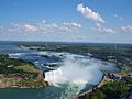
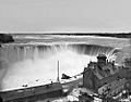
Canadian Horseshoe Falls at right
-
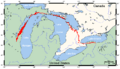
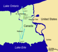
Niagara Escarpment (in red). Niagara Falls is center-right between Lake Ontario and Lake Erie.
-
Damage from wind and ice on Goat Island, 1903
-
American Falls diverted during erosion control efforts in 1969
-
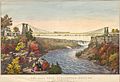
Horseshoe Falls, 1869
-
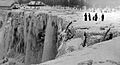
American Falls frozen over with people on the ice, 1911
-
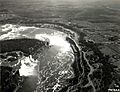
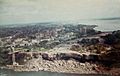
Aerial photograph of Niagara Falls, 1931
-
Hand-colored lithograph of the (double-decked) Niagara Suspension Bridge, c. 1856
-
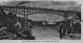
Niagara Cantilever Bridge, c. 1895
-
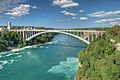
The Rainbow Bridge, the first bridge downstream from the falls
-
The Welland Canal connects Lake Ontario and Lake Erie through a series of eight locks, allowing ships to bypass the 51 m (167 ft) high Niagara Falls
-
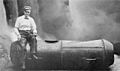
Bobby Leach and his barrel after his trip over Niagara Falls, (1911 photo)
-
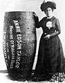
Annie Edson Taylor posing with her wooden barrel (1901)
-

Blondin carrying his manager, Harry Colcord, on a tightrope
-
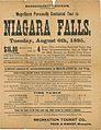
Advertising broadside for trip to Niagara Falls from Massachusetts, 1895
-
Prospect Point Observation Tower (also known as the Niagara Falls Observation Tower)
-
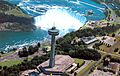
Skylon Tower as seen from a helicopter on the Canadian side
-

The opening title from the theatrical trailer of the 1953 film Niagara.
-
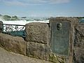
José María Heredia y Heredia plaque at Table Rock
-
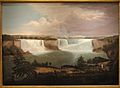
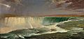
A General View of the Falls of Niagara by Alvan Fisher, 1820
-
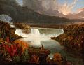
Distant View of Niagara Falls by Thomas Cole, 1830
-
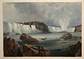
Niagara Fälle. Les chûtes du Niagara. Niagara Falls by Karl Bodmer, circa 1832
-
Voute sous la Chute du Niagara – Niagara Falls, circa 1841
-
Niagara by Frederic Edwin Church, 1857
-
Niagara by Louis Rémy Mignot, circa 1866
-
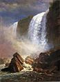
Falls of Niagara from Below by Albert Bierstadt, 1869
-
Niagara Falls, circa 1880


_(14784784605).jpg)


.jpg)


See also
 In Spanish: Cataratas del Niágara para niños
