
Nikiski, Alaska facts for kids
Quick facts for kids
Nikiski, Alaska
|
|
|---|---|
 |
|

Location of Nikiski, Alaska
|
|
| Country | United States |
| State | Alaska |
| Borough | Kenai Peninsula |
| Area | |
| • Total | 75.93 sq mi (196.65 km2) |
| • Land | 69.48 sq mi (179.94 km2) |
| • Water | 6.45 sq mi (16.71 km2) |
| Elevation | 128 ft (39 m) |
| Population
(2020)
|
|
| • Total | 4,456 |
| • Density | 64.14/sq mi (24.76/km2) |
| Time zone | UTC-9 (Alaska (AKST)) |
| • Summer (DST) | UTC-8 (AKDT) |
| ZIP code |
99635
|
| Area code(s) | 907 |
| FIPS code | 02-54050 |
| GNIS feature ID | 1416651 |
Nikiski is a census-designated place (CDP) in Kenai Peninsula Borough, Alaska, United States. The population was 4,456 at the 2020 census, down from 4,493 in 2010.
Geography
Nikiski is located at 60°42′28″N 151°15′46″W / 60.70778°N 151.26278°W (60.707891, -151.262646).
According to the United States Census Bureau, the CDP has a total area of 76.2 square miles (197 km2), of which, 69.6 square miles (180 km2) of it is land and 6.6 square miles (17 km2) of it (8.66%) is water.
The only road access is via the Kenai Spur Highway.
Demographics
| Historical population | |||
|---|---|---|---|
| Census | Pop. | %± | |
| 1880 | 74 | — | |
| 1980 | 1,109 | — | |
| 1990 | 2,743 | 147.3% | |
| 2000 | 4,327 | 57.7% | |
| 2010 | 4,493 | 3.8% | |
| 2020 | 4,456 | −0.8% | |
| U.S. Decennial Census | |||
Nikiski first appeared on the 1880 U.S. Census as the unincorporated Tinneh villages of "Kultuk" (AKA Nikishka No. 3) and "Titukilsk and Nikishka". Kultuk had a population of 17, and Titukilsk and Nikishka had a population of 57, all of whom were Tinneh Natives. There apparently were no census reports from 1880 until 1980, when the area was organized as "Nikishka" and made a census-designated place (CDP). The name was altered to "Nikiski" in 1990 and has reported as such on each successive census.
As of the census of 2000, there were 4,327 people, 1,514 households, and 1,130 families residing in the CDP. The population density was 62.2 people per square mile (24.0/km2). There were 1,766 housing units at an average density of 25.4/sq mi (9.8/km2). The racial makeup of the CDP was 87.15% White, 0.12% Black or African American, 7.56% Native American, 0.72% Asian, 0.51% Pacific Islander, 0.83% from other races, and 3.12% from two or more races. 1.32% of the population were Hispanic or Latino of any race.
There were 1,514 households, out of which 41.7% had children under the age of 18 living with them, 60.9% were married couples living together, 7.9% had a female householder with no husband present, and 25.3% were non-families. 20.8% of all households were made up of individuals, and 3.8% had someone living alone who was 65 years of age or older. The average household size was 2.86 and the average family size was 3.31.
In the CDP, the population was spread out, with 33.5% under the age of 18, 6.3% from 18 to 24, 29.8% from 25 to 44, 24.5% from 45 to 64, and 5.9% who were 65 years of age or older. The median age was 34 years. For every 100 females, there were 109.0 males. For every 100 females age 18 and over, there were 111.3 males.
The median income for a household in the CDP was $51,176, and the median income for a family was $55,969. Males had a median income of $50,673 versus $26,779 for females. The per capita income for the CDP was $20,128. About 9.3% of families and 11.4% of the population were below the poverty line, including 13.0% of those under age 18 and 7.5% of those age 65 or over.
Notable people
- Mike Chenault, longest-serving speaker of the Alaska House of Representatives
- Mike Navarre, politician
- Norman Olson, founder of two private militias
Images for kids
-
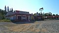
A motel from the area's boom days, now abandoned

See also
 In Spanish: Nikiski (Alaska) para niños
