
Nipomo, California facts for kids
Quick facts for kids
Nipomo
|
|
|---|---|
.jpg)
|
|

Location in San Luis Obispo County and the state of California
|
|

Nipomo, California
Location in the United States
|
|
| Country | |
| State | |
| County | San Luis Obispo |
| Named for | "Place of the big house" or "Village" |
| Area | |
| • Total | 14.852 sq mi (38.467 km2) |
| • Land | 14.852 sq mi (38.466 km2) |
| • Water | 0 sq mi (0.001 km2) 0% |
| Elevation | 331 ft (101 m) |
| Population
(2010)
|
|
| • Total | 16,714 |
| • Density | 1,125.37/sq mi (434.502/km2) |
| Time zone | UTC-8 (Pacific (PST)) |
| • Summer (DST) | UTC-7 (PDT) |
| ZIP code |
93444
|
| Area code(s) | 805 |
| FIPS code | 06-51476 |
| GNIS feature ID | 1652759 |
Nipomo (Chumash: Nipumuʔ) is a unincorporated town and census-designated place (CDP) in San Luis Obispo County, California, United States. The population was 12,626 at the 2000 census, and grew to 16,714 for the 2010 census.
Contents
Geography
Nipomo is located at 35°1′48″N 120°29′24″W / 35.03000°N 120.49000°W (35.0300, -120.4900).
According to the United States Census Bureau, the CDP has a total area of 14.9 square miles (39 km2), virtually all of it land.
Climate
This region experiences warm (but not hot) and dry summers, with no average monthly temperatures above 71.6 °F. According to the Köppen Climate Classification system, Nipomo has a warm-summer Mediterranean climate, abbreviated "Csb" on climate maps.
Demographics
2010
At the 2010 census Nipomo had a population of 16,714. The population density was 1,125.4 people per square mile (434.5/km2). The racial makeup of Nipomo was 12,281 (73.5%) White, 177 (1.1%) African American, 200 (1.2%) Native American, 421 (2.5%) Asian, 33 (0.2%) Pacific Islander, 2,821 (16.9%) from other races, and 781 (4.7%) from two or more races. Hispanic or Latino of any race were 6,645 persons (39.8%).
The census reported that 16,703 people (99.9% of the population) lived in households, 11 (0.1%) lived in non-institutionalized group quarters, and no one was institutionalized.
There were 5,474 households, 2,258 (41.2%) had children under the age of 18 living in them, 3,353 (61.3%) were opposite-sex married couples living together, 686 (12.5%) had a female householder with no husband present, 326 (6.0%) had a male householder with no wife present. There were 338 (6.2%) unmarried opposite-sex partnerships, and 49 (0.9%) same-sex married couples or partnerships. 807 households (14.7%) were one person and 346 (6.3%) had someone living alone who was 65 or older. The average household size was 3.05. There were 4,365 families (79.7% of households); the average family size was 3.35.
The age distribution was 4,422 people (26.5%) under the age of 18, 1,531 people (9.2%) aged 18 to 24, 4,058 people (24.3%) aged 25 to 44, 4,593 people (27.5%) aged 45 to 64, and 2,110 people (12.6%) who were 65 or older. The median age was 37.0 years. For every 100 females, there were 97.8 males. For every 100 females age 18 and over, there were 94.9 males.
There were 5,759 housing units at an average density of 387.8 per square mile, of the occupied units 3,898 (71.2%) were owner-occupied and 1,576 (28.8%) were rented. The homeowner vacancy rate was 1.7%; the rental vacancy rate was 3.1%. 11,583 people (69.3% of the population) lived in owner-occupied housing units and 5,120 people (30.6%) lived in rental housing units.
2000
At the 2000 census there were 12,626 people, 4,035 households, and 3,316 families in the CDP. The population density was 1,106.1 people per square mile (427.3/km2). There were 4,146 housing units at an average density of 363.2 per square mile (140.3/km2). The racial makeup of the CDP was 75.9% White, 0.6% African American, 1.3% Native American, 1.4% Asian, 0.1% Pacific Islander, 16.0% from other races, and 4.7% from two or more races. Hispanic or Latino of any race were 34.6%.
Of the 4,035 households 41.4% had children under the age of 18 living with them, 66.9% were married couples living together, 10.9% had a female householder with no husband present, and 17.8% were non-families. 13.5% of households were one person and 6.6% were one person aged 65 or older. The average household size was 3.13 and the average family size was 3.42.
The age distribution was 30.7% under the age of 18, 7.5% from 18 to 24, 27.9% from 25 to 44, 21.7% from 45 to 64, and 12.1% 65 or older. The median age was 36 years. For every 100 females, there were 97.4 males. For every 100 females age 18 and over, there were 93.2 males.
The median household income was $49,852 and the median family income was $54,338. Males had a median income of $41,288 versus $25,509 for females. The per capita income for the CDP was $18,824. About 5.6% of families and 7.3% of the population were below the poverty line, including 9.5% of those under age 18 and 6.1% of those age 65 or over.
Parks and recreation
Nipomo Community Park is seventy-four acres (30 ha) and includes hiking and horseback riding.
History

The original settlers of Nipomo were the Chumash Indians, who have lived in the area for over 9,000 years. Rancho Nipomo (the Indian word ne-po-mah meant "foot of the hill") was one of the first and largest of the Mexican land grants in San Luis Obispo County.
The founder of present-day Nipomo, William G. Dana of Boston, was a sea captain. Dana's travels led him to California where he married Maria Josefa Carrillo of Santa Barbara. In 1837, the 38,000-acre (150 km2) Rancho Nipomo was granted to Captain Dana by the Mexican governor. The Dana Adobe, created in 1839, served as an important stop for travelers on El Camino Real between Mission San Luis Obispo and Mission Santa Barbara. The adobe was a stage coach stop and became the exchange point for mail going between north and south in the first regular mail route in California. The Danas had children, of which 13 reached adulthood. They learned both English and Spanish, as well as the language of the Chumash natives.
In 1846, U.S. Army Captain John C. Fremont and his soldiers stopped at the rancho on their way south to Santa Barbara and Los Angeles. Captain Dana hosted a barbecue and gave Fremont’s men 30 fresh horses. By the 1880s the Dana descendants had built homes on the rancho and formed a town. Streets were laid out and lots were sold to the general public. The Pacific Coast Railway (narrow gauge) came to town in 1882, and trains ran through Nipomo until The Great Depression in the 1930s. By the end of 1942, the tracks had been removed for the World War II war effort.
Thousands of Blue Gum Eucalyptus trees were planted on the Nipomo Mesa in 1908 by two men who formed the Los Berros Forest Company with the idea of selling the trees as hardwood. Groves of these non-native trees still exist, even in rows as they were originally planted. These tall trees are often removed as needed for space, but also since they present a falling hazard during high winds and can suppress native flora.
Nipomo is the location of one of the most famous photographs of the Great Depression, "Migrant Mother", by Dorothea Lange. Thompson Road was originally US Highway 101, on which Lange no doubt traveled. The current US 101 freeway was constructed in the late 1950s.
Notable people
- Casey Alexander - screenwriter (SpongeBob SquarePants, Uncle Grandpa)
- Horace Grant - NBA basketball player
- Mike Lamond - StarCraft commentator better known as HuskyStarcraft
- Leigh Rubin - creator of the syndicated comic strip Rubes
- Don Siegel - film director
- Jeff McNeil - MLB baseball player for the New York Mets
Images for kids
-
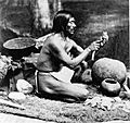
Late 19th-century photograph of Chumash chief Rafael Solares
-
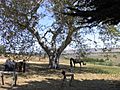
Capt. Dana Tree at the Dana Adobe.
-
The entrance to Nipomo High School


See also
 In Spanish: Nipomo para niños
