
North Bonneville, Washington facts for kids
Quick facts for kids
North Bonneville
|
|
|---|---|

City Hall in North Bonneville, February 2016
|
|

Location of North Bonneville, Washington
|
|
| Country | United States |
| State | Washington |
| County | Skamania |
| Area | |
| • Total | 2.78 sq mi (7.19 km2) |
| • Land | 2.52 sq mi (6.54 km2) |
| • Water | 0.25 sq mi (0.65 km2) |
| Elevation | 66 ft (20 m) |
| Population
(2010)
|
|
| • Total | 956 |
| • Estimate
(2019)
|
1,007 |
| • Density | 398.81/sq mi (153.99/km2) |
| Time zone | UTC-8 (Pacific (PST)) |
| • Summer (DST) | UTC-7 (PDT) |
| ZIP code |
98639
|
| Area code | 509 |
| FIPS code | 53-49555 |
| GNIS feature ID | 1531485 |
| Website | City of North Bonneville |
North Bonneville is a city in the Columbia River Gorge National Scenic Area along the Columbia River in Skamania County, Washington, United States. The population was 593 at the 2000 census and 956 at the 2010 census.
History
The community of North Bonneville developed as a construction town next to the massive Bonneville Lock, Dam, and powerhouse project begun in late 1933. Federal legislation in 1937 also authorized a second Powerhouse, although the need was not then immediate. North Bonneville was officially incorporated on June 25, 1935.
The Columbia’s north shore where North Bonneville had grown was selected by federal agencies in 1971 as the site for the second Powerhouse. Faced with the prospect of being displaced and disbanded the townspeople determined to relocate as a community. Intense efforts by citizens’ groups and planning assistance from state sources finally led to agreements with the U.S. Army Corps of Engineers to hire professionals for the design and construction of a new town. Contractors then prepared the chosen town site for the initial community of 600 people as the old town was devoured by the enormous excavation for the new powerhouse.
Federal responsibility for the North Bonneville relocation was expanded in 1974 with enactment of Public Law 93-251, referred to as the McCormack legislation. This law specifically broadened the Corps' authority and obligation in relocation assistance to North Bonneville . The $35 million relocation project included raising the new town site above the 100-year flood plain, construction of streets, utilities, lighting, sewage system, water supply and sewage treatment plant, flood protection, parks, a central business district and all public buildings. Town sitting required highway and railway relocation. And residents and business were furnished temporary housing until they could build their own permanent homes and facilities. The new town was built to accommodate 1500 residents. A celebration of the successful relocation was held July 29, 1978.
Geography
North Bonneville is located at 45°38′39″N 121°58′5″W / 45.64417°N 121.96806°W (45.644197, -121.968112).
According to the United States Census Bureau, the city has a total area of 2.62 square miles (6.79 km2), of which, 2.41 square miles (6.24 km2) is land and 0.21 square miles (0.54 km2) is water.
Climate
This region experiences warm (but not hot) and dry summers, with no average monthly temperatures above 71.6 °F. According to the Köppen Climate Classification system, North Bonneville has a warm-summer Mediterranean climate, abbreviated "Csb" on climate maps.
Demographics
| Historical population | |||
|---|---|---|---|
| Census | Pop. | %± | |
| 1940 | 643 | — | |
| 1950 | 564 | −12.3% | |
| 1960 | 494 | −12.4% | |
| 1970 | 459 | −7.1% | |
| 1980 | 394 | −14.2% | |
| 1990 | 411 | 4.3% | |
| 2000 | 593 | 44.3% | |
| 2010 | 956 | 61.2% | |
| 2019 (est.) | 1,007 | 5.3% | |
| U.S. Decennial Census | |||
2010 census
As of the census of 2010, there were 956 people, 420 households, and 262 families residing in the city. The population density was 396.7 inhabitants per square mile (153.2/km2). There were 459 housing units at an average density of 190.5 per square mile (73.6/km2). The racial makeup of the city was 94.9% White, 0.3% African American, 0.7% Native American, 1.5% Asian, 0.6% from other races, and 2.0% from two or more races. Hispanic or Latino of any race were 4.4% of the population.
There were 420 households, of which 28.6% had children under the age of 18 living with them, 45.7% were married couples living together, 10.0% had a female householder with no husband present, 6.7% had a male householder with no wife present, and 37.6% were non-families. 33.6% of all households were made up of individuals, and 11.5% had someone living alone who was 65 years of age or older. The average household size was 2.28 and the average family size was 2.86.
The median age in the city was 42.8 years. 24.1% of residents were under the age of 18; 6.1% were between the ages of 18 and 24; 22.7% were from 25 to 44; 32.5% were from 45 to 64; and 14.7% were 65 years of age or older. The gender makeup of the city was 50.2% male and 49.8% female.
Images for kids
-
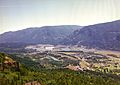
North Bonneville, Bonneville Dam, and surrounding area from Beacon Rock State Park, 1997
See also
 In Spanish: North Bonneville (Washington) para niños
