
North Hills, New York facts for kids
Quick facts for kids
North Hills, New York
|
|
|---|---|
| Incorporated Village of North Hills | |

North Hills Village Hall on September 18, 2021.
|
|
| Motto(s):
"A better place to live"
|
|

Location in Nassau County and the state of New York.
|
|

North Hills, New York
Location in New York
|
|
| Country | |
| State | |
| County | |
| Town | North Hempstead |
| Incorporated | 1929 |
| Named for | Its hilly location on Long Island's North Shore |
| Area | |
| • Total | 2.76 sq mi (7.14 km2) |
| • Land | 2.76 sq mi (7.14 km2) |
| • Water | 0.00 sq mi (0.00 km2) |
| Elevation | 217 ft (66 m) |
| Population
(2010)
|
|
| • Total | 5,075 |
| • Estimate
(2019)
|
5,969 |
| • Density | 2,165.03/sq mi (835.85/km2) |
| Time zone | UTC-5 (Eastern (EST)) |
| • Summer (DST) | UTC-4 (EDT) |
| ZIP code |
11030, 11040, 11507, 11576, 11577
|
| Area code(s) | 516 |
| FIPS code | 36-53022 |
| GNIS feature ID | 0972865 |
North Hills is a village in the Town of North Hempstead in Nassau County, on the North Shore of Long Island, in New York, United States. The population was 5,075 at the 2010 census.
Contents
Geography


North Hills is located at 40°46′33″N 73°40′22″W / 40.77583°N 73.67278°W.
According to the United States Census Bureau, the village has a total area of 2.8 square miles (7.3 km2), all of it land.
North Hills is adjacent to Interstate 495 (Long Island Expressway) and the Northern State Parkway.
History
The glacial action that formed much of Long Island deposited Shelter Rock in what is now North Hills approximately 11,000 years ago. The Matinecock had a village in the area. Farming developed in North Hills in mid 17th century. Around this time a long fence was built along the road later known as Northern Boulevard, to the North of North Hills. The lands of the Cow Neck peninsula enclosed by the fence (present day Manhasset and Port Washington) were used for grazing. Later, in the 19th century, one of the largest farms in the area was owned by I.U. Willets. The village was formed as a tax haven to prevent Manhasset from raising taxes on the property.
Demographics
| Historical population | |||
|---|---|---|---|
| Census | Pop. | %± | |
| 1930 | 339 | — | |
| 1940 | 295 | −13.0% | |
| 1950 | 330 | 11.9% | |
| 1960 | 359 | 8.8% | |
| 1970 | 295 | −17.8% | |
| 1980 | 1,587 | 438.0% | |
| 1990 | 3,453 | 117.6% | |
| 2000 | 4,301 | 24.6% | |
| 2010 | 5,075 | 18.0% | |
| 2019 (est.) | 5,969 | 17.6% | |
| U.S. Decennial Census | |||
As of the census of 2000, there were 4,301 people, 1,808 households, and 1,424 families residing in the village. The population density was 1,542.5 people per square mile (595.2/km2). There were 1,907 housing units at an average density of 683.9 per square mile (263.9/km2). The racial makeup of the village was 81.42% White, 0.91% African American, 15.83% Asian, 0.14% from other races, and 1.70% from two or more races. Hispanic or Latino of any race were 1.44% of the population.
There were 1,808 households, out of which 19.0% had children under the age of 18 living with them, 73.5% were married couples living together, 3.8% had a female householder with no husband present, and 21.2% were non-families. 18.1% of all households were made up of individuals, and 9.2% had someone living alone who was 65 years of age or older. The average household size was 2.37 and the average family size was 2.66.
In the village, the population was spread out, with 14.5% under the age of 18, 4.0% from 18 to 24, 17.2% from 25 to 44, 36.9% from 45 to 64, and 27.3% who were 65 years of age or older. The median age was 54 years. For every 100 females, there were 91.3 males. For every 100 females age 18 and over, there were 89.1 males.
The median income for a household in the village was $149,122, and the median income for a family was $184,223. Males had a median income of $100,000 versus $60,789 for females. The per capita income for the village was $100,093. About 3.4% of families and 6.3% of the population were below the poverty line, including 16.1% of those under age 18 and 6.0% of those age 65 or over.
Education
Schools
Public
North Hills is split among four public school districts. Depending on where in North Hills they reside, students attending public schools go to the Great Neck Union Free School District, the Herricks Union Free School District, the Manhasset Union Free School District, or the Roslyn Union Free School District.
Additionally, the Manhasset UFSD's Shelter Rock Elementary School is located within the village.
Private
The Buckley Country Day School is located within North Hills.
Library districts
North Hills is split among four library districts. The Great Neck Library District serves the portions of North Hills zoned for the Great Neck UFSD, the Manhasset Library District served the areas zoned for the Manhasset UFSD, Roslyn's library district (the Bryant Library) serves the areas zoned for the Roslyn UFSD, and the Shelter Rock Library District serves the areas zoned for the Herricks UFSD.
Infrastructure
Transportation
Road
Two limited-access highways, the Long Island Expressway (Interstate 495) and the Northern State Parkway, travel through and serve the village; the historic Long Island Motor Parkway used to pass through North Hills, as well. Other major roads which travel through North Hills include I.U. Willets Road, Searingtown Road, and Shelter Rock Road.

Road layout
The road layout in North Hills is varied. Certain areas primarily feature cul-de-sacs, whereas other areas (especially the gated developments) feature many unpredictable, meandering roads.
The village does not own any of the streets within the village, thus meaning they are not maintained through the village. The majority of streets within North Hills are privately-owned and maintained. Other streets are maintained and owned by Nassau County or New York State.
Rail
No rail lines pass through North Hills. The nearest Long Island Rail Road stations to the village are Manhasset on the Port Washington Branch and Roslyn on the Oyster Bay Branch.
Bus
The n25 and n26 run through a small section of the southwestern portion of the village. These two bus lines are operated by Nassau Inter-County Express (NICE).
The Village of North Hills also operates a free commuter shuttle between Village Hall and the Manhasset LIRR station for village residents; a designated shuttle parking lot is located at Village Hall. The shuttle runs weekdays and a village-issued permit is required for transport.
Utilities
Natural gas
National Grid USA provides natural gas to homes and businesses that are hooked up to natural gas lines in North Hills.
Power
PSEG Long Island provides power to all homes and businesses within North Hills.
Sewage
The majority of North Hills is sewered. The areas which are sewered are connected to and located with the Nassau County Sewage District, which handles and treats the village's sanitary waste.
The remainder of North Hills relies on cesspools and septic systems. The unsewered areas in North Hills are primarily located along the panhandle extending towards Manhasset.
Water
North Hills is located within the boundaries of the Albertson Water District, the Garden City Park Water District, the Manhasset–Lakeville Water District, and the Roslyn Water District. Of these 4 water districts, the Manhasset–Lakeville Water District serves the majority of the village.
Notable people
- Nicholas F. Brady – Businessman.
- Anna M. Kaplan – Politician.
- Ralph Pulitzer – Publisher.
Images for kids
-
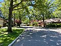
Duck Pond Drive in the Estates II subdivision, which is an example of a gated condominium development allowed under the 20th Century rezoning plans.
-
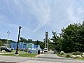
Christopher Morley Park on July 22, 2021.


See also
 In Spanish: North Hills (Nueva York) para niños
