
North Richmond, New South Wales facts for kids
Quick facts for kids North RichmondSydney, New South Wales |
|||||||||||||||
|---|---|---|---|---|---|---|---|---|---|---|---|---|---|---|---|

North Richmond
Location in New South Wales
|
|||||||||||||||
| Population | 4,977 (2016 census) | ||||||||||||||
| Postcode(s) | 2754 | ||||||||||||||
| Elevation | 27 m (89 ft) | ||||||||||||||
| Location |
|
||||||||||||||
| LGA(s) | Hawkesbury | ||||||||||||||
| State electorate(s) | Hawkesbury | ||||||||||||||
| Federal Division(s) | Macquarie | ||||||||||||||
|
|||||||||||||||
North Richmond is a semi-rural suburb of Richmond, in the state of New South Wales, Australia. North Richmond is located 67 kilometres north-west of the Sydney central business district in the local government area of the City of Hawkesbury. It is separated from Richmond to the south-east by the Hawkesbury River.
History
The traditional land owners of the town and surrounding district are the Darug people. In the early years of European Settlement, the area was known as Enfield. The name was changed at a later date during the 19th century to avoid confusion with Enfield in Sydney's west. While located to the west of the town of Richmond, it is thought to have been named North Richmond because it was north of Richmond Hill. This hill was named by Governor Philip when travelling up the Hawkesbury River in 1789.
In 1833 the "Woolpack Inn" was opened on higher ground near the river crossing, by John Town, a prominent local landowner. In 1874 the name changed to the "Travellers' Rest". In 1933 a more modern hotel was built next to the old inn and in 1940 was renamed the "North Richmond Hotel".
In the 1860s a wooden bridge was built across the Hawkesbury River to provide an easier crossing than the ferry or punt which had been used. In 1905 it was replaced by a higher level bridge which was the largest reinforced concrete bridge to be constructed. It remained so for 20 years. In 1926 a railway branch line between Richmond and Kurrajong was opened. The railway bridge was built right next to the concrete bridge. The line curved to the right at the western end of the bridge before curving back around to cross Bells Line of Road at an angle near the intersection with Grose Vale Road. North Richmond had a railway station. When the line closed in 1952 the railway bridge became part of the roadway.
Beside a hotel and school, North Richmond also had a Police Station and lockup and a Wesleyan (Methodist) Chapel.
Landmarks
North Richmond has three main roads. These are Grose Vale Road, Bells Line of Road and Terrace Road. North Richmond has a shopping mall consisting of a Coles supermarket and various shops including Dominos Pizza and Subway. There is the local primary school called Richmond North Public School and the high school, Colo High School. West of the town is the mountains and east is the Hawkesbury River. A Panthers Club is located in North Richmond. There are three main parks in North Richmond, John Wellington Oval, Turnbull Oval and Inalls Lane. Cricket is played at John Wellington Oval and Turnbull Oval. Soccer is played at Turnbull Oval and Inalls Lane. The Colo Cougars Soccer Club are based at Inalls Lane.
Images for kids
-
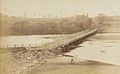
North Richmond bridge undergoing repairs, Sydney, ca. 1871

