
Nundah, Queensland facts for kids
Quick facts for kids NundahBrisbane, Queensland |
|||||||||||||||
|---|---|---|---|---|---|---|---|---|---|---|---|---|---|---|---|
 |
|||||||||||||||

Nundah
Location in Queensland
|
|||||||||||||||
| Population | 12,141 (2016 census) | ||||||||||||||
| • Density | 3,110/km2 (8,100/sq mi) | ||||||||||||||
| Postcode(s) | 4012 | ||||||||||||||
| Area | 3.9 km2 (1.5 sq mi) | ||||||||||||||
| Time zone | AEST (UTC+10:00) | ||||||||||||||
| Location | 8.9 km (6 mi) NNE of Brisbane GPO | ||||||||||||||
| LGA(s) | City of Brisbane (Hamilton Ward; Northgate Ward) |
||||||||||||||
| State electorate(s) | Nudgee | ||||||||||||||
| Federal Division(s) | Lilley | ||||||||||||||
|
|||||||||||||||
Nundah (previously called German Station) is an inner suburb in the City of Brisbane, Queensland, Australia. It contains the neighbourhood of Toombul. In the 2016 census, Nundah had a population of 12,141 people.
Prior to European settlement, Nundah was inhabited by Aboriginal people from the Turrbul tribe. Nundah is primarily a residential suburb, which straddles Sandgate Road, one of the major arterial roads of Brisbane's north. It was first settled by Europeans in the mid-19th century, although the suburb remained primarily a rural area until it was connected to Brisbane via railway in the 1880s. Originally considered a working-class suburb, the area has become gentrified in recent years, and today features a mix of traditional worker's cottages and modern high-density apartment blocks. It is close to the Centro Shopping Centre.
Contents
Geography
Nundah is a mixed-density residential suburb, with some light industry and a commercial retail area concentrated on Sandgate Road. It is adjacent to the suburbs of Clayfield, Northgate and Wavell Heights, and is dominated by a large ridge that runs from the northwest to the southeast. The "Nundah Village" shopping district and Nundah State School are on this ridge, while the George Bridges Tunnel bisects it along Sandgate Road.
The suburb includes the locality and formerly distinct suburb of Toombul, which is centred in the south of Nundah, around Sandgate Road. Various facilities in Nundah are named after this locality, including the large shopping centre Centro Toombul, Toombul Bus Station and the Toombul railway station.
Schulz Canal runs through Nundah, bisecting the Toombul Shopping Centre Carpark. The low elevation of the carpark makes it particularly susceptible to flash flooding during peak storm seasons – often claiming the cars of unwary shoppers inside the centre and those attempting to cross the Melton Road bridge. The estuary of the canal is a moderately popular recreational fishing spot.
History
Aboriginal history
Like most of Northern Brisbane, the area around Nundah was dominated by the Turrbul tribe. Their traditional coastal trade route passed through Nundah, near the modern-day Hedley Avenue. There are also many significant Aboriginal sites near Nundah, such as Dinah Island, which was reportedly the site of the last traditional Aboriginal burial in the Brisbane area. There were a number of bora rings in the area, indicating that the Nundah area was densely populated by Aboriginal people before European settlers arrived.
European settlement
German mission

The first permanent European settlement in the area was a mission built in 1838 by German Lutheran missionaries, under the guidance of Reverend Carl Wilhelm Schmidt and later Reverend Christoph Eipper with the aim of bringing Christianity to the local Aboriginal people. They first called the area "Zion", and the mission was located in the vicinity of the modern-day street "Walkers Way". It later became "German Station". The explorer Dr. Ludwig Leichhardt visited the area in 1843, and spoke very highly of the mission, but despite this the mission met with limited success and was closed at the behest of the colonial government in 1846. This first settlement is nonetheless commemorated with a monument at the corner of Sandgate Road and Wood Street unveiled in 1938 by the then Premier of Queensland William Forgan Smith. The names of these German settlers can be seen in the names of streets in Nundah and surrounding suburbs such as Rode Road and Gerler Road.
Growth of the village of German Station
A prominent local citizen who contributed significantly to the development of the village of German Station was George Bridges (1820–1898). George and his young family immigrated from Wilstead, Bedfordshire, England to Queensland in 1852 aboard the "Marie Somes". In 1855, he acquired 64 acres (26 ha) of land north of Buckland Road and east of Sandgate Road for farming. However, as Sandgate became an increasingly popular holiday destination, the increasing volume of coach traffic along Sandgate Road encouraged him to open a hotel, which became a popular stop being roughly halfway between Brisbane and Sandgate. The first hotel was called the Kedron Hotel but the third and longest-running hotel was known as the Kedron Brook Hotel and was located alongside Sandgate Road (now Bage St) on the SW corner of his property. Emboldened by the success of his hotel ventures, George Bridges looked for other commercial opportunities. He observed that Sandgate Road at that time did a dog-leg around the SW corner of his property (along Buckland Road) which forced traffic to travel up and over Donkin's Hill. So he created a short-cut across the SW corner of his property that avoided the hill, which was much appreciated by the travellers, allowing George Bridges to sell off parcels of land along this new unofficial piece of Sandgate Road to commercial enterprises, which serviced both the travellers and the local farming community. This unofficial short-cut grew into the Nundah Village shopping street that exists today and eventually became the official route of Sandgate Road. Around 1872, George and his wife Mary retired to Burpengary and began to progressively sell off the land of their German Station property as the village developed.
Creation of the suburb of Nundah
German Station remained an agricultural area until the 1880s. In 1881, Queensland State Government purchased a strip of land across George Bridges's property to build a railway link between Brisbane and Sandgate. The railway opened in 1882 and resulted in a suburban residential construction boom on Brisbane's northside. This urban sprawl was also encouraged by the Undue Subdivision of Land Prevention Act 1885, which mandated minimum lot sizes for new urban developments. The village of German Station became known as a location where working-class families could obtain cheap housing on reasonably sized lots not too far from the city. George Bridges sold off his remaining land for residential development in the new suburb.
A railway station called "German" was created in 1882 (again on land originally owned by George Bridges), because they wanted the station to be called "German Station" rather than "German Station Station". However, six weeks after the railway station opened, it was renamed "Nundah", derived from the Aboriginal name for the area. In 1888, the name of the Post Office was also changed to Nundah, signalling the renaming of the new suburb. However, the name "German Station" persisted for many years. For example, the German Station National School did not become Nundah State School until 1896. For many years it was common to find references to "Nundah" with the annotation "formerly German Station" in newspapers and advertisements, until the name "Nundah" was well established.
From 1890, Nundah was the seat of the Shire of Toombul, which was absorbed into the City of Greater Brisbane in 1925. The Toombul Shire Hall still exists as a community centre.
In 1909, Surrey Street in Nundah became the site of the first public housing dwelling in Queensland. In the early twentieth century, Nundah became a major suburban centre, due to its location on Sandgate Road, one of Brisbane's busiest arterial roads, and the adjacent Nundah railway station. Sandgate Road and nearby streets were lined with shops, pubs, cinemas and other commercial premises.
The Shire of Toombul War Memorial was dedicated by the Governor of Queensland, Matthew Nathan, on 12 November 1921. The memorial commemorates who served in World War I. It is located in Nundah Memorial Park (then known as Buckland Park) (27°24′10″S 153°03′31″E / 27.402890°S 153.058696°E).
In 1926, George Walker suggested a monument be built to mark the beginnings of Nundah, which was unveiled by the Queensland Governor Sir Leslie Orme Wilson on 23 April 1938 as part of the First Free Settlers' Centenary Celebrations. This First Free Settlers Monument is listed in the Queensland Heritage Register.
Decline of Nundah
Nundah's commercial precinct suffered a precipitous decline from the 1970s with the construction of the nearby Westfield Shoppingtown (Later Centro) Toombul shopping centre. Increasing motor traffic along Sandgate Road also reduced Nundah's appeal as a shopping precinct as it was difficult to park. Gradually many shops closed, and those that opened in their place were often "low-class" establishments such as pawn brokers, charity stores etc. that were unappealing to most shoppers, driving them increasingly to shop at Toombul.
Renewal of Nundah
However, in 2001 a road tunnel was constructed under nearby Bage Street, diverting through traffic away from the suburban centre. There was considerable popular support to name the road tunnel after George Bridges in recognition of his contribution to the development of the district and the fact that the tunnel was located on his original land holding. However, the local member Liddy Clark would not support it for fear it would offend the Aboriginal community. In 2009 as part of Queenslands 150th Birthday Celebrations, the Nundah Bypass Tunnel was renamed "George Bridges Tunnel".
In 2008 the Brisbane City Council suburban renewal programme has seen new art installations, cafés and commercial enterprises open in Nundah, creating a village-like atmosphere along the now-quiet Sandgate Road. The suburb has now become popular among white collar workers seeking relatively inexpensive housing and apartments only a moderate distance from the Brisbane CBD. Since then, along with the rest of the city, housing prices in the area have skyrocketed, pricing most of the traditional working class out of the suburb.
Heritage listings
.jpg)

Nundah has a number of heritage-listed sites, including:
- 136 Buckland Road: Corpus Christi Church
- 88 Hedley Avenue: Nundah Cemetery
- Sandgate Road: First Free Settlers Monument
- Sandgate Road: Nundah Air Raid Shelter
- 1141 Sandgate Road: Toombul Shire Hall
- 35 Surrey Street: Workers' Dwelling No.1
- 7 Union Street: Nundah Fire Station
Demographics
In the 2016 census the population of Nundah was 12,141, 50.5% female and 49.5% male. The median age of the Nundah population was 33 years of age, 5 years below the Australian median. 63.1% of people living in Nundah were born in Australia, compared to the national average of 66.7%; the next most common countries of birth were India 5.9%, New Zealand 4.5%, England 3.2%, Philippines 1.4% and Nepal 1.3%. 72.7% of people spoke only English at home; the next most common languages were Punjabi 2.2%, Hindi 1.6%, Nepali 1.3%, Mandarin 1.3% and Spanish 1.0%.
Transport
Due to its inner-northern location, there are a variety of options for transport within the suburb. Both Nundah railway station and Toombul railway station are located within the suburb. Both of these railway stations are on both the North Coast line and are served by Caboolture and Shorncliffe line services, giving both stations 15-minute frequencies throughout the day seven days a week. There are many council bus services that run through the area, including the Great Circle Line.
The Nundah Bypass is a 285-metre-long (935 ft) road tunnel, open to general traffic, that runs underneath the Nundah Village commercial area. Completed in 2001, it provides an alternative route to traffic travelling along Sandgate Road, allowing motorists to avoid the narrow streets of the village area, and reducing traffic congestion for local residents.
Toombul District Cricket Club
The Toombul District Cricket Club is directly across Duke Street from Nundah Train Station. It covers 3.5 hectares, and is bordered by York Street, Duke Street, Melton Road and Jenner Street. The club was founded in 1882, and has been based at Oxenham Park in the heart of Nundah since 1912.
The cricket club provides a family friendly, relaxed atmosphere for local residents to take in a match on Saturdays and Sundays during summer, and enhances the village feel of Nundah by being an exceptionally welcoming club, with full bar and canteen facilities open to locals. In November 2016, Toombul began renovations to the clubhouse including a rooftop bar, in line with the gentrification and development of Nundah.
Famous players that have played for Toombul at Oxenham Park over the years include three of Don Bradman's 1948 Invincibles; Bill Brown (cricketer), Don Tallon, and Colin McCool. Others include Jeff Thomson, Ken Mackay, Ron Oxenham, Ryan Harris, Chris Lynn and Wally Grout.
Landmarks

- Bage Street, named after Freda Bage, first principal of The Women's College, University of Queensland
- Bishop Park – home ground of the Norths Devils rugby league team in the Queensland Cup competition
- Boyd Park – grounds used by the Nundah State School
- Oxenham Park – home of the Toombul District Cricket Club in the Queensland Cricket Association Grade competition, and contains the Ken MacKay and LaFrantz Ovals
- Centro Toombul Shopping Centre
- Nundah Criterium Bicycle Track – in Hedley Avenue/Walkers Way Nundah, next to Albert Bishop Park and the Schultz Canal bikeway
- Nundah Catholic Church
- Nundah Historic Cemetery – contains the graves of many of the original settlers and their families
- Nundah Library – adjacent to the Sir William Knox Archives & Resource Centre
- Nundah State School – established 1865 as German Station National School
- Nundah Shopping Village
- Nundah Railway Station
- Prince of Wales Hotel
- Ross Park Skate and BMX Park
- Royal English Hotel
- Schulz Canal
- Sir William Knox Archives & Resource Centre – behind the Nundah State Library.
- Toombul Railway Station
- Toombul Shire Hall
- Tufnell Home Orphanage – Now the Tufnell Child Care Centre
Parks

- Albert Bishop Park – Amelia Street, Hedley Avenue and Nudgee Road, adjoining Schulz Canal
- Boyd Park – Bage Street and Boyd, Park and Sandgate Roads
- Carew Street – Brook and Carew Streets
- Kalinga Park – Jackson and Kalinga Streets, Park Avenue and Sandgate Road, adjoining Schulz Canal
- Nundah Memorial Park (formerly Buckland Park) – Buckland Road and Bage Street
- Oxenham Park – Duke, Jenner and York Streets and Melton Road
- Plaisted Place – Cavendish, Flower and Maynard Streets
- Ross Park – Parkland Street and Sandgate Road, adjoining Schulz Canal

- Toombul Terrace – Bage, Gardner and Glenhill Streets, Hamson and Toombul Terraces and Royal Avenue
- Upton Street – Upton Street, off London Street
- Wood Street (Road Reserve) – Bage and Wood Streets and Sandgate Road
Community services
- Nundah Combined St John Ambulance Division
- Nundah-Northgate Scout Group (Scouts Australia) celebrating centenary in 2009
Education
Nundah State School is a government primary (Prep-6) school for boys and girls at 41 Bage Street (27°24′09″S 153°03′30″E / 27.4025°S 153.0583°E). In 2017, the school had an enrolment of 714 students with 48 teachers (42 full-time equivalent) and 25 non-teaching staff (14 full-time equivalent). It includes a special education program.
Northgate State School is a government primary (Prep-6) school for boys and girls at 128 Amelia Street (27°23′55″S 153°04′15″E / 27.3987°S 153.0708°E) in eastern Nundah. In 2018, the school had an enrolment of 291 students with 26 teachers (18 full-time equivalent) and 15 non-teaching staff (9 full-time equivalent).
St Joseph's School is a Catholic primary (Prep-6) school for boys and girls at 16 Leslie Street (27°24′14″S 153°03′24″E / 27.4038°S 153.0568°E). In 2017, the school had an enrolment of 190 students with 20 teachers (13 full-time equivalent) and 13 non-teaching staff (6 full-time equivalent).
Mary MacKillop College is a Catholic secondary (7-12) school for girls at 60 Bage Street (27°24′14″S 153°03′30″E / 27.4038°S 153.0584°E). In 2017, the school had an enrolment of 524 students with 40 teachers (39 full-time equivalent) and 18 non-teaching staff (15 full-time equivalent). It was formerly known as Corpus Christi College.
There is no government secondary school in Nundah. The nearest government secondary schools are Aviation High in Hendra and Wavell State High School in Wavell Heights.
Help Employment & Training at 1176 Sandgate Road provides training for people with disabilities and assists with finding jobs.
Notable residents
- George Bridges, (1820–1898) pioneer farmer and developer after whom the tunnel was named
- Thomas Bridges (1853–1939) son of George Bridges, Member of the Legislative Assembly
- Bob Bax, legendary coach of The Norths Brisbane first grade rugby league team which is based out of Bishop Park, Nundah and formerly Oxenham Park, Nundah. Bax coached the club to five of their historical six successive premiership victories between 1959 and 1964.
- Elizabeth Grace OAM (born 27 May 1940).OAM Citation: For service to the community of Nundah.
- Bill Knox (1927–2001) Member of the Legislative Assembly, Treasurer of Queensland
- Errold La Frantz MBE (25 May 1919 – 20 February 2015). Oval 2 at Oxenahm Park is named La Frantz Oval in honour of Errold.
- Ken 'Slasher' Mackay Australian test cricketer
- Irene Sweeney (Local Identity), Fanatical supporter of both Nundah-based sports clubs; Toombul District Cricket Club, and Norths Devils Rugby League Club.
- Meta Truscott Australian diarist
An index to people mentioned in the book From Pioneering Days: Nundah Northgate Virginia by Nundah & Districts Historical Society Inc can be found here. While many of the people listed are residents of the district, some people may have had only a peripheral involvement with it.
Images for kids
-
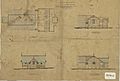
Architectural plans for school and teachers residences at German Station, circa 1880
-
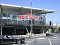
Nundah Village shopping centre


