O'Brien County, Iowa facts for kids
Quick facts for kids
O'Brien County
|
|
|---|---|

|
|

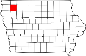
Location within the U.S. state of Iowa
|
|
 Iowa's location within the U.S. |
|
| Country | |
| State | |
| Founded | 15 January 1851 |
| Named for | William Smith O'Brien |
| Seat | Primghar |
| Largest city | Sheldon |
| Area | |
| • Total | 573 sq mi (1,480 km2) |
| • Land | 573 sq mi (1,480 km2) |
| • Water | 0.2 sq mi (0.5 km2) 0.03% |
| Population
(2020)
|
|
| • Total | 14,182 |
| • Density | 24.750/sq mi (9.556/km2) |
| Time zone | UTC−6 (Central) |
| • Summer (DST) | UTC−5 (CDT) |
| Congressional district | 4th |
O'Brien County is a county in the U.S. state of Iowa. As of the 2020 United States Census, the population was 14,182. The county seat is Primghar.
Contents
History
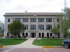
O'Brien County was founded in 1851. The county was named for William Smith O'Brien, a leader for Irish independence in 1848. The present courthouse was completed in 1917, and is listed on the National Register of Historic Places.
Geography
According to the U.S. Census Bureau, the county has a total area of 573 square miles (1,480 km2), of which 573 square miles (1,480 km2) is land and 0.2 square miles (0.52 km2) (0.03%) is water.
Major highways
 U.S. Highway 18
 U.S. Highway 59
 Iowa Highway 10
 Iowa State Highway 60
 Iowa Highway 144
Adjacent counties
- Osceola County (north)
- Clay County (east)
- Cherokee County (south)
- Sioux County (west)
Demographics
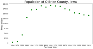
| Historical population | |||
|---|---|---|---|
| Census | Pop. | %± | |
| 1860 | 383 | — | |
| 1870 | 715 | 86.7% | |
| 1880 | 4,155 | 481.1% | |
| 1890 | 13,060 | 214.3% | |
| 1900 | 16,985 | 30.1% | |
| 1910 | 17,262 | 1.6% | |
| 1920 | 19,051 | 10.4% | |
| 1930 | 18,409 | −3.4% | |
| 1940 | 19,293 | 4.8% | |
| 1950 | 18,970 | −1.7% | |
| 1960 | 18,840 | −0.7% | |
| 1970 | 17,522 | −7.0% | |
| 1980 | 16,972 | −3.1% | |
| 1990 | 15,444 | −9.0% | |
| 2000 | 15,102 | −2.2% | |
| 2010 | 14,398 | −4.7% | |
| 2020 | 14,182 | −1.5% | |
| US Decennial Census 1790-1960 1900-1990 1990-2000 2010-2018 |
|||
2020 census
The 2020 census recorded a population of 14,182 in the county, with a population density of 24.8184/sq mi (9.5824/km2). 95.42% of the population reported being of one race. 83.49% were non-Hispanic White, 1.14% were Black, 6.95% were Hispanic, 0.56% were Native American, 0.56% were Asian, 0.08% were Native Hawaiian or Pacific Islander and 7.23% were some other race or more than one race. There were 6,524 housing units, of which 5,861 were occupied.
2010 census
As of the 2010 United States Census, there were 14,398 people, 6,069 households, and 3,927 families in the county. The population density was 25.1239/sq mi (9.7004/km2). There were 6,649 housing units at an average density of 11 per square mile (4/km2). The racial makeup of the county was 96.0% White, 0.5% Black or African American, 0.1% American Indian, 0.6% Asian, 2.0% from other races, and 0.8% from two or more races. The county has a 3.8% Hispanic or Latino background.
There were 6,069 households, out of which 26.0% had children under the age of 18 living with them, 55.1% were married couples living together, 6.1% had a female householder with no husband present, 3.5% had a male householder with no wife present, and 35.3% were non-families. 31.5% of all households were made up of individuals living alone, and 33.1% had someone living alone who was 65 years of age or older. The average household size was 2.31 and the average family size was 2.89.
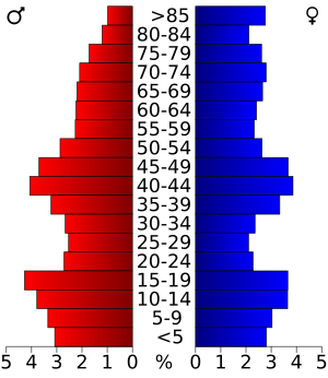
The county population contained 25.7% under the age of 20, 4.6% from 20 to 24, 21.3% from 25 to 44, 28.1% from 45 to 64, and 20.4% who were 65 years of age or older. The median age was 43.6 years. For every 100 females there were 95.80 males. For every 100 females, there were 99.1 males.
The median income for a household in the county was $44,018, and the median income for a family was $58,127. The per capita income for the county was $24,771. About 6.3% of families and 11.0% of the population were below the poverty line, including 15.7% of those under age 18 and 8.3% of those age 65 or over.
Communities
Cities
Unincorporated communities
Townships
- Baker Township
- Caledonia Township
- Carroll Township
- Center Township
- Dale Township
- Floyd Township
- Franklin Township
- Grant Township
- Hartley Township
- Highland Township
- Liberty Township
- Lincoln Township
- Omega Township
- Summit Township
- Union Township
- Waterman Township
Population ranking
The population ranking of the following table is based on the 2010 census of O'Brien County.
† county seat
| Rank | City/Town/etc. | Municipal type | Population (2010 Census) |
|---|---|---|---|
| 1 | Sheldon (partially in Sioux County) | City | 5,188 |
| 2 | Hartley | City | 1,672 |
| 3 | Sanborn | City | 1,404 |
| 4 | Paullina | City | 1,056 |
| 5 | † Primghar | City | 909 |
| 6 | Sutherland | City | 649 |
| 7 | Calumet | City | 170 |
| 8 | Archer | City | 131 |
See also
 In Spanish: Condado de O'Brien para niños


