
Oaxaca facts for kids
Quick facts for kids
State of Oaxaca
|
|||
|---|---|---|---|
|
|||

Location within Mexico
|
|||

Municipalities of Oaxaca
|
|||
| Country | |||
| Capital | Oaxaca | ||
| Municipalities | 570 | ||
| Area | |||
| • Total | 93,952 km2 (36,275 sq mi) | ||
| Population
(2005)
|
|||
| • Total | 3,506,821 (Ranked 10th) | ||
| • Density | 37/km2 (100/sq mi) | ||
| Time zone | UTC-6 (CST) | ||
| • Summer (DST) | UTC-5 (CDT) | ||
| HDI (2004) | 0.7164 - medium Ranked 31st |
||
| ISO 3166-2 | MX-OAX | ||
| Postal abbr. | Oax. | ||


Oaxaca is a state in Mexico. The capital is Oaxaca de Juárez. Oaxaca is next to Guerrero, Puebla, Veracruz, and Chiapas. About 3.5 million people live there. The Zapotec and the Mixtec people live in the state. There are more speakers of indigenous languages in this state than in any other state of Mexico.
Contents
History
Pre-Columbian


Oaxaca's rugged terrain caused various groups to develop in relative isolation from one another, and therefore the cultural and linguistic diversity of the region. The central Valley of Oaxaca was one of the most fertile areas of the Americas and allowed powerful and influential groups to emerge. The valley was first occupied by the Zapotec people, who were conquered by the Mixtecs in the 13th century. Society was mainly organized in villages by extended family groups with communal authority, although the civilizations of the Mixtecs and Zapotecs did have kings and religious orders.
The accomplishments of these civilizations included the domestication of many plants and animals including maize, beans, cacao, tomatoes, chili peppers, squash, pumpkin, and turkeys. Also available in the fertile region of Oaxaca were pineapples, avocados, zapotes, and maguey. In the south, the Pacific Ocean was an important food source. The civilizations built by these groups are reflected in important archaeological sites including Monte Albán, Mitla, Guiengola and Huijatzoo. Monte Albán was a great ceremonial center built on a flattened mountain top by the Zapotec people which reached its zenith between 600 and 900 AD. The ancient Zapotec village of Teotitlán del Valle, near the city of Oaxaca, is one of the oldest human settlements in Mexico.
Throughout the Zapoteca era, the local and regional trade flourished, and most important economic activities were agriculture, hunting, fishing and mining; silver and gold were fashioned by artisans for hundreds of years. Commercial routes passed through Oaxaca to the Mayan lands of the north and south to Central and South America. Major ports were located in present-day Salina Cruz, Astata, Huatulco, Puerto Ángel and Pinotepa Nacional.
In the mid-15th century, the central valley was conquered by the Aztecs, who forced the surrounding Mixtec and Zapotec kingdoms to pay tribute to the emperor in the Aztec capital, Tenochtitlan. The Aztec presence increased the social and economic ties between Oaxaca and the Aztec heartland. Shortly after 1496, the Aztecs established a garrison in the center of the valley, around the Cerro del Fortín and down to the present Church of Carmen Alto where their temple was located. The Aztecs called their garrison Huāxyacac, meaning "place of guaje (Leucaena esculenta) trees" in the Nahuatl language. Under Spanish rule, Huāxyacac became Oaxaca, and the pronunciation of the x transitioned from "sh" to the modern Mexican Spanish "j".
Colonial period
Tenochtitlan fell to the Spanish in August of 1521 and with it all of the Aztec empire. The Spanish crown granted Oaxaca to the conquistador Hernan Cortes as his prize for conquering New Spain. On November 25, 1521, Francisco de Orozco arrived in the central valley to claim it in the name of Cortes. Cortes was thereby named Marques del Valle de Oaxaca. The same year, the Spanish founded a settlement named Segura de la Frontera, later known as Nueva Antequera, and in 1532 it was officially raised to the category of a royal city by decree of Emperor Charles V (Carlos I) with the name of Antequera de Guaxaca.
Transformation was swift in the central valley; the Spanish introduced new food and new methods of cultivation. Cortes ordered the cultivation of wheat in the Valley of Etla and the construction of mills. The Spanish cultivated sugar cane and imported silkworms. Diseases introduced by the Spanish greatly diminished the native population of Oaxaca, as did the insatiable appetite for gold, which led more and more Oaxacans into the dangerous mines.
Over the 300 years of colonialism, many aspects of life became Europeanized. Important government positions were filled by the Spanish and their descendants, and later by elite mestizos, persons of mixed European and indigenous ancestry.
Mexican War of Independence (1821)
Mexico won independence from Spain in 1821. Throughout the 1800s and into the early 1900s, Oaxaca remained largely an agriculture-based economy with little new industry. The automobile created a divide between the traditional villages and the new urban world of mobility and fast communication. A railroad was built connecting Oaxaca to Mexico City.
Mexican Revolution (1910) and afterward

When the Mexican Revolution began in 1910, Oaxaca, like many southern states, rallied around the revolutionary Emiliano Zapata who proclaimed that the land belonged to the workers. This rhetoric resonated with Oaxacans, since many of them were being exploited by the large landowners. After Díaz was removed from power, dissension among the revolutionary leaders continued to divide the people of Mexico. With President Venustiano Carranza eventually coming into power, the relationship between Oaxaca and the federal government deteriorated. Oaxacans disliked the new president so much that Carranza’s brother was assassinated in Oaxaca. The period from 1916 to 1920 was filled with constant struggle for control of the new government; in the end, federal troops won out.
After the revolution, Oaxaca received little attention from the national government, resulting in virtually no industrialization and minimal economic growth. The state benefited little from Mexico's rapid economic growth after World War II (1939–1945). By the 1980s and 1990s, Oaxaca was one of Mexico's poorest states, having some of the nation's highest rates of illiteracy, malnutrition, and infant mortality, especially among its Native American population.
Capitalism in the late 20th century and its environmental impact
Oaxaca is one of Mexico’s prime regions for growing shade coffee. More than three-quarters of Mexico’s coffee is grown on small plots shaded by the existing forest. Because they preserve forest cover, shade coffee farms provide vital ecological services including harboring biodiversity and preventing soil erosion. Unfortunately, tree cover in Mexico’s shade coffee areas is increasingly being cleared to make way for subsistence agriculture, a direct result of the unprecedented decline of international coffee prices over the past decade.
This deforestation remains a large problem, because it is often viewed as a sign of progress. It is also a means for the poorest segment of Mexico's rural population to gain unclaimed land. Fifty percent of Mexican farmers now live at subsistence levels. Either they move further into the forests, thereby increasing deforestation, or migrate to the cities. Centuries of deforestation have resulted in rampant erosion, forcing migration to the cities and the U.S.
Geography

Oaxaca is located at the convergence of the Sierra Madre Oriental and the Sierra Madre del Sur mountain ranges, resulting in a rugged and mountainous terrain with a large temperate central valley. The average altitude is 1,500 meters (5,085 feet) above sea level. The area is a distinct physiographic section of the larger Sierra Madre del Sur province.
On February 12, 2008, a 6.4 magnitude earthquake was recorded in Oaxaca.
Demography

Oaxaca has a high concentration of indigenous people. There are 16 formally registered indigenous communities, some of which are culturally diverse themselves. The 16 groups and the number of speakers of their language according to the 2005 census are:
|
Of these, 477,788 are non-Spanish monolingual.
Most of the indigenous languages belong to the Oto-Manguean family, while Mixe, Zoque, and Popoloco belong to the Mixe-Zoque family, and Huave is a language isolate, while Oaxacan Chontal is thought to be Hokan.
85% of the population declares to follow the Catholic faith.
Education

The limited educational background suffered by the state is due to the dispersion of the population, and current statistics show that the average schooling lies very low at 6.4 years, barely equivalent to primary education.
Institutions of higher education include:
- Instituto Tencológico de Oaxaca (ITO)
- Universidad Autónoma Benito Juárez de Oaxaca (UABJO)
- Universidad de la Sierra Juárez (USJ)
Industry and infrastructure

Oaxaca's principal industry is tourism, with over Template:Km to mi of beaches, colonial architecture, archaeological treasures, crafts and folk art. The prominent colonial destination is the city of Oaxaca which contains the Santo Domingo Temple, the Government Palace, the Macedonio Alcala Theater, the Rufino Tamayo Museum of Prehispanic Art, and the House of Cortés.
The dominant archaeological destination is Monte Alban, the capital of the ancient Mixtec-Zapotec empire. Mitla, originally meaning "place of the dead" in Zapotec, is known for its unique ancient tile work.
Agriculture in the state is mainly focused in the production of the type of agave used for the popular alcoholic drink of Mezcal, since the name of Oaxaca is closely linked to the original drink as a brand. Other products reporting important volumes nationwide include black bean and mango, followed by green pepper, sour lemon, sugar cane, peanut, melon, corn grain and coffee. The fishing industry is based mainly in the capture of red-snapper and dogfish, while the mining sector extracts sulfur.
Transport
Transportation is provided by many secondary roads and highways, and a toll-road that leads to Mexico City through Puebla and another that will lead from Oaxaca City to Huatulco. Major airports include Oaxaca City's Xoxocotlán International Airport, as well as smaller airports in Huatulco and Puerto Escondido. The airports are served by a number of local and regional carriers, such as Aeroméxico, Aerocaribe, Aerotucan, Aviacsa, Mexicana, and Continental.
Law and government

The state of Oaxaca is divided into municipalities (Spanish: municipios), 571 in all—more than any other Mexican state, and accounting for almost 1/4 of all the municipios in the country. Each municipality is headed by a municipal president (mayor).
The municipalities are grouped into 8 regions: Cañada, Costa, Istmo, Juchitan, Papaloapan, Sierra Norte, Sierra Sur, and Valles Centrales.
The reason why there are so many municipalities is the state's large size and rough terrain, which causes indigenous communities tend to identify strongly with their village rather than their region.
Many towns and villages are self-ruled by a system called Usos y Costumbres which advocates retention of culture and practical ways of doing daily business. It is argued that this autonomy protects the land of indigenous people. However, the system leads to plurality for individual villages or towns, and the ideologies of these villages tend to depart from each other, encouraging regional and tribal rivalries. Regions compete for autonomy, and differences in ideology (primarily within culture) and end up forming another municipality. Also, since Usos y Costumbres advocates autonomy, it fails to identify with the village's head of government, so there is no direct communication between the state and villages. A failure to adapt quickly for political change leaves the villages and towns vulnerable to exploitation by interest groups and big government, who do not see an incentive in aligning their policies with the views of such towns.
Culture
Festivals
Major festivals include the día de los muertos ("day of the dead") and noche de los rabanos ("night of the radishes"). In Zapotec villages, families traditionally finance the large communally organized dances and feasts on patron saints' days through a system of making small loans over many years and then calling them in on an occasion when the family has volunteered to be the festival sponsor or mayordomo; this economic system is known in Zapotec as guelaguetza. This practice has given its name to the largest festival of dance and music in the state, the Guelaguetza, a major attraction for regional, national, and international tourists that is put on annually at a stadium built for the purpose overlooking the city of Oaxaca.
Crafts

Oaxaca has a number of native crafts, including the production of alebrijes, weaving and black clay objects. Alebrijes are popular wooden figurines of mythical beings, animals, and fantastic combinations of both, usually painted with very vibrant colors. While many communities in Oaxaca will define themselves according to their crafts, many of these communities only entered production recently and as a way to access tourism. Unfortunately, the economies of craft producing communities is largely dependent on tourist interests, tastes and desires. Since about 2000 demand for most crafts has been weak. Following the civil unrest of 2006/07 and the general collapse of tourism, demand for some crafts has nearly disappeared. Basket makers in at least one village have given up their craft, weavers complain of no market and a lack of access to export markets and alebrijes have lost much of their appeal as the market has changed (work by Michael Chibnik, Jeffrey Cohen, William Warner Wood and Lynn Stephen documents these shifts).
Zapotec weaving traditions were studied at length by Edwin Scheier and Mary Goldsmith in the 1960s.
Cuisine

For the same reasons its people are so diverse, Oaxaca boasts a tremendous diversity of regional cuisine, nicknamed "Land of the Seven Moles". An abundance of fruits and vegetables are grown in the central valley, tropical fruits are found in the north and fish and shellfish dominate the cuisine of the south. Oaxaca is also known for Oaxaca cheese (quesillo) which is now exported around the world and even made in many locations in the United States.
Corn tortillas are the staple food but a vast array of foods are prepared from corn dough, from entomatadas and empanadas to tamales and tlayudas. Black beans are also a common ingredient, as is the pasilla chile which gives many dishes their distinct hot, smoky taste and red color.
A breakfast specialty, generally only available in Oaxaca, is huevos oaxaqueños - eggs poached in a chili-tomato soup. Another specialty is chapulines, or roasted grasshoppers, a popular dish in the state's central valleys region. Chapulines are eaten after the rains begin and through early autumn.
Oaxaca is well-known for producing mezcal, a liquor somewhat similar to tequila. Like tequila, it derives from fermented agave fruit, but differs in taste and its tradition of family artisan production. The state is also famous for its chocolate, which is made from ground cacao beans, and often includes almonds, cinnamon and many other ingredients.
Shamanism
Oaxaca is known for at least one plant and one fungus, native to this area of the world, which are both used in shamanism: Psilocybe mushrooms and Salvia divinorum. The most notable shaman from this region is María Sabina of the Mazatec people. Álvaro Estrada, a fellow Mazatec, recorded her life and work and translated her chants. It is rumored, without validation, that many important 1960s celebrities visited Sabina, including rock stars such as Bob Dylan and John Lennon.
Images for kids
-
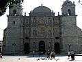
Cathedral of Our Lady of the Assumption, the motherchurch of the Oaxacan Archdiocese
-
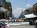
Protesters in Oaxaca, 2006
-
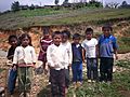
Mazateco children
-

Wax mannequin of woman in Mixtec dress
-

Popoloca woman
-

The conserved rainforest of Santiago Comaltepec, Oaxaca
-
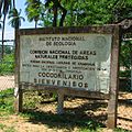
Entrance to the crocodile nursery located inside the Lagunas de Chacahua National Park
-
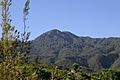
Cerro de San Felipe, Benito Juárez National Park
-
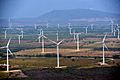
The Central Eólica Sureste I, Fase II in Asunción Ixtaltepec. The Isthmus of Tehuantepec is the region of Mexico with the highest capacity for wind energy.
-
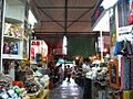
Benito Juárez Market, Oaxaca
-
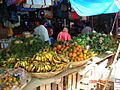
A market in Oaxaca
-

Xoxocotlán International Airport.
-
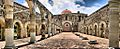
Ex-monastery of Santiago Apóstol in Cuilapan de Guerrero
-

View of Zipolite Beach
-
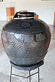
Barro negro pottery at the state crafts museum
-
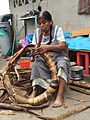
Craftswoman making banana leaf bun in Tavehua, Oaxaca.
-
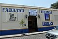
UABJO School of Languages.


.jpg)


See also
 In Spanish: Oaxaca para niños
