
Ogemaw County, Michigan facts for kids
Quick facts for kids
Ogemaw County
|
|
|---|---|
.jpg)
Ogemaw County Building in West Branch
|
|

Location within the U.S. state of Michigan
|
|
 Michigan's location within the U.S. |
|
| Country | |
| State | |
| Founded | G, 1840 (authorized) 1875 (organized) |
| Seat | West Branch |
| Largest city | Skidway Lake West Branch (incorporated) |
| Area | |
| • Total | 575 sq mi (1,490 km2) |
| • Land | 563 sq mi (1,460 km2) |
| • Water | 11 sq mi (30 km2) 2.0%% |
| Population
(2020)
|
|
| • Total | 20,770 |
| • Density | 39/sq mi (15/km2) |
| Time zone | UTC−5 (Eastern) |
| • Summer (DST) | UTC−4 (EDT) |
| Congressional district | 4th |
Ogemaw County ( oh-GUH-maw) is a county located in the U.S. state of Michigan. As of the 2020 Census, the population was 20,770. The county seat is West Branch.
The county newspaper of record is the Ogemaw Herald.
Contents
History
The county was originally created in 1840, but was absorbed into Iosco County in 1867. It was later recreated in 1873 and finally organized in 1875. The county's name is an Anglicization of the Anishinaabemowin word ogimaa, meaning "chief".
Geography
According to the U.S. Census Bureau, the county has a total area of 575 square miles (1,490 km2), of which 563 square miles (1,460 km2) is land and 11 square miles (28 km2) (2.0%) is water. Ogemaw County is considered to be part of Northern Michigan
Highways
 I-75
I-75 BL I-75
 M-30
M-30 M-33
M-33 M-55
M-55 F-18
F-18- F-28
Adjacent counties
- Oscoda County - north
- Alcona County - northeast
- Iosco County - east
- Arenac County - southeast
- Gladwin County - southwest
- Roscommon County - west
- Crawford County - northwest
National protected area
- Huron National Forest (part)
State protected area
- Au Sable State Forest (part)
- Rifle River State Recreation Area
Demographics
| Historical population | |||
|---|---|---|---|
| Census | Pop. | %± | |
| 1870 | 12 | — | |
| 1880 | 1,914 | 15,850.0% | |
| 1890 | 5,583 | 191.7% | |
| 1900 | 7,765 | 39.1% | |
| 1910 | 8,907 | 14.7% | |
| 1920 | 7,786 | −12.6% | |
| 1930 | 6,595 | −15.3% | |
| 1940 | 8,720 | 32.2% | |
| 1950 | 9,345 | 7.2% | |
| 1960 | 9,680 | 3.6% | |
| 1970 | 11,903 | 23.0% | |
| 1980 | 16,436 | 38.1% | |
| 1990 | 18,681 | 13.7% | |
| 2000 | 21,645 | 15.9% | |
| 2010 | 21,699 | 0.2% | |
| 2020 | 20,770 | −4.3% | |
| US Decennial Census 1790-1960 1900-1990 1990-2000 2010-2018 |
|||
As of the 2000 United States Census, there were 21,645 people, 8,842 households, and 6,189 families residing in the county. The population density was 38 people per square mile (15/km2). There were 15,404 housing units at an average density of 27 per square mile (11/km2). The racial makeup of the county was 97.48% White, 0.13% Black or African American, 0.60% Native American, 0.38% Asian, 0.03% Pacific Islander, 0.13% from other races, and 1.25% from two or more races. 1.16% of the population were Hispanic or Latino of any race. 28.7% were of German, 12.3% American, 10.2% English, 9.2% Irish, 7.0% French and 6.7% Polish ancestry. 97.9% spoke only English at home.
There were 8,842 households, out of which 27.10% had children under the age of 18 living with them, 57.40% were married couples living together, 8.80% had a female householder with no husband present, and 30.00% were non-families. 25.70% of all households were made up of individuals, and 12.20% had someone living alone who was 65 years of age or older. The average household size was 2.41 and the average family size was 2.87.
The county population contained 23.50% under the age of 18, 6.40% from 18 to 24, 24.40% from 25 to 44, 27.00% from 45 to 64, and 18.80% who were 65 years of age or older. The median age was 42 years. For every 100 females there were 98.40 males. For every 100 females age 18 and over, there were 95.50 males.
The median income for a household in the county was $30,474, and the median income for a family was $34,988. Males had a median income of $31,003 versus $20,544 for females. The per capita income for the county was $15,768. About 11.00% of families and 14.00% of the population were below the poverty line, including 18.50% of those under age 18 and 9.90% of those age 65 or over.
Communities
Cities
- Rose City
- West Branch (county seat)
Village
Census-designated places
- Lupton
- Skidway Lake
Townships
- Churchill Township
- Cumming Township
- Edwards Township
- Foster Township
- Goodar Township
- Hill Township
- Horton Township
- Klacking Township
- Logan Township
- Mills Township
- Ogemaw Township
- Richland Township
- Rose Township
- West Branch Township
Images for kids
-
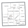
U.S. Census data map showing local municipal boundaries within Ogemaw County. Shaded areas represent incorporated cities.

See also
 In Spanish: Condado de Ogemaw para niños
