
Okinawa Prefecture facts for kids
Quick facts for kids Okinawa Prefecture |
|||||||||
|
|||||||||
 |
|||||||||
| Capital | Naha | ||||||||
| Region | Kyūshū | ||||||||
| Island | Okinawa | ||||||||
| Governor | Hirokazu Nakaima | ||||||||
| Area (rank) | 2,271.30 km² (44th) | ||||||||
| - % water | 0.5% | ||||||||
| Population (December 1, 2008) | |||||||||
| - Population | 1,379,338 (32nd) | ||||||||
| - Density | 606 /km² | ||||||||
| Districts | 5 | ||||||||
| Municipalities | 41 | ||||||||
| ISO 3166-2 | JP-47 | ||||||||
| Website | {{{Website}}} | ||||||||
| Prefectural Symbols | |||||||||
| - Flower | Deigo (Erythrina variegata) | ||||||||
| - Tree | Pinus luchuensis (ryūkyūmatsu) | ||||||||
| - Bird | Okinawa woodpecker (Sapheopipo noguchii) | ||||||||
| - Fish | Banana Fish (Caesio diagramma,"Takasago", "Gurukun") | ||||||||
 Symbol of Okinawa Prefecture |
|||||||||
Okinawa Prefecture (沖縄県, Okinawa-ken, Okinawan: Uchinaa-ken) is traditionally a prefecture in the Kyūshū region of Japan. Okinawa Prefecture is made up of islands which are southwest of the island of Kyushu. Recent government proposals recognize the prefecture as its own region.
The capital city is Naha which is on the island of Okinawa.
Contents
History
Timeline
- 1429: Shō Hashi founded the Ryūkyū Kingdom
- 1609: Shimazu of Satsuma Province invade Ryukyu Kingdom
- 1853: Commodore Mathew Perry and US Navy ships at Naha
- 1875 (Meiji 5): Ryūkyū Domain is created
- 1879 (Meiji 12): Okinawa Prefecture was established.
- 1945 (Shōwa 20): US administration after World War II
- 1953 (Shōwa 28): Partial reversion to Japan
- 1972 (Shōwa 47): Reversion to Japan
- 2000 (Heisei 12): 26th G8 summit at Kyushu and Okinawa
Geography
Okinawa is a grouping of many islands along the border at the edge of the East China Sea and the Pacific Ocean from Kyūshū to Taiwan. It is the southernmost prefecture in Japan.
Cities
Okinawa Prefecture has eleven cities. Okinawan names are in parentheses.
- Ginowan (Jinoon)
- Ishigaki (Ishigachi)
- Itoman (Ichuman)
- Miyakojima (Naaku)
- Nago (Nagu)
- Naha (Naafa) (capital)
- Nanjō (Nanjoo)
- Okinawa (Uchinaa) (formerly Koza)
- Tomigusuku (Timigushiku)
- Urasoe (Urashii)
- Uruma (Uruma)
Towns and villages
These are the towns and villages in each district.
|
|
|
National Parks
National Parks are established in about 19% of the total land area of the prefecture.
Shrines and Temples
Naminouegū was the chief Shinto shrine (ichinomiya) of the Ryukyu Islands. In 1890, the shrine was recognized in the system of State Shinto. It is among the ranked, nationally significant shrines or Kanpei-shōsha (官幣小社) which includes five sanctuaries.
Related pages
More reading
- Kerr, George H. (1958). Okinawa: the History of an Island People. Rutland, Vermont: Charles Tuttle Co. OCLC 722356
- ___________. (1953). Ryukyu Kingdom and Province before 1945. Washington, D.C.: National Academy of Sciences, National Research Council. OCLC 5455582
Images for kids
-
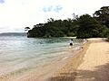
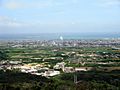
Nago, Okinawa Prefecture, Japan
-
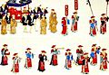
A Ryukyuan embassy in Edo.
-
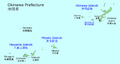
The islands of Okinawa Prefecture
-
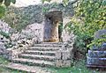
Arch at an Okinawan Castle ruin.
-
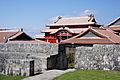
Shuri Castle, Naha
-
Ishigaki
-
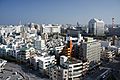
Naha
-
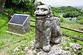
Shisa
-
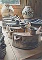
Awamori pots
-
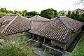
Nakamura house
-
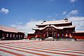
Shuri Castle in Naha


See also
 In Spanish: Prefectura de Okinawa para niños
