
Okutama, Tokyo facts for kids
Quick facts for kids
Okutama
奥多摩町
|
||
|---|---|---|
|
City
|
||
|
||
| Country | Japan | |
| Region | Kantō | |
| Prefecture | Tokyo | |
| Area | ||
| • Total | 225.63 km2 (87.12 sq mi) | |
| Population
(August 1, 2007)
|
||
| • Total | 6,712 | |
| • Density | 29.75/km2 (77.1/sq mi) | |
| Time zone | UTC+9 (Japan Standard Time) | |
| - Tree | Cryptomeria | |
| - Flower | Azalea | |
| - Bird | Copper Pheasant | |
| Address | 215-6, Hikawa, Okutama Town, Nishitama-gun, Tokyo 198-0212 |
|
| Website | Town of Okutama | |

Okutama (奥多摩町, Okutama-machi) is a town in Greater Metropolitan Tokyo, Japan.
Geography
Okutama has an area of 225.63 km². Mount Kumotori, Tokyo's highest peak at 2017 m, divides Okutama from the Okuchichibu region of the neighboring Saitama and Yamanashi Prefectures. Tokyo's northernmost and westernmost points lie in Okutama, as does Lake Okutama, an important source of water for Tokyo, located above the Ogōchi Dam in the town.
Images for kids
-
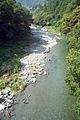
Fishing is popular in Okutama.
-
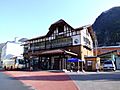
Oku-Tama Station
-
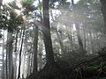
A forest in the Okuchichibu Mountains
-
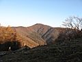
View of Mount Kumotori from Mount Nanatsuishi


See also
 In Spanish: Okutama (Tokio) para niños

All content from Kiddle encyclopedia articles (including the article images and facts) can be freely used under Attribution-ShareAlike license, unless stated otherwise. Cite this article:
Okutama, Tokyo Facts for Kids. Kiddle Encyclopedia.