
Bristol city centre facts for kids
Quick facts for kids Bristol City Centre |
|
|---|---|
| Central Business District | |
.jpg) Roofscape of central Bristol |
|

Bristol City Centre
|
|
| Unitary authority |
|
| Country | England |
| Sovereign state | United Kingdom |
| Post town | BRISTOL |
| Postcode district | BS1, BS8 |
| Dialling code | 0117 |
| UK Parliament |
|
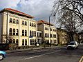
Bristol City Centre is the commercial, cultural and business centre of Bristol, England. It is the area north of the New Cut of the River Avon, bounded by Clifton Wood and Clifton to the north-west, Kingsdown and Cotham to the north, and St Pauls, Lawrence Hill and St Phillip's Marsh to the east. The Bristol Royal Infirmary, Bristol Royal Hospital for Children, the BBC, the main campus of the University of Bristol, the Crown and Magistrate's Courts, Temple Meads railway station, Bristol bus station, the Park Street, Broadmead and Cabot Circus shopping areas together with numerous music venues, theatres and restaurants are located in this area. The area consists of the council wards of Central, Hotwells & Harbourside, and part of Lawrence Hill.
Historic centre
The historic heart of the city was immediately north of Bristol Bridge, between the River Frome and the River Avon, in the area of High Street, Broad Street and Corn Street. The eastern part of this area, between the bridge and Bristol Castle, was destroyed in 1940 during the Bristol Blitz, but the western part largely survived, and contains many historic buildings.
After the war, the blitzed area was redeveloped, and Castle Park was also created.
The Centre
The course of the River Frome, immediately to the west of the historic centre, was covered over in stages, in the second half of the 19th century. The area became the hub of the city's tramway network, and was known as the Tramways Centre. It was so called long after the last trams left in 1939, but is now known simply as the Centre.
Between 1936 and 1938, the Centre was enlarged when more of the River Frome, between Broad Quay and St Augustine's Parade, was covered in, making way for an inner ring road. These planning decisions are beginning to be reversed, for example, the ring road is no longer circular, as the stretch through Queen Square has been closed and returned to its use as a public park. St Augustine's Parade is also becoming less car oriented, as roads have been narrowed, turned into bus lanes or closed altogether. The Centre was redeveloped for the millennium, with fountains and a cascade being erected.

Broadmead
The area northeast of the historic area, around Broadmead, was redeveloped after the war despite overwhelming public opinion against it, and the streets and shops in Broadmead became the main shopping district of the city. Like most 1950s buildings in Britain, affordable but architecturally uninteresting utilitarian buildings form the bulk of the Broadmead area.
In the 1980s, some of these were demolished to make way for the Galleries shopping centre, which is a three level covered street. In 2008, the shopping area was extended over the central ring road to produce a new shopping centre, Cabot Circus, which opened in September 2008.

Harbourside
The City Docks were immediately south of the Centre. Although most ships used Avonmouth Docks after the Royal Edward Dock was opened in 1908, ocean-going ships were regularly seen at the Centre until the 1960s. In 1972 the Royal Portbury Dock was opened, and the City Docks were closed. The harbour buildings, including the tobacco warehouses, became redundant.
The harbourside has been regenerated in the 1990s and 2000s, with the refurbishment of warehouses as bars, restaurants, the Watershed Media Centre and the Arnolfini art gallery, as well as the creation of At-Bristol.

Old City
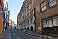
Old City is the peninsular area to the north east of St Augustine's Reach, It contains St Nicolas Market, Queen Square, King Street and many bars and restaurants, it is a key part of Bristol's night life.
Images for kids
-
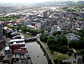
The channelled River Avon (the Floating Harbour) flows through the city centre; most of the central part of the City of Bristol is shown here
-
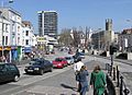
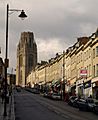
The Centre, seen from the bottom of Park Street
-
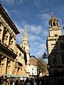
Corn Street, heart of the Old City
-
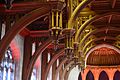
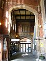
Hammerbeam roof in the Great Hall of the Wills Memorial Building, University of Bristol
-
BBC Bristol TV Studios, Whiteladies Road
-

Sculpture outside Bristol Children's Hospital
-
Crown Court, Small Street
-
Booking Office, Temple Meads Station
-
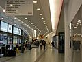
Bristol Bus Station
-
Park Street and Wills Memorial Building


