
Orange County, Virginia facts for kids
Quick facts for kids
Orange County
|
||
|---|---|---|

Orange County Courthouse
|
||
|
||

Location within the U.S. state of Virginia
|
||
 Virginia's location within the U.S. |
||
| Country | ||
| State | ||
| Founded | 1734 | |
| Named for | Prince William IV of Orange | |
| Seat | Orange | |
| Largest town | Orange | |
| Area | ||
| • Total | 343 sq mi (890 km2) | |
| • Land | 341 sq mi (880 km2) | |
| • Water | 2.5 sq mi (6 km2) 0.7% | |
| Population
(2020)
|
||
| • Total | 36,254 | |
| • Density | 105.70/sq mi (40.81/km2) | |
| Time zone | UTC−5 (Eastern) | |
| • Summer (DST) | UTC−4 (EDT) | |
| Congressional district | 7th | |

Orange County is a county located in the Central Piedmont region of the Commonwealth of Virginia. At the 2020 census, the population was 36,254. Its county seat is Orange. Orange County includes Montpelier, the 2,700-acre (1,100 ha) estate of James Madison, the 4th President of the United States and often known as the "Father of the Constitution". The county celebrated its 275th anniversary in 2009.
Contents
History
The area was inhabited for thousands of years by various cultures of indigenous peoples. At the time of European encounter, the Ontponea, a sub-group of the Siouan-speaking Manahoac tribe, lived in this Piedmont area.
The first European settlement in what was to become Orange County was Germanna, formed when Governor Alexander Spotswood settled 12 immigrant families from Westphalia, Germany there in 1714; a total of 42 people. Orange County, as a legal entity, was created in August 1734 when the Virginia House of Burgesses adopted "An Act for Dividing Spotsylvania County." Unlike other counties whose boundaries had ended at the Blue Ridge Mountains, Orange was bounded on the west "by the utmost limits of Virginia" which, at that time, stretched to the Mississippi River and the Great Lakes. The colony of Virginia claimed the land, but very little of it had yet been occupied by any English. For this reason, some contend that Orange County was at one time the largest county that ever existed. This situation lasted only four years; in 1738 most of the western tract was split off into Augusta County. The expansiveness of the county boundaries was to encourage settlement further westward as well as to contend against the French claim to the Ohio Valley region.
While no battles of the American Revolution were fought in Orange County, two companies of 50 men each from the county were recruited to the Culpeper Minutemen, which fought in the Battle of Great Bridge, among other engagements.
The development of transportation infrastructure, including several railroad routes, up through the mid-nineteenth century helped foster a diversified agricultural economy in Orange County. The final adjustment of the county’s boundaries occurred in 1838, when Greene County was created from the western portion of Orange. The Town of Orange was legally established in 1834 (officially becoming a town in 1872) and had already served as the county seat for nearly a century; the Town of Gordonsville officially became a town in 1870.
The county saw limited conflict during the Civil War, with most activity being centered around the towns of Orange and Gordonsville. The exceptions were the Battle of Mine Run and the Battle of the Wilderness in the eastern portion of the county, the latter of which served as a significant turning point in the war. Following Virginia's readmission to the Union in 1870, and with the loss of slave labor, the agricultural economy resumed with more emphasis on livestock and dairy farming due to these activities requiring less physical labor. The dominance of the railroad and the relative ease it offered in delivering goods to larger markets increased the relevance and value of livestock production in the county’s agricultural economy. Agriculture and manufacturing continued to expand into the twentieth century, with a peak of 1279 farms and 20 manufacturing companies located within the county as of 1929. A manufacturing survey produced during the Great Depression noted that Orange County’s economy remained relatively healthy due to its accessibility.
The significance of agriculture to Orange County's history was great enough that the Commonwealth of Virginia, by way of the Virginia Landmarks Register, designated approximately 31,200 acres (126 km2) in the western portion of the county as the Madison-Barbour Rural Historic District. The District was added to the National Register of Historic Places in 1991 and is the largest such district in Virginia. It includes James Madison’s Montpelier, James Barbour’s Thomas Jefferson-designed Barboursville mansion (now in ruins), several plantations, portions of the Monticello Viticultural Area, as well as numerous other sites listed on the National Register.
Orange County's population fluctuated up and down following the Civil War up through the 1930s. From that point forward, the population continued to grow steadily, representing an almost 300% increase through the 2010 Census.
Geography
According to the U.S. Census Bureau, the county has a total area of 343 square miles (890 km2), of which 341 square miles (880 km2) is land and 2.5 square miles (6.5 km2) (0.7%) is water. The terrain is characterized by rolling hills, generally increasing in altitude and slope as they continue westward toward the Blue Ridge Mountains. The highest point is Cowherd Mountain at 1,196 ft (345 m), approximately 2.5 miles (4 km) northwest of Gordonsville.
Orange County lies within the watersheds of both the Rappahannock River and the York River, both of which drain into the Chesapeake Bay.
Adjacent counties
- Madison County – northwest
- Culpeper County – north
- Spotsylvania County – east
- Louisa County – south
- Albemarle County – southwest
- Greene County – west
Waterbodies
- The Rapidan River defines the northern boundary of the county
- The 500-acre Main Lake in Lake of the Woods
Nationally protected areas
- The Wilderness Battlefield in the eastern portion of the county lies within the Fredericksburg & Spotsylvania National Military Park
Transportation

Major highways
 US 15
US 15 US 33
US 33 US 522
 SR 3
SR 3 SR 20
SR 20 SR 231
Airports
Public transportation
- The Town of Orange Transit (TOOT) provides bus service around and between the towns of Orange and Gordonsville
Demographics
| Historical population | |||
|---|---|---|---|
| Census | Pop. | %± | |
| 1790 | 9,921 | — | |
| 1800 | 11,449 | 15.4% | |
| 1810 | 12,323 | 7.6% | |
| 1820 | 12,913 | 4.8% | |
| 1830 | 14,637 | 13.4% | |
| 1840 | 9,125 | −37.7% | |
| 1850 | 10,067 | 10.3% | |
| 1860 | 10,851 | 7.8% | |
| 1870 | 10,396 | −4.2% | |
| 1880 | 13,052 | 25.5% | |
| 1890 | 12,814 | −1.8% | |
| 1900 | 12,571 | −1.9% | |
| 1910 | 13,486 | 7.3% | |
| 1920 | 13,320 | −1.2% | |
| 1930 | 12,070 | −9.4% | |
| 1940 | 12,649 | 4.8% | |
| 1950 | 12,755 | 0.8% | |
| 1960 | 12,900 | 1.1% | |
| 1970 | 13,792 | 6.9% | |
| 1980 | 18,063 | 31.0% | |
| 1990 | 21,421 | 18.6% | |
| 2000 | 25,881 | 20.8% | |
| 2010 | 33,481 | 29.4% | |
| 2020 | 36,254 | 8.3% | |
| U.S. Decennial Census 1790-1960 1900-1990 1990-2000 2010 2020 |
|||
2020 census
| Race / Ethnicity | Pop 2010 | Pop 2020 | % 2010 | % 2020 |
|---|---|---|---|---|
| White alone (NH) | 27,033 | 27,389 | 80.74% | 75.55% |
| Black or African American alone (NH) | 4,206 | 4,304 | 12.56% | 11.87% |
| Native American or Alaska Native alone (NH) | 80 | 92 | 0.24% | 0.25% |
| Asian alone (NH) | 240 | 311 | 0.72% | 0.86% |
| Pacific Islander alone (NH) | 15 | 18 | 0.04% | 0.05% |
| Some Other Race alone (NH) | 49 | 156 | 0.15% | 0.43% |
| Mixed Race/Multi-Racial (NH) | 719 | 1,813 | 2.15% | 5.00% |
| Hispanic or Latino (any race) | 1,139 | 2,171 | 3.40% | 5.99% |
| Total | 33,481 | 36,254 | 100.00% | 100.00% |
Note: the US Census treats Hispanic/Latino as an ethnic category. This table excludes Latinos from the racial categories and assigns them to a separate category. Hispanics/Latinos can be of any race.
2010 Census
At the 2010 census there were 33,481 people, 12,895 households (14,616 total housing units) and 9,342 families residing in the county. The county experienced a population increase of 29%, or 7,600 people, since the 2000 census. This ties with Louisa County as the 11th fastest growing county in the commonwealth, and one of the fastest outside of Northern Virginia. The racial makeup of the county was 82.4% White, 12.7% Black or African American, 0.3% Native American, 0.7% Asian, 0.01% Pacific Islander, 1.4% from other races, and 2.4% from two or more races. 3.4% of the population were Hispanic or Latino of any race.
Of the 12,895 households, 27.8% had children under the age of 18 living with them, 56.8% were married couples living together, 10.9% had a female householder with no husband present, and 27.6% were non-families. Out of the total number of households, 32.6% housed someone who was 65 years of age or older. The average household size was 2.55 and the average family size was 2.97.
The age distribution of the population was 22.9% under the age of 18, 6.7% from 18 to 24, 10.7% from 25 to 44, 28.5% from 45 to 64, and 18.1% who were 65 years of age or older. The median age was 42.6 years. For every 100 females there were 96 males.
The median household income was $56,837 and the median family income was $65,195. The per capita income was $26,820 and approximately 11.5% of the population was below the poverty line. Orange County had the 9th longest mean travel time to work (37 minutes) out of 132 Virginia localities polled. The median home value was $238,500.
Development issues


In September 2008, Wal-Mart submitted an application for a special use permit to build a 141,000-square-foot (13,100 m2) Supercenter store less than one quarter mile from the National Park Service Boundary of the Wilderness Battlefield. It would be situated on a 52-acre (210,000 m2) tract just north of the Route 3/Route 20 intersection in eastern Orange County. The Orange County Board of Supervisors formally approved the application on August 25, 2009. On September 23, 2009, the National Trust for Historical Preservation, Friends of the Wilderness Battlefield and six nearby citizens filed suit against the Board of Supervisors claiming the store was likely to produce a significant increase in traffic and subsequent development, among other counts. The National Trust was dropped from the suit for lack of legal standing, and Wal-Mart, its chosen developer and the property owner were later named as additional defendants.
The lawsuit garnered national media attention, with actor Robert Duvall and filmmaker Ken Burns taking a formal stand against the project. On January 26, 2011, the morning before the trial was set to begin, Wal-Mart submitted a statement to the court abandoning its plans for the store. In that statement, the company also agreed to purchase the subject property without developing it, to reimburse Orange County for its legal and administrative expenses related to the lawsuit and to find another site elsewhere in the county. The lawsuit was formally dismissed on May 12, 2011.
Wal-Mart announced their selection on May 23, 2011 of a new site in the county, approximately 4 miles west of the original site, in the Germanna area of Locust Grove. Following approval of a new special use permit from the Board of Supervisors, the new store officially opened on July 10, 2013. The original plaintiffs in the lawsuit, along with other preservationist groups, expressed approval of Wal-Mart's new site and their decision to abandon their original plans. In August 2013, Wal-Mart dedicated 25 feet of right-of-way from the original site to the Commonwealth of Virginia and 70 feet of right-of-way to the county for future transportation improvements. In September 2013, Walmart deeded the remainder of the site (approximately 48 acres) to the Virginia Department of Historic Resources.
Subsequent to the selection of the new location, the county board of supervisors reduced the amount of tax revenue collected annually through the merchants capital tax by 15% (11% in 2010, 2% in 2011, and 2% in 2012), this tax is determined by the value of inventory carried by a local business. In 2011 the county lost $599,690 in revenue provided by the federal government, and rather than adjust the annual budget or restore the merchants capital tax, the board approved a 16% personal property tax increase to raise an additional $666,141 of revenue for the county.
An October 2013 revision to the county's 2009 comprehensive plan was met with overwhelming opposition by local residents concerned that the plans vision to, "Sustain the rural character of Orange County while enhancing and improving the quality of life for all its citizens" is not accurately reflected in the documents development friendly wording. The plan was passed by the Board of Supervisors on December 17, 2013 by a vote of 3-1.
Continuing to push their development agenda, on February 21, 2013, members of the Orange County planning commission, voted to approve a re-zoning application in the Germanna area, and redesignate what had been an Agricultural zone to a commercial and high-density residential area. Despite 90% of the local residents in attendance request for denial, and obvious ethical and conflict of interest issues, the application was passed by J.P. Tucker III (Owner of a construction company), Andy Hutchinson (Owner of a sod company), and Donald Brooks (political candidate for Sheriff).
In May 2013, the county board of supervisors passed a resolution to create the Route 3 Strategic Initiative; this resolution was based on a nine-year-old survey taken at the beginning of the 60% increase in population during the 2000s. Public comment was solicited in three half-hour sessions only after the board dinner break during three monthly board meetings. The initiative which impacts Districts 4 and 5 is being spearheaded by District 2 supervisor Jim White, and may further the conflict between developers and local residents wishing to keep the area rural in character.
An October 2013 revision of the Orange County comprehensive plan generated much public derision when its goal to "Sustain the rural character of Orange County while enhancing and improving the quality of life for all its citizens" conflicted with its pro-development content. Despite the public outcry, the plan was passed by the Board of Supervisors on December 17, 2013, by a vote of 3–1.
On December 9, 2014, Orange County supervisors Lee Frame and James White, planning commission member P. Nigel Goodwin, and Economic Authority members William Hager and Winston Sides proposed a land use plan entitled the Germanna-Wilderness Area Plan (GWAP) after consulting with private sector developers, financial analysts, and engineers, without seeking input from local residents. While the plan was created over 570 days, residents have only been provided a 24-day window, during the holiday season, for comments.
Places of historical significance
As of November 2013, Orange County is home to 34 sites listed on the National Register of Historic Places, including Barboursville, the Germanna Site, the Madison-Barbour Rural Historic District (the largest such district in Virginia) and the historic downtowns of both Orange and Gordonsville.

The Wilderness Battlefield
The Battle of the Wilderness was fought in Orange County on May 5–7, 1864. The battle marked the first occasion Generals Ulysses S. Grant and Robert E. Lee would face each other in the Civil War. The fighting at the Wilderness, while tactically inconclusive, was the first battle in Grant's Overland Campaign that would ultimately lead to the fall of Richmond and Lee’s surrender at Appomattox.
Over 160,000 troops were engaged at the Wilderness in trench warfare and back-and-forth flanking attacks through the surrounding woodlands. When the guns fell silent on May 7, over 23,000 soldiers lay dead or wounded on the fields at the Wilderness, with thousands more either captured or missing. Grant’s Union army disengaged and continued southward to fight the Battle of Spotsylvania Court House and ultimately press on toward Richmond.
Today, the Battle of the Wilderness is a part of the Fredericksburg and Spotsylvania National Military Park, which has preserved 2,773 acres (11.22 km2) of the original battlefield.

Ellwood Manor
Ellwood Manor is the only surviving house that witnessed the Battle of the Wilderness in May 1864. During the battle, Ellwood became a base of operations for the Union Army as Union General Ulysses S. Grant made his headquarters nearby. Ellwood would also play a role in the Battle of Chancellorsville in 1863 when Confederate General Stonewall Jackson, who was wounded during the battle, had his arm amputated and buried in the family cemetery at Ellwood. Following the battle at Chancellorsville, Ellwood served as a Confederate hospital.
In 2008, Ellwood was named “Favorite Virginia Civil War Site” by the Rappahannock Electric Cooperative’s “Cooperative Living” magazine.

Montpelier
Monteplier is the 2,700-acre plantation estate of James Madison, the 4th President of the United States and oft-hailed "Father of the Constitution." The original portion of the home was constructed around 1764 by Madison's father, James Madison Sr., with 2 major additions coming later in 1800 and 1812. The National Trust for Historic Preservation has owned the Montpelier estate since 1984. From 2003-2008 a $25 million renovation was performed on the property, returning both the home and grounds to their 1820 state as they were when occupied by James and his wife Dolley. Montpelier was designated a National Historic Landmark in 1960 and has been on the National Register of Historic Places since 1966. Both Madison and Dolley are buried in the family cemetery on the property.
The Exchange Hotel

A well-preserved example of 19th century Georgian architecture, the Exchange Hotel stands in the Town of Gordonsville as a living piece of Civil War history. Built in 1860 as a hotel on the Virginia Central Railroad, the building was soon transformed into the Gordonsville Receiving Hospital following the onset of the American Civil War. Because of its strategic location along a major railroad and proximity to nearby battlefields, the hospital treated over 70,000 wounded men by the end of the war. During Reconstruction, the hotel was known as the Freedman's Bureau Hospital which served newly freed slaves. The building eventually returned to its former use as a hotel, before being restored in 1971 and transformed into a museum. It is the only remaining Civil War era receiving hospital in Virginia.
Receiving hospitals during the Civil War functioned as triage centers, providing short-term medical care until doctors forwarded patients to other towns or medical facilities. These hospitals were normally located in large cities or on routes where patients were to change their mode of transportation and continue on to other destinations. Receiving hospitals, otherwise known as depot hospitals or clearing hospitals, were marked by short patient stays and a high turnover rate.
Communities
Towns
Census-designated place
Unincorporated communities
- Barboursville
- Burr Hill
- Lahore
- Locust Grove
- Montpelier Station
- Nasons
- Rapidan
- Rhoadesville
- Somerset
- Unionville
Economy
Orange County businesses generated over $200 billion in taxable sales in 2012. The top five industries by taxable sales, as classified by the NAICS, were food and beverage stores, food services and drinking places, gasoline stations, general merchandise dealers and motor vehicle and parts dealers. The top five industries by employment were local government, retail trade, manufacturing, accommodations and food services, and wholesale trade. In July 201), the top five private-sector employers are Dogwood Village, Macmillan Publishing Solutions, Battlefield Farms Inc., American Woodmark Corp. and Aerojet Rocketdyne. However, small businesses were the predominant employer type, with 65% of all Orange County businesses employing four or fewer workers.
Agriculture is an important part of the county's economy, of which nursery, greenhouse, floriculture and sod (NAICS category) represent the largest sector. Orange County is Virginia's top producer in this market sector. The equestrian and forestry industries are also large sectors within the agricultural economy of the county. In addition, tourism (particularly related to history, wine and agritourism) is a significant and growing portion of the economy.
Unemployment over the years has remained considerably below the United States average and slightly above that of Virginia. Recent studies show a 6% unemployment rate, which is the second highest rate in the region. The highest-paid industry in Orange County in 2012 was finance and insurance, followed by pProfessional/scientific/technical services, educational services and transportation/warehousing. The highest-paid was accommodations/food services, followed by arts/entertainment/recreation, health care/social assistance and retail trade. The average weekly wage across all industries was $671.
Wine
Portions of Orange County lie within the Monticello Viticultural Area. Four wineries are located within the county: Barboursville Vineyards, Horton Vineyards, Chateau MerrillAnne and the Reynard Florence Vineyard. In 2012, Orange County contained 214 acres (868 short tons) worth of wine grape production, which was the third highest of all counties in the state. Tonnage of grapes produced and acreage devoted to production in the county has risen 60% and 72%, respectively, since 2004. This is representative of the growing wine industry in Virginia, which contributed a total of $747 billion to the state economy in 2010.
Education

Primary and secondary education is provided by Orange County Public Schools, whose current (as of April 2019) superintendent is Dr. Cecil Snead . The school board is represented by five elected officials, one from each district, whose terms run for three years.
List of previous superintendents. Dr. Dennis Kellison 1996-
Dr. Dave Baker
William Crawford 2005- Nov 2008
Roy Walton (interim)
Dr. Robert Grimesey xxxx-2014
Dr Brenda Tanner 2014- current
Primary schools
- Gordon-Barbour Elementary
- Lightfoot Elementary
- Locust Grove Elementary
- Locust Grove Primary
- Orange Elementary
- Unionville Elementary
Secondary schools
- Locust Grove Middle
- Prospect Heights Middle
- Orange County High School
Post-secondary
Germanna Community College maintains a 65,000 ft2 (6,000 m2) facility on a 100-acre campus in Locust Grove which houses the college's Nursing and Allied Health programs. The facility, as part of the Virginia Community College System, includes classrooms, laboratories, faculty offices, a wellness center, student lounge and bookstore, as well as trails throughout the surrounding woodlands. Due to the growing demand for nursing and health professionals, in August 2013, the college has planned for expansion of the campus.
Issues
In October 2014, 33% of the county-run schools failed to meet state accreditation levels resulting in a warning being issued by the Virginia Department of Education. If the schools in question, Lightfoot, Unionville, and Prospect Heights, failed to meet accreditation levels for three consecutive years their accreditation would be denied. County residents paid $51,564,565.00 in taxes for educational operating expenses in 2015, an increase of 11% ($5,684,921.00) in four years.
The former location of the Locust Grove Middle School was abandoned in 2011 after a new school was built less than two miles away. In 2013, plans were underway to return the students to the original location due to what was referred to as cohabitation issues at the new school and a projected "boom" of approximately 20 third graders. This perceived increase was actually a return to prior attendance levels due to an anomalous single year decrease. The initial cost to taxpayers to reopen the school was estimated at over $611,000.
Notable people
- Edna Lewis, African-American cookbook author and chef, "whose cookbooks revived the nearly forgotten genre of refined Southern cooking"
- Nannie Helen Burroughs, African-American educator, orator, religious leader and businesswoman
- Elijah Craig, Baptist minister who was arrested in Fredericksburg in the cause of religious freedom before the Revolution; later followed after brother Rev. Lewis Craig, leader of "The Travelling Church" to Kentucky in 1781
- Chris Haney, Major League Baseball pitcher
- Patrick Kilpatrick, actor
- Dwayne "The Rock" Johnson, actor and professional wrestler; maintains an estate in the county
- Randolph Scott, western film actor
- James Taliaferro, former U.S. senator for Florida
- Zachary Taylor, 12th President of the United States
- James Barbour, the 18th Governor of Virginia, US Senator, and United States Secretary of War
- James Madison, the 4th President of the United States and "Father of the Constitution"
- Lewis R. Bradley, second Governor of Nevada in the United States from 1871 to 1879; born in Orange County.
Images for kids
-
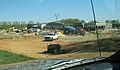
Locust Grove WalMart under construction
-
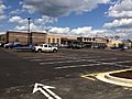
Locust Grove Walmart completed
-
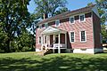
Ellwood Manor
.jpg)
See also
 In Spanish: Condado de Orange (Virginia) para niños
