Orange Cove, California facts for kids
Quick facts for kids
Orange Cove, California
|
||
|---|---|---|
| City of Orange Cove | ||

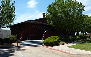
City Hall located in the former Orange Cove Santa Fe Railway Depot
|
||
|
||

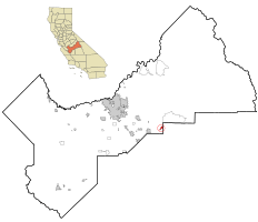
Location in Fresno County and the U.S. state of California
|
||
| Country | United States | |
| State | California | |
| County | Fresno | |
| Incorporated | January 20, 1948 | |
| Area | ||
| • Total | 1.79 sq mi (4.64 km2) | |
| • Land | 1.79 sq mi (4.64 km2) | |
| • Water | 0.00 sq mi (0.00 km2) 0% | |
| Elevation | 423 ft (129 m) | |
| Population
(2010)
|
||
| • Total | 9,078 | |
| • Estimate
(2019)
|
10,273 | |
| • Density | 5,732.70/sq mi (2,213.65/km2) | |
| Time zone | UTC-8 (PST) | |
| • Summer (DST) | UTC-7 (PDT) | |
| ZIP codes |
93646, 93675
|
|
| Area code | 559 | |
| FIPS code | 06-54008 | |
| GNIS feature IDs | 277569, 2411327 | |
Orange Cove is a city in Fresno County, California, United States. The population was 9,078 at the 2010 census, up from 7,722 at the 2000 census.
Geography
According to the United States Census Bureau, the city has a total area of 1.9 square miles (4.9 km2), all of its land.
Climate
According to the Köppen Climate Classification system, Orange Cove has a warm-summer Mediterranean climate, abbreviated "Csa" on climate maps.
History
Elmer M. Sheridan founded the town in 1914, and named it prior to large scale citrus growing. The first post office opened in 1914. The city incorporated in 1948.
Demographics
| Historical population | |||
|---|---|---|---|
| Census | Pop. | %± | |
| 1950 | 2,395 | — | |
| 1960 | 2,885 | 20.5% | |
| 1970 | 3,392 | 17.6% | |
| 1980 | 4,026 | 18.7% | |
| 1990 | 5,604 | 39.2% | |
| 2000 | 7,722 | 37.8% | |
| 2010 | 9,078 | 17.6% | |
| 2019 (est.) | 10,273 | 13.2% | |
| U.S. Decennial Census | |||
2010
At the 2010 census Orange Cove had a population of 9,078. The population density was 4,748.6 people per square mile (1,800/km2). The racial makeup of Orange Cove was 3,940 (43.4%) White, 72 (0.8%) African American, 131 (1.4%) Native American, 101 (1.1%) Asian, 3 (0.03%) Pacific Islander, 4,481 (49.4%) from other races, and 350 (3.9%) from two or more races. Hispanic or Latino of any race were 8,413 persons (92.7%).
The census reported that 9,078 people (100% of the population) lived in households, no one lived in non-institutionalized group quarters and no one was institutionalized.
There were 2,068 households, out of which 1,459 (70.6%) had children under the age of 18 living in them, 1,202 (58.1%) were opposite-sex married couples living together, 430 (20.8%) had a female householder with no husband present, 222 (10.7%) had a male householder with no wife present. There were 207 (10%) unmarried opposite-sex partnerships, and 10 (0.5%) same-sex married couples or partnerships. 174 households (8.4%) were one person and 88 (4.3%) had someone living alone who was 65 or older. The average household size was 4.39. There were 1,854 families (89.7% of all households); the average family size was 4.53.
The age distribution was 3,619 people (39.9%) under the age of 18, 1,113 people (12.3%) aged 18 to 24, 2,398 people (26.4%) aged 25 to 44, 1,435 people (15.8%) aged 45 to 64, and 513 people (5.7%) who were 65 or older. The median age was 23.6 years. For every 100 females, there were 100.9 males. For every 100 females age 18 and over, there were 100.1 males.
There were 2,231 housing units at an average density of 1,167.0 per square mile (460/km2), of which 2,068 were occupied, of which 893 (43.2%) were owner-occupied, and 1,175 (56.8%) were occupied by renters. The homeowner vacancy rate was 0.8%; the rental vacancy rate was 9.5%. 4,047 people (44.6% of the population) lived in owner-occupied housing units and 5,031 people (55.4%) lived in rental housing units.
2000
At the 2000 census there were 7,722 people, 1,694 households, and 1,512 families in the city. The population density was 5,030.4 people per square mile (1,900/km2). There were 1,767 housing units at an average density of 1,151.1 per square mile (460/km2). The racial makeup of the city was 33.55% White, 0.31% Black or African American, 2.42% Native American, 1.49% Asian, 58.84% from other races, and 3.38% from two or more races. 90.60% of the population were Hispanic or Latino of any race. There were 1,694 households, 62.7% had children under the age of 18 living with them, 61.2% were married couples living together, 18.6% had a female householder with no husband present, and 10.7% were non-families. 7.1% of households were one person and 3.7% were one person aged 65 or older. The average household size was 4.56 and the average family size was 4.66.
The age distribution was 40.4% under the age of 18, 13.9% from 18 to 24, 28.1% from 25 to 44, 12.6% from 45 to 64, and 5.0% 65 or older. The median age was 23 years. For every 100 females, there were 107.7 males. For every 100 females age 18 and over, there were 108.7 males.
The median income for a household in the city was US$22,357, and the median family income was $22.5 thousand. Males had a median income of $21 thousand versus $16.8 thousand for females. The per capita income for the city was $7.13 thousand. About 39.9% of families and 44.5% of the population were below the poverty line, including 54.6% of those under age 18 and 20.0% of those age 65 or over.
Education
Schools in Orange Cove are part of the Kings Canyon Unified School District. Orange Cove has one High School (Orange Cove High School) and Middle School (Citrus Middle School) as well as three Elementary Schools: Sheridan Elementary School, McCord Elementary School, and A.L. Conner Elementary School.
See also
 In Spanish: Orange Cove para niños


