
Orchard, Colorado facts for kids
Quick facts for kids
Orchard, Colorado
|
|
|---|---|

Washington Avenue in Orchard, Colorado.
|
|

Location of the Orchard CDP in Morgan County, Colorado.
|
|

Orchard, Colorado
Location in the United States
|
|
| Country | |
| State | |
| County | Morgan County |
| Government | |
| • Type | unincorporated town |
| Area | |
| • Total | 3.787 sq mi (9.809 km2) |
| • Land | 3.698 sq mi (9.577 km2) |
| • Water | 0.090 sq mi (0.232 km2) |
| Elevation | 4,409 ft (1,344 m) |
| Population
(2010)
|
|
| • Total | 90 |
| • Density | 24/sq mi (9/km2) |
| Time zone | UTC-7 (MST) |
| • Summer (DST) | UTC-6 (MDT) |
| ZIP Code |
80649
|
| Area code(s) | 970 |
| GNIS feature | Orchard CDP |
Orchard is an unincorporated town, a post office, and a census-designated place (CDP) located in and governed by Morgan County, Colorado, United States. The CDP is a part of the Fort Morgan, CO Micropolitan Statistical Area. The Orchard post office has the ZIP Code 80649. At the United States Census 2010, the population of the Orchard CDP was 90, while the population of the 80649 ZIP Code Tabulation Area was 299 including adjacent areas.
Contents
Geography
Orchard is located at 40°19′51″N 104°07′07″W / 40.33083°N 104.11861°W (40.330843,-104.118633).
Orchard is the town that was used to film James Michener's miniseries Centennial. Most if not all of the remnants of the production sets are now gone.
Demographics
The United States Census Bureau initially defined the Orchard CDP for the United States Census 2010.
| Orchard CDP, Colorado | ||
|---|---|---|
| Year | Pop. | ±% |
| 2010 | 90 | — |
| 2020 | — | |
| Source: United States Census Bureau | ||
Images for kids
-
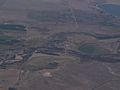
Oblique air photo of Orchard (center) with the South Platte River crossing from left to right, in September 2018

See also
 In Spanish: Orchard (Colorado) para niños
