Oskaloosa, Kansas facts for kids
Quick facts for kids
Oskaloosa, Kansas
|
|
|---|---|
|
City and County seat
|
|

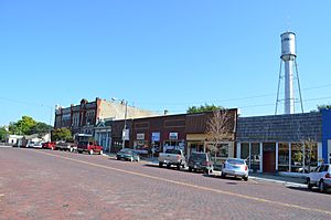
Business district of Oskaloosa (2014)
|
|

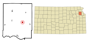
Location within Jefferson County and Kansas
|
|

|
|
| Country | United States |
| State | Kansas |
| County | Jefferson |
| Founded | 1856 |
| Incorporated | 1869 |
| Named for | Oskaloosa, Iowa |
| Area | |
| • Total | 1.00 sq mi (2.59 km2) |
| • Land | 0.99 sq mi (2.57 km2) |
| • Water | 0.01 sq mi (0.01 km2) |
| Elevation | 1,119 ft (341 m) |
| Population
(2010)
|
|
| • Total | 1,113 |
| • Estimate
(2019)
|
1,057 |
| • Density | 1,063.38/sq mi (410.66/km2) |
| Time zone | UTC-6 (CST) |
| • Summer (DST) | UTC-5 (CDT) |
| ZIP code |
66066
|
| Area code | 785 |
| FIPS code | 20-53375 |
| GNIS ID | 0478510 |
Oskaloosa is a city in and the county seat of Jefferson County, Kansas, United States. As of the 2010 census, the city population was 1,113.
History
Oskaloosa was founded in 1856. It was named after the city of Oskaloosa, Iowa. The first post office in Oskaloosa was established in November 1856.
In 1888, Oskaloosa citizens elected Mary D. Lowman mayor with a city council composed entirely of women, making the city the first in the state to electe an all-women city administration.
Geography
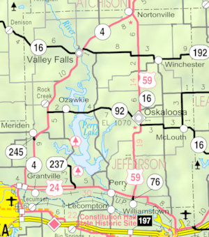
Oskaloosa is located at 39°12′57″N 95°18′50″W / 39.21583°N 95.31389°W (39.215849, -95.313800). It is at the intersection of U.S. Route 59 and K-92, approximately 15 miles north of Lawrence. According to the United States Census Bureau, the city has a total area of 1.03 square miles (2.67 km2), of which, 1.02 square miles (2.64 km2) is land and 0.01 square miles (0.03 km2) is water.
Climate
The climate in this area is characterized by hot, humid summers and generally mild to cool winters. According to the Köppen Climate Classification system, Oskaloosa has a humid subtropical climate, abbreviated "Cfa" on climate maps.
Demographics
| Historical population | |||
|---|---|---|---|
| Census | Pop. | %± | |
| 1860 | 631 | — | |
| 1870 | 640 | 1.4% | |
| 1880 | 725 | 13.3% | |
| 1890 | 773 | 6.6% | |
| 1900 | 978 | 26.5% | |
| 1910 | 851 | −13.0% | |
| 1920 | 700 | −17.7% | |
| 1930 | 733 | 4.7% | |
| 1940 | 800 | 9.1% | |
| 1950 | 721 | −9.9% | |
| 1960 | 807 | 11.9% | |
| 1970 | 955 | 18.3% | |
| 1980 | 1,092 | 14.3% | |
| 1990 | 1,074 | −1.6% | |
| 2000 | 1,165 | 8.5% | |
| 2010 | 1,113 | −4.5% | |
| 2019 (est.) | 1,057 | −5.0% | |
| U.S. Decennial Census | |||
Oskaloosa is part of the Topeka, Kansas Metropolitan Statistical Area.
2010 census
As of the census of 2010, there were 1,113 people, 435 households, and 281 families living in the city. The population density was 1,091.2 inhabitants per square mile (421.3/km2). There were 480 housing units at an average density of 470.6 per square mile (181.7/km2). The racial makeup of the city was 97.0% White, 0.2% African American, 0.8% Native American, 0.3% Asian, 0.1% from other races, and 1.6% from two or more races. Hispanic or Latino of any race were 0.9% of the population.
There were 435 households, of which 33.1% had children under the age of 18 living with them, 43.2% were married couples living together, 16.8% had a female householder with no husband present, 4.6% had a male householder with no wife present, and 35.4% were non-families. 29.2% of all households were made up of individuals, and 14.5% had someone living alone who was 65 years of age or older. The average household size was 2.43 and the average family size was 3.03.
The median age in the city was 39.3 years. 24.5% of residents were under the age of 18; 9% were between the ages of 18 and 24; 23.1% were from 25 to 44; 24.8% were from 45 to 64; and 18.4% were 65 years of age or older. The gender makeup of the city was 50.3% male and 49.7% female.
Education
Oskaloosa is served by Oskaloosa Community School District (USD 341), which has a high school, middle school, and elementary school.
Notable people
- Roger Barker, pioneering sociologist who studied everyday life in Oskaloosa.
- McKinley Burnett, leading figure in Brown v. Board of Education.
- James Reynolds, actor on Days of Our Lives for over 30 years.
- C. Wesley Roberts, chairman of the Republican Party, father of U.S. Senator Pat Roberts.
- Dummy Taylor, deaf Major League Baseball pitcher.
See also
 In Spanish: Oskaloosa (Kansas) para niños

