
Spotswood, New Jersey facts for kids
Quick facts for kids
Spotswood, New Jersey
|
|
|---|---|
|
Borough
|
|
| Borough of Spotswood | |

Spotswood highlighted in Middlesex County
|
|

Census Bureau map of Spotswood, New Jersey
|
|
| Country | |
| State | |
| County | Middlesex |
| Incorporated | May 12, 1908 |
| Government | |
| • Type | Faulkner Act (mayor–council) |
| • Body | Borough Council |
| Area | |
| • Total | 2.42 sq mi (6.26 km2) |
| • Land | 2.31 sq mi (5.98 km2) |
| • Water | 0.11 sq mi (0.28 km2) 4.46% |
| Area rank | 380th of 565 in state 20th of 25 in county |
| Elevation | 36 ft (11 m) |
| Population | |
| • Total | 8,257 |
| • Estimate
(2019)
|
8,228 |
| • Rank | 278th of 566 in state 20th of 25 in county |
| • Density | 3,642.2/sq mi (1,406.3/km2) |
| • Density rank | 175th of 566 in state 13th of 25 in county |
| Time zone | UTC−05:00 (Eastern (EST)) |
| • Summer (DST) | UTC−04:00 (Eastern (EDT)) |
| ZIP Code |
08884
|
| Area code(s) | 732 Exchanges: 251.416,723 |
| FIPS code | 3402369810 |
| GNIS feature ID | 0885405 |
| Website | |
Spotswood is a borough in Middlesex County, New Jersey, United States. The community is nestled within the heart of the Raritan Valley region, with the Manalapan Brook and Matchaponix Brook forming the confluence of the South River (a Raritan River tributary) inside the borough. As of the 2010 United States Census, the borough's population was 8,257, reflecting an increase of 377 (+4.8%) from the 7,880 counted in the 2000 Census, which had in turn declined by 103 (−1.3%) from the 7,983 counted in the 1990 Census.
Contents
History
Its first settler James Johnston originally called the place "Spottiswoode", named for his old place of residence in Scotland, and dates back to its original settlement in 1685.
Spotswood was incorporated as a borough by an act of the New Jersey Legislature on April 15, 1908, from portions of East Brunswick Township, based on the passage of a referendum held on May 12, 1908.
Geography
According to the United States Census Bureau, the borough had a total area of 2.472 square miles (6.402 km2), including 2.267 square miles (5.872 km2) of land and 0.205 square miles (0.531 km2) of water (8.29%). To the north east edge lies Duhernal Lake.
Unincorporated communities, localities and place names located partially or completely within the township include Outcalt, which is located along the border of Spotswood and Monroe Township.
The borough borders the Middlesex County municipalities of East Brunswick Township, Helmetta, Monroe Township and Old Bridge Township.
Demographics
| Historical population | |||
|---|---|---|---|
| Census | Pop. | %± | |
| 1910 | 623 | — | |
| 1920 | 704 | 13.0% | |
| 1930 | 921 | 30.8% | |
| 1940 | 1,201 | 30.4% | |
| 1950 | 2,325 | 93.6% | |
| 1960 | 5,788 | 148.9% | |
| 1970 | 7,891 | 36.3% | |
| 1980 | 7,840 | −0.6% | |
| 1990 | 7,983 | 1.8% | |
| 2000 | 7,880 | −1.3% | |
| 2010 | 8,257 | 4.8% | |
| 2019 (est.) | 8,228 | −0.4% | |
| Population sources: 1910–1920 1910 1910–1930 1930–1990 2000 2010 |
|||
Census 2010
As of the census of 2010, there were 8,257 people, 3,128 households, and 2,143 families residing in the borough. The population density was 3,642.2 per square mile (1,406.3/km2). There were 3,242 housing units at an average density of 1,430.1 per square mile (552.2/km2)*. The racial makeup of the borough was 88.63% (7,318) White, 2.98% (246) Black or African American, 0.11% (9) Native American, 5.14% (424) Asian, 0.01% (1) Pacific Islander, 1.27% (105) from other races, and 1.87% (154) from two or more races. [[Hispanic (U.S. Census)|Hispanic or Latino of any race were 8.32% (687) of the population.
There were 3,128 households out of which 29.3% had children under the age of 18 living with them, 55.0% were married couples living together, 9.7% had a female householder with no husband present, and 31.5% were non-families. 27.1% of all households were made up of individuals, and 15.1% had someone living alone who was 65 years of age or older. The average household size was 2.56 and the average family size was 3.16.
In the borough, the population was spread out with 21.1% under the age of 18, 6.9% from 18 to 24, 24.3% from 25 to 44, 28.8% from 45 to 64, and 18.9% who were 65 years of age or older. The median age was 43.5 years. For every 100 females there were 91.7 males. For every 100 females ages 18 and old there were 86.1 males.
The Census Bureau's 2006–2010 American Community Survey showed that (in 2010 inflation-adjusted dollars) median household income was $70,360 (with a margin of error of +/- $9,861) and the median family income was $90,652 (+/- $8,741). Males had a median income of $59,226 (+/- $4,823) versus $43,365 (+/- $4,935) for females. The per capita income for the borough was $31,249 (+/- $1,696). About 2.5% of families and 3.3% of the population were below the poverty line, including 0.7% of those under age 18 and 6.4% of those age 65 or over.
Census 2000
As of the 2000 United States Census there were 7,880 people, 3,099 households, and 2,163 families residing in the borough. The population density was 3,389.8 people per square mile (1,311.4/km2). There were 3,158 housing units at an average density of 1,358.5 per square mile (525.6/km2). The racial makeup of the borough was 99.24% White, .05% African American, .5% Asian, 0.01% Pacific Islander, and 0.20% from two or more races. Hispanic or Latino of any race were 4.38% of the population.
There were 3,099 households, out of which 29.4% had children under the age of 18 living with them, 57.0% were married couples living together, 9.1% had a female householder with no husband present, and 30.2% were non-families. 26.5% of all households were made up of individuals, and 15.6% had someone living alone who was 65 years of age or older. The average household size was 2.54 and the average family size was 3.10.
In the borough the population was spread out, with 22.4% under the age of 18, 6.8% from 18 to 24, 30.1% from 25 to 44, 23.4% from 45 to 64, and 17.4% who were 65 years of age or older. The median age was 40 years. For every 100 females, there were 93.6 males. For every 100 females age 18 and over, there were 89.9 males.
The median income for a household in the borough was $55,833, and the median income for a family was $73,062. Males had a median income of $45,979 versus $35,859 for females. The per capita income for the borough was $25,247. About 2.6% of families and 4.3% of the population were below the poverty line, including 5.4% of those under age 18 and 2.9% of those age 65 or over.
Transportation
Roads and highways
_at_Summerhill_Road_(Middlesex_County_Route_613)_in_Spotswood,_Middlesex_County,_New_Jersey.jpg)
As of July 2015[update], the borough had a total of 29.51 miles (47.49 km) of roadways, of which 25.52 miles (41.07 km) were maintained by the municipality and 4.07 miles (6.55 km) by Middlesex County.
The main roads that pass through Spotswood include Middlesex CR 613 (Devoe Avenue / Main Street / Summerhill Road) connecting Monroe Township to the south and East Brunswick Township to the north and Middlesex CR 615 (Manalapan Road / Main Street) connecting Helmetta in the southwest to East Brunswick Township in the borough's northwest corner.
Both Route 18 and CR 527 just miss the borough by less than a mile. The closest limited access road is the New Jersey Turnpike (Interstate 95) which is accessible in both neighboring East Brunswick Township (Exit 9) and bordering Monroe Township (Exit 8A).
Public transportation
NJ Transit provides bus service between the borough and the Port Authority Bus Terminal in Midtown Manhattan on the 138 route.
Education
The Spotswood Public Schools serve students in pre-kindergarten through twelfth grade. As of the 2017–18 school year, the district, comprised of four schools, had an enrollment of 1,740 students and 140.1 classroom teachers (on an FTE basis), for a student–teacher ratio of 12.4:1. Schools in the district (with 2017-18 enrollment data from the National Center for Education Statistics) are G. Austin Schoenly Elementary School (235 students; in grades PreK-1), E. Raymond Appleby Elementary School (442; 2-5), Spotswood Memorial Middle School (362; 6-8) and Spotswood High School (679; 9-12).
Students from Helmetta, a non-operating district, attend school in Spotswood beginning in grammar school. Students from Milltown attend the high school as part of a sending/receiving relationship with the Milltown Public Schools.
Immaculate Conception Pre-School (toddler-PreK) and Immaculate Conception School (K-8), which opened in September 1960, operate under the supervision of Roman Catholic Diocese of Metuchen.
Images for kids
-
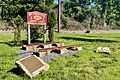
Camden and Amboy Railroad Memorial near East Spotswood Park
-
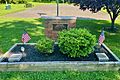
World War Two Memorial at East Spotswood Park


See also
 In Spanish: Spotswood (Nueva Jersey) para niños
