
Ozaukee County, Wisconsin facts for kids
Quick facts for kids
Ozaukee County
|
|
|---|---|

Ozaukee County Courthouse in July 2009
|
|

Location within the U.S. state of Wisconsin
|
|
 Wisconsin's location within the U.S. |
|
| Country | |
| State | |
| Founded | 1853 |
| Seat | Port Washington |
| Largest city | Mequon |
| Area | |
| • Total | 1,116.2 sq mi (2,891 km2) |
| • Land | 233.08 sq mi (603.7 km2) |
| • Water | 883.12 sq mi (2,287.3 km2) |
| Population
(2010)
|
|
| • Total | 86,395 |
| • Estimate
(2020)
|
90,043 |
| • Density | 77.401/sq mi (29.8847/km2) |
| Time zone | UTC−6 (Central) |
| • Summer (DST) | UTC−5 (CDT) |
| Congressional district | 6th |
Ozaukee County is a county in the U.S. state of Wisconsin. As of the 2010 census, the population was 86,395. Its county seat is Port Washington, making it one of three Wisconsin counties on Lake Michigan not to have a county seat with the same name. Ozaukee County is included in the Milwaukee–Waukesha–West Allis, WI Metropolitan Statistical Area.
As of the 2000 Census, Ozaukee County had the second-lowest poverty rate of any county in the United States, at 2.6%. In terms of per capita income, it is the 25th-wealthiest county in the country. Bolstered by low crime rates and school districts with high graduation rates, Forbes magazine ranked Ozaukee County #2 on its list of "America's Best Places To Raise A Family" in June 2008.
Contents
History
Ozaukee County was once part of neighboring Washington County to the west. Its name comes from the Ojibwe name for the Sacs. The word probably means "people living at the mouth of a river."
Geography
According to the U.S. Census Bureau, the county has a total area of 1,116 square miles (2,890 km2), of which 233 square miles (600 km2) is land and 883 square miles (2,290 km2) (79%) is water. It is the second-smallest county in Wisconsin by land area.
Lion's Den Gorge Nature Preserve is a large bluffland and wetland county protected area on the shore of Lake Michigan.
Major highways
 Interstate 43
 Highway 32 (Wisconsin)
 Highway 33 (Wisconsin)
 Highway 57 (Wisconsin)
 Highway 60 (Wisconsin)
 Highway 167 (Wisconsin)
 Highway 181 (Wisconsin)
Adjacent counties
- Sheboygan County - north
- Oceana County, Michigan - northeast
- Muskegon County, Michigan - east
- Milwaukee County - south
- Waukesha County - southwest
- Washington County - west
Demographics
Religious statistics
The Association of Religion Data Archives reported that as of 2010, the largest religious group in Ozaukee County is the Roman Catholic Archdiocese of Milwaukee, with 28,644 adherents spread across eight parishes. Although the number of Catholics in the county is around the same as it was in 1990, the number of parishes has declined from twelve in 1990 to eight in 2010, because of the mergers of small, rural and local parishes into larger, multi-campus parishes, such as the St. John XXIII Congregation in Port Washington and Saukville, which formed from the merger of three parishes and holds services in three church buildings. Other large religious groups in the county include 8,464 Missouri Synod Lutherans with seven congregations, 5,094 ELCA Lutherans with ten congregations, 2,702 Wisconsin Synod Lutherans with seven congregations, 1,795 adherents of the Presbyterian Church (USA) with one congregation, 1,558 adherents of the United Church of Christ with three congregations, 1,154 UMC Methodists with three congregations, 1,061 adherents of the evangelical Christian and Missionary Alliance with two congregations, 794 non-denominational Christians with four congregations, and 695 adherents of Orthodox and Reconstructionist Judaism with three synagogues, as well as other congregations in the Baháʼí, Christian Scientist, evangelical Protestant, Greek Orthodox, Hindu, Jehovah's Witnesses, Latter-day Saints, mainline Protestant, and Unitarian Universalist traditions.
Transportation
Ozaukee County has a harbor in Port Washington on Lake Michigan, though not in the lakeside communities of Mequon or Grafton due to high bluffs along the lakeshore.
The Ozaukee County Interurban Trail is a multimodal trail for pedestrians and non-motorized vehicles. It runs through Grafton and connects to Sheboygan County and Brown Deer Trails via the old Milwaukee-Sheboygan Passenger Rail line.
Public transit is provided by a commuter express bus (Route 143) to Milwaukee with stops in Port Washington, Saukville, Grafton, and Mequon. The bus operates Monday through Fridays excluding holidays, and is run jointly by Milwaukee and Ozaukee County. The county offers a daily shared taxi, with connections to Washington County Transit and Milwaukee County Routes 12, 49 and 42u.
Communities
Cities
- Cedarburg
- Mequon
- Port Washington (county seat)
Villages
- Bayside (mostly in Milwaukee County)
- Belgium
- Fredonia
- Grafton
- Newburg (mostly in Washington County)
- Saukville
- Thiensville
Towns
Census-designated place
Unincorporated communities
- Dacada (partial)
- Decker
- Decker Corner
- Hamilton
- Holy Cross
- Horns Corners
- Knellsville
- Lake Church
- Lakefield
- Little Kohler
- Ulao
- Sauk Trail Beach
Images for kids
-
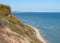
Lake Michigan shoreline, near Port Washington

See also
 In Spanish: Condado de Ozaukee para niños
